Ham Hill Hillfort

Last updated

Ham Hill Hillfort
Ham Hill War Memorial.jpg
Looking east from the highest point of Hamdon Hill (on top of the inner rampart of the hillfort) towards the Stoke-sub-Hamdon war memorial which was unveiled in 1923
Location Ham Hill, Somerset, England
Coordinates 50°57′05″N2°44′38″W / 50.95139°N 2.74389°W / 50.95139; -2.74389 Coordinates: 50°57′05″N2°44′38″W / 50.95139°N 2.74389°W / 50.95139; -2.74389
Area210 acres (85 ha)
Built Iron Age
Reference no.1043362 [1]
Somerset UK location map.svg
Red pog.svg
Location of Ham Hill Hillfort in Somerset

Ham Hill Hillfort is an Iron Age hillfort located on Ham Hill, Somerset, England. It was also occupied during the mesolithic and neolithic periods and later during Roman and medieval eras. The fort is a Scheduled Ancient Monument, [2] and the whole of the hill is a geological Site of Special Scientific Interest, [3] a country park operated by South Somerset Council, and is visited by over 250,000 people each year. [4]

Contents

It covers an area of 210 acres (85 ha), making it one of the largest hillforts in Britain. [5] It is the only one with a public house in its interior. [6]

Background

Hill forts developed in the Late Bronze and Early Iron Age, at roughly the start of the first millennium BC. [7] The reason for their emergence in Britain, and their purpose, have been a subject of debate. It has been argued that they could have been military sites constructed in response to invasion from continental Europe, sites built by invaders, or a military reaction to social tensions caused by an increasing population and consequent pressure on agriculture. The dominant view since the 1960s has been that the increasing use of iron led to social changes in Britain. Deposits of iron ore were located in different places to the tin and copper ore necessary to make bronze; as a result, trading patterns shifted, the old elites lost their economic and social status, and power passed into the hands of a new group of people. [8] Archaeologist Barry Cunliffe believes that population increase still played a role and has stated, "[The forts] provided defensive possibilities for the community at those times when the stress [of an increasing population] burst out into open warfare. But I wouldn't see them as having been built because there was a state of war. They would be functional as defensive strongholds when there were tensions and undoubtedly some of them were attacked and destroyed, but this was not the only, or even the most significant, factor in their construction." [9]

Description

Plan of the Iron Age hill fort at Ham Hill Ham Hill Somerset Map.jpg
Plan of the Iron Age hill fort at Ham Hill

The hill rises to 400 feet (120 m) above sea level and towers over the surrounding Parrett and Yeo river valleys. [10] The 3 miles (5 km) ramparts enclose an area of 210 acres (85 ha). [11] The southern part is a rectangle approximately 800 metres (2,600 ft) by 1,000 metres (3,300 ft) with a northern spur 600 metres (2,000 ft) by 400 metres (1,300 ft) making an irregular L shape. [6]

Most of the perimeter is a double bank and ditch ( multivallate ), with some of the banks being up to 12 metres (39 ft) high. There is a major entrance to the south-east, on the line of the modern road, and another to the north-east, following a track from the Church of St Mary the Virgin at East Stoke in Stoke-sub-Hamdon.

History

The site was occupied during the mesolithic and neolithic periods, [2] [12] and then by the Durotriges tribe, [11] from the 1st century BC. [13]

Sling stones from the site Sling bullets clay and stone.JPG
Sling stones from the site

Archaeological finds, which date the original occupation to the 7th century BC, [6] include bronze-work, chariot parts, iron currency bars, gold and silver coins, cremations and burials. [5] A Glastonbury type pot has also been recovered. [6]

In 2013, excavations revealed some human skeletons and they may date to the first or second century AD. Tool marks on the bones suggest de-fleshing, reflecting both normal local funerary practices and violent episodes. [14] [15]

The site was also important during the Roman era, with many finds indicating that there was a building on the site, possibly a Roman villa. [6] [16] [17] It may also have been the site of a fort that provided a point of control for the Fosse Way. [10] Roman coins, dating from the time of Domitian to Constantine the Great, were contained in a crock found during the 19th century. Other finds include a vessel containing 338 sestertii, which were given to the Museum of Somerset in 1915 by W. R. Phelps, and two other similar pots of coins that together contained slightly over 1,000 coins from Republican Rome to the time of Postumus, which must have been buried at some time after 260. [18] Damaged bronze scales of lorica squamata, a type of scale armour, have also been found. [19]

There is less evidence from the Saxon era, although the site might have been occupied during that period. It was definitely occupied during medieval times and was the site of the deserted hamlet of South Ameldon, which hosted an annual fair and court from 1102 until the 17th century. [6] In the 14th century part of the site was a rabbit warren. [10]

The site, particularly the northern and western areas, has been damaged by quarrying for Hamstone. [2] [20] In the 1800s there were 24 small quarries operating on the hill employing some 200 men. [21] There are now two quarries, both owned by the Duchy of Cornwall, after whom the pub is named. A stone circle was added in 2000 to commemorate all those who have quarried stone on the site since Roman times. [22] It consists of 15 hamstones. [23]

See also

Related Research Articles

<span class="mw-page-title-main">Ham Hill, Somerset</span> Hill fort and country park in England

Ham Hill is a geological Site of Special Scientific Interest (SSSI), Scheduled Ancient Monument, Iron Age hill fort, Roman site, Local Nature Reserve and country park, to the west of Yeovil in Somerset, England.

<span class="mw-page-title-main">Cadbury Castle, Somerset</span> Hillfort in Somerset, England

Cadbury Castle is a Bronze and Iron Age hillfort in the civil parish of South Cadbury in the English county of Somerset. It is a scheduled monument and has been associated with King Arthur's legendary court at Camelot.
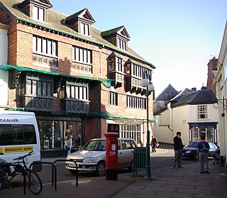
<span class="mw-page-title-main">Cadbury Camp</span> Iron Age hillfort in Somerset, England

Cadbury Camp is an Iron Age hill fort in Somerset, England, near the village of Tickenham. It is a scheduled monument. Although primarily known as a fort during the Iron Age it is likely, from artefacts, including a bronze spear or axe head, discovered at the site, that it was first used in the Bronze Age and still occupied through the Roman era into the sub-Roman period when the area became part of a Celtic kingdom. The name may mean "Fort of Cador" - Cado(r) being possibly the regional king or warlord controlling Somerset, Bristol, and South Gloucestershire, in the middle to late 5th century. Cador has been associated with Arthurian England, though the only evidence for this is the reference in the Life of St. Carantoc to Arthur and Cador ruling from Dindraithou and having the power over western Somerset to grant Carantoc's plea to build a church at Carhampton. Geoffrey of Monmouth invented the title 'Duke of Cornwall' for Cador in his misleading History of the Kings of Britain.

<span class="mw-page-title-main">Hamstone</span> Building stone from Somerset

Hamstone is the name given to a honey-coloured building stone from Ham Hill, Somerset, England. It is a well-cemented medium to coarse grained limestone characterised by marked bedding planes of clay inclusions and less well-cemented material which weather differentially to give exposed blocks a characteristic furrowed appearance. In origin, Hamstone is a Jurassic limestone from the Toarcian, or Upper Lias, stage.

<span class="mw-page-title-main">Worlebury Hill</span>

Worlebury Hill is the name given to an upland area lying between the flatlands of Weston-super-Mare and the Kewstoke area of North Somerset, England. Worlebury Hill's rises from sea level to its highest point of 109 metres (358 ft), and the western end of the hill forms a peninsula, jutting out into the Bristol Channel, between Weston Bay and Sand Bay. A toll road follows the coast around the hill from Sand Bay in the north to the now derelict Birnbeck Pier in the west, although tolls are not currently collected on the road. Worlebury Golf Club is situated on the Hill and the area is known for being one of the wealthiest areas in the county of Somerset.

<span class="mw-page-title-main">Dolebury Warren</span> Hillfort in North Somerset

Dolebury Warren is a 90.6 hectares biological Site of Special Scientific Interest (SSSI) and ancient monument near the villages of Churchill and Rowberrow in North Somerset, part of South West England. It is owned by the National Trust, who acquired the freehold in 1983, and managed by the Avon Wildlife Trust.

<span class="mw-page-title-main">Stoke-sub-Hamdon</span> Village in Somerset, England

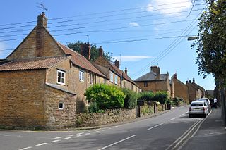
Stoke-sub-Hamdon, also known as Stoke under Ham, is a large village and civil parish in the South Somerset district of Somerset, England. It is situated 5 miles (8 km) west of Yeovil, with which it is linked by the A3088 road. The parish is located near the River Parrett, and includes the village of East Stoke.

<span class="mw-page-title-main">Cannington Camp</span> Hillfort in Somerset, England

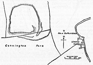
Cannington Camp is a Bronze Age and Iron Age hill fort near Cannington, Somerset, England. It is a Scheduled Ancient Monument.

<span class="mw-page-title-main">Norton-sub-Hamdon</span> Human settlement in England

Norton-sub-Hamdon is a village and civil parish in the South Somerset district of the English county of Somerset, situated five miles west of Yeovil. The village has a population of 743.

<span class="mw-page-title-main">Stoke sub Hamdon Priory</span> Grade I listed building in Somerset, England

Stoke sub Hamdon Priory is a complex of buildings and ruins which initially formed a 14th-century college for the chantry chapel of St Nicholas, and later was the site of a farm in Stoke-sub-Hamdon, Somerset, England. The only building remaining from the college is a great hall and attached dwelling, dating from the late 15th century. The hall is designated by English Heritage as a Grade I listed building, while the outbuildings and gateway are Grade II listed. The whole site has been scheduled as an ancient monument. A number of the farm buildings are in poor condition, and have been added to the Heritage at Risk Register.

<span class="mw-page-title-main">Black Ball Camp</span> Iron Age hillfort in Somerset, England

Black Ball Camp is an Iron Age hillfort South West of Dunster, Somerset, England on the northern summit of Gallox Hill. It is a Scheduled Monument.

<span class="mw-page-title-main">Worlebury Camp</span> Iron Age hillfort in Somerset, England

Worlebury Camp is the site of an Iron Age hillfort on Worlebury Hill, north of Weston-super-Mare in Somerset, England. The fort was well defended with numerous walls, embankments and ditches around the site. Several large triangular platforms have been uncovered around the sides of the fort, lower down on the hillside. Nearly one hundred storage pits of various sizes were cut into the bedrock, and many of these had human remains, coins, and other artefacts in them. During the 19th and 20th centuries the fort suffered damage and was threatened with complete destruction on multiple occasions. Now, the site is a designated Scheduled monument. it falls within the Weston Woods Local Nature Reserve which was declared to Natural England by North Somerset Council in 2005.

<span class="mw-page-title-main">Brent Knoll Camp</span> Iron Age hillfort in Somerset, England

Brent Knoll Camp is an Iron Age hillfort at Brent Knoll, 3 kilometres (1.9 mi) from Burnham-on-Sea, Somerset, England. It has been designated as a Scheduled Monument, and is now in the care of the National Trust.

<span class="mw-page-title-main">Tedbury Camp</span> Iron Age hillfort in Somerset, England

Tedbury Camp is a multivallate Iron Age promontory hill fort defended by two parallel banks near Great Elm, Somerset, England.

<span class="mw-page-title-main">Dundon Hill Hillfort</span> Iron Age hillfort in Somerset, England

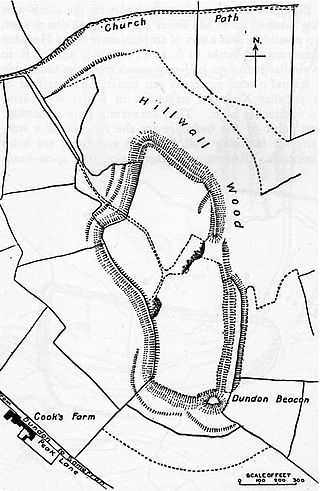
Dundon Hill Hillfort is an Iron Age hillfort in Compton Dundon, Somerset, England. It has been designated as a Scheduled Ancient Monument. South east of the site is a Bronze Age bowl barrow which, it has been suggested, was later modified as a Norman Motte, known as Dundon Beacon.
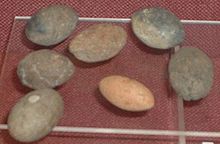
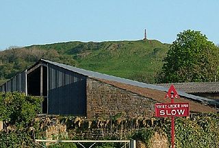
<span class="mw-page-title-main">King's Castle, Wiveliscombe</span> Neolithic hillfort in Somerset, England

King's Castle is a Neolithic hillfort 1 kilometre (0.62 mi) east of Wiveliscombe in Somerset, England. It is surrounded by two banks with a ditch between them. The inner wall ranges up to 2.5 metres (8.2 ft) high and the outer wall gets up to 1.5 metres (4.9 ft) high. Arrowheads, scrapers, and borers have been found at the site. A coin hoard of 1139 coins was found in a pot buried 0.30 metres (1 ft) deep.

Curdon Camp is a univallate Iron Age hill fort in the West Somerset district of Somerset, England. It is a Scheduled Ancient Monument.

Westbury Camp is a univallate Iron Age hill fort in the Mendip Hills in Somerset, England. The hill fort is situated in the parish of Rodney Stoke, approximately 1 mile (1.6 km) north-east of the village of Draycott and 1.5 miles (2.4 km) north-west of Westbury-sub-Mendip. The camp is largely situated in a hill slope. The north east defences have largely been destroyed by small quarries over the years. The narrow top of the hill bank suggests that it may have been surmounted by a dry stone wall. Along part of the east side of the camp there are traces of a berm between the bank and the outer ditch and at the western angle shallow quarry pits occur internally and externally set back from the 'rampart'.

References

  1. "Monument No. 1043362". National Monuments Record. English Heritage. Archived from the original on 2 October 2012. Retrieved 17 March 2011.
  2. 1 2 3 "Hamdon Hill Camp". Somerset Historic Environment Record. Somerset County Council . Retrieved 26 December 2010.
  3. "Ham Hill Site of Special Scientific Interest (SSSI) citation sheet" (PDF). English Nature. Archived from the original (PDF) on 13 October 2006. Retrieved 6 February 2011.
  4. "Ham Hill Country Park". Visit Somerset. Somerset County Council. Retrieved 14 November 2010.
  5. 1 2 "Ham Hill Iron Age Hillfort". Wessex Archaeology. Retrieved 6 February 2011.
  6. 1 2 3 4 5 6 Adkins, Lesley; Rod Adkins (1992). A field guide to Somerset archaeology. Wimborne: Dovecote Press. pp. 72–74. ISBN   0-946159-94-7.
  7. Payne, Andrew; Corney, Mark; Cunliffe, Barry (2007). The Wessex Hillforts Project: Extensive Survey of Hillfort Interiors in Central Southern England. English Heritage. p. 1. ISBN   978-1-873592-85-4.
  8. Sharples, Niall M (1991). English Heritage Book of Maiden Castle. London: B. T. Batsford. pp. 71–72. ISBN   0-7134-6083-0.
  9. "Time Team: Swords, skulls and strongholds". Channel 4. 19 May 2008. Retrieved 16 September 2009.
  10. 1 2 3 Dunning, Robert (1980). Somerset & Avon. Edinburgh: Bartholomew. pp. 87–88. ISBN   0-7028-8380-8.
  11. 1 2 "Ham Hill". Roman Britain.
  12. "Ham Hill Hillfort, S of Stoke sub Hamdon". Digital Digging. Archived from the original on 11 August 2010. Retrieved 10 November 2010.
  13. Dunning, Robert; A. P. Baggs; R. J. E. Bush; Margaret Tomlinson (1974). "Parishes: Montacute". A History of the County of Somerset: Volume 3. British History Online. Retrieved 23 January 2010.
  14. "Ham Hill fort dig reveals 2,500-year-old human remains". BBC Somerset. 2 September 2013. Retrieved 5 September 2013.
  15. Alberge, Dalya (4 September 2013). "Slaughtered bodies stripped of their flesh - a gruesome glimpse of Iron-Age massacre at UK's largest hill fort. Hundreds if not thousands stripped of their flesh and chopped up, say archaeologists". The Independent. London. Retrieved 5 September 2013.
  16. "Roman villa, Ham Hill, Stoke sub Hambdon". Somerset Historic Environment Record. Somerset County Council . Retrieved 6 February 2011.
  17. "Ham Hill geophysical survey area C (1992), Stoke sub Hamdon". Somerset Historic Environment Record. Somerset County Council . Retrieved 6 February 2011.
  18. "Roman occupation, Ham Hill, S of Stoke sub Hamdon". Somerset Historic Environment Record. Somerset County Council . Retrieved 6 February 2011.
  19. "Roman armour find, Ham Hill". Somerset Historic Environment Record. Somerset County Council . Retrieved 6 February 2011.
  20. "Ham Hill". Hillfort in England in Somerset. Megalithic Portal. Retrieved 26 December 2010.
  21. "Medieval and Victorian History". Ham Hill Country Park. South Somerset Council. Archived from the original on 20 November 2010. Retrieved 23 January 2010.
  22. "Geology map". Visit Somerset. Archived from the original on 20 November 2010. Retrieved 6 February 2011.
  23. "Ham Hill, Somerset". Somersetian. Retrieved 6 February 2011.