
Mainz is the capital and largest city of the German state of Rhineland-Palatinate, and with around 221,000 inhabitants, it is Germany's 35th-largest city. It lies in the Rhine-Main Metropolitan Region—Germany's second-largest metropolitan region after Rhine-Ruhr—which also encompasses the cities of Frankfurt am Main, Wiesbaden, Darmstadt, Offenbach am Main, and Hanau.

The Electoral Palatinate or the Palatinate, officially the Electorate of the Palatinate, was a constituent state of the Holy Roman Empire. The electorate had its origins under the rulership of the Counts Palatine of Lotharingia in 915; it was then restructured under the Counts Palatine of the Rhine in 1085. From 1214 until the Electoral Palatinate was merged into the Kingdom of Bavaria in 1805, the House of Wittelsbach provided the Counts Palatine or Electors. These counts palatine of the Rhine would serve as prince-electors from "time immemorial", and were noted as such in a papal letter of 1261; they were confirmed as electors by the Golden Bull of 1356.

The Rhineland is a loosely defined area of Western Germany along the Rhine, chiefly its middle section.

Eltz Castle is a medieval castle nestled in the hills above the Moselle between Koblenz and Trier, Germany. It is still owned by a branch of House of Eltz who have lived there since the 12th century. Eltz Castle along with Bürresheim Castle and Lissingen Castle are the only castles in the Eifel region which have never been destroyed.
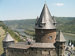
Stahleck Castle is a 12th-century fortified castle in the Upper Middle Rhine Valley at Bacharach in Rhineland-Palatinate, Germany. It stands on a crag approximately 160 metres (520 ft) above sea level on the left bank of the river at the mouth of the Steeg valley, approximately 50 kilometres (31 mi) south of Koblenz, and offers a commanding view of the Lorelei valley. Its name means "impregnable castle on a crag", from the Middle High German words stahel (steel) and ecke. It has a water-filled partial moat, a rarity in Germany. Built on the orders of the Archbishop of Cologne, it was destroyed in the late 17th century but rebuilt in the 20th and is now a hostel.

Bingen am Rhein is a town in the Mainz-Bingen district in Rhineland-Palatinate, Germany.

The Rhine Gorge is a popular name for the Upper Middle Rhine Valley, a 65 km section of the Rhine between Koblenz and Rüdesheim in the states of Rhineland-Palatinate and Hesse in Germany. It was added to the UNESCO list of World Heritage Sites in June 2002 because of its beauty as a cultural landscape, its importance as a route of transport across Europe, and the unique adaptations of the buildings and terraces to the steep slopes of the gorge.

Lahnstein is a verband-free town of Rhein-Lahn-Kreis in Rhineland-Palatinate, Germany. It is situated at the confluence of the Lahn with the Rhine, approximately 6 kilometres (3.7 mi) south of Koblenz. Lahnstein was created in 1969 by the merger of the previously independent towns of Oberlahnstein on the south side of the Lahn and Niederlahnstein on the north side. In 2020, it had a population of 18,030.

Nassau is a town located in the German state of Rhineland-Palatinate. It lies on the lower course of the Lahn River, on the mouth of the Mühlbach, between Limburg an der Lahn and the spa town of Bad Ems, and is located in the Nassau Nature Park, surrounded by the Westerwald to the north and the Taunus to the south. The town is on the German-Dutch holiday road, the Orange Route. As of 2021, it had a population of 4,592.
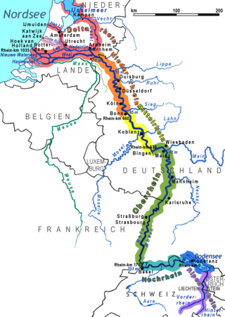
Between Bingen and Bonn, Germany, the river Rhine flows as the Middle Rhine through the Rhine Gorge, a formation created by erosion, which happened at about the same rate as an uplift in the region, leaving the river at about its original level, and the surrounding lands raised. This gorge is quite deep, about 130 metres (430 ft) from the top of the rocks down to the average water-line.

Bad Hönningen is a municipality in the district of Neuwied, in Rhineland-Palatinate, Germany. It is situated on the right bank of the Rhine, approx. 15 km (10 mi) northwest of Neuwied, and 30 km (20 mi) southeast of Bonn.
Schaumburg is a district in Lower Saxony, Germany. Schauenburg is a municipality in Hesse

Rheinbrohl is a municipality in the territorial collectivity of Bad Hönningen, in the district of Neuwied, in Rhineland-Palatinate, in western Germany. On its Rhine bank is the starting point of the Upper Germanic-Rhaetian Limes, the fortification of 550 km length which delimited the Roman Empire. At this place near the Rhine is the reconstruction of a Roman watchtower.
Niederheimbach is an Ortsgemeinde – a municipality belonging to a Verbandsgemeinde, a kind of collective municipality – in the Mainz-Bingen district in Rhineland-Palatinate, Germany.

Rheinstein Castle is a castle near the town of Trechtingshausen in Rhineland-Palatinate, Germany.

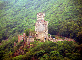
Reichenstein Castle, also known as Falkenburg is a castle in the UNESCO World Heritage Site of the Upper Middle Rhine Valley. It stands on a mountain spur on the eastern slope of the Bingen Forest, above the Rhineland-Palatinate municipality of Trechtingshausen in the Mainz-Bingen district in Germany.
Sooneck Castle is a castle in the upper middle valley of the Rhine, in the Mainz-Bingen district of Rhineland-Palatinate, Germany. It is located near the village of Niederheimbach between Bingen and Bacharach.
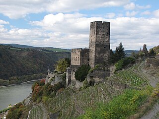
Gutenfels Castle, also known as Caub Castle, is a castle 110m above the town of Kaub in Rhineland-Palatinate, Germany.

The County of Zweibrücken was a territory in the Holy Roman Empire named for Zweibrücken in which is now situated in the Rhineland-Palatinate. It was created sometime between 1182 and 1190 from an inheritance division of the county of Saarbrücken and lasted until 1394.

