Related Research Articles

Sandnes is a city and municipality in Rogaland, Norway. It lies immediately south of Stavanger, the 4th largest city in Norway, and together the Stavanger/Sandnes area is the third-largest urban area in Norway. The urban city of Sandnes lies in the extreme western part of the vast municipality and it makes up about 5% of the total land area of the municipality.

Norddal is a former municipality in Møre og Romsdal county, Norway. It merged with Stordal municipality to establish the new Fjord municipality in 2020. It covered the easternmost part of the Sunnmøre region along the border with Oppland county. The municipal center of the municipality was the village of Sylte in the Valldalen valley.

Strand is a municipality in Rogaland county, Norway. It is located in the traditional district of Ryfylke. The administrative centre of the municipality is the town of Jørpeland. The municipality lies across the fjord from the city of Stavanger. The Ryfast tunnel system connects Stavanger and Strand by a very long undersea tunnel.

The Jæren Line was a 74.7-kilometer (46.4 mi) long railway line between Stavanger and Egersund in Jæren, Norway. The name is no longer in official use and the section is regarded as the westernmost part of the Sørlandet Line. Owned by Bane NOR, the line has double track from Stavanger Station to Sandnes Station, and single track from Sandnes to Egersund Station. The line is electrified at 15 kV 16.7 Hz AC and equipped with centralized traffic control and GSM-R. The line is served by the Jæren Commuter Rail and intercity trains along the Sørlandet Line, both operated by Go-Ahead Norge. CargoNet runs container freight trains on the line, which terminate at Ganddal Freight Terminal.

Sviland is a borough in the southwestern part of the municipality of Sandnes in Rogaland county, Norway. It is located in the rural part of the municipality, southeast of the city of Sandnes. With a population (2020) of only 1,332, the borough is one of the least populous of all the boroughs in Sandnes. On the other hand, Sviland borough is 68.6 square kilometres (26.5 sq mi), making it the second largest borough by area. Sviland Chapel is located in the borough.
The larger Kvernaland area is an amalgamation of villages in Rogaland county, Norway. The village is located along the north end of the lake Frøylandsvatnet. The village is located in both the municipalities of Klepp and Time. The eastern part of the village is also known as Orstad and the western part of the village is known as Frøyland or simply as Kvernaland. The village of Klepp stasjon lies just southwest of the village on the west side of the lake and the small village of Foss Eikjeland lies just north of the village, along the river Figgjo.

Lossivatnet (Norwegian) or Loasejávri (Northern Sami) is a lake in Narvik Municipality in Nordland county, Norway. The 6.64-square-kilometre (2.56 sq mi) lake lies just west of the mountain Storsteinfjellet and about 10 kilometres (6.2 mi) east of the village of Elvegård. The water is used for hydroelectric power production.
Nilsebuvatnet is a lake in the municipalities of Sandnes and Hjelmeland in Rogaland county, Norway. The 2.47-square-kilometre (0.95 sq mi) lake lies in the Lyseheiane mountains about 13 kilometres (8.1 mi) north of the village of Lysebotn and about 25 kilometres (16 mi) east of the village of Årdal. The lake is regulated by a small dam on the southwest corner of the lake. The dam provides water for the Lysebotn power station. The lake drains out into the river Storåna which flows westward towards Årdal. The lake is accessible by a small service road from Lysebotn which leads up to the dam.
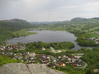
Frøylandsvatnet is a lake in the municipality of Sandnes in Rogaland county, Norway. The 0.48-square-kilometre (120-acre) lake lies on the south side of the village of Hommersåk, about 10 kilometres (6.2 mi) northeast of the city of Sandnes. The lake empties into a small river that runs out of the north end of the lake. The river runs through Hommersåk into an arm of the Gandsfjorden.
Vatne is a village in Sandnes municipality in Rogaland county, Norway. The village lies in the borough of Hana, just about 3 kilometres (1.9 mi) northeast of the centre of the city of Sandnes. The Vatneleiren military base is located in Vatne.
Masfjordnes is the administrative centre of Masfjorden municipality in Vestland county, Norway. The village lies along the southern shore of the Masfjorden, along Norwegian County Road 570. The village is very narrow, occupying the 200-metre (660 ft) wide strip of shoreline between the fjord and the mountains.
Vatneleiren is a military base located in the municipality of Sandnes in Rogaland county, Norway. It was constructed just east of the Hanafjellet mountain just outside the city of Sandnes by the German Army during the German occupation of Norway in World War II, and has been used by the Norwegian Army since 1945. After the Cold War ended the number of soldiers stationed there gradually decreased, and the base is now mainly used by the Norwegian Home Guard. The Agder og Rogaland Heimevernsdistrikt 08 is based here, covering the two southernmost counties of Rogaland and Agder. The United Nations Logistics Officers Centre maintains a training centre in Vatneleiren, offering a logistics course.

Bogafjell is a borough of the city of Sandnes in the west part of the large municipality of Sandnes in Rogaland county, Norway. The borough lies south of the city centre, surrounding the Bogafjell mountain. The borough has a population (2016) of 7,080. The borough was created in 2011 when it was split off from the borough of Austrått. The area is a relatively new area that has become built up in the since the turn of the century. There are three schools in the borough as well as Bogafjell Church.

Figgjoelva or Figgjo is a river in Rogaland county, Norway. The 26.4-kilometre (16.4 mi) long river begins at the lake Edlandsvatnet in the village of Ålgård in Gjesdal municipality. It then heads north into the municipality of Sandnes before heading west. For a while, the river forms the municipal border between Sandnes and Time and between Sandnes and Klepp. The last part of the river runs west through Klepp before emptying into the North Sea. The Feistein Lighthouse lies on a small island, just northwest of the mouth of the river. The main part of the river is 26.4 kilometres (16.4 mi), but if you include the tributaries, the river is about twice as long at 45 kilometres (28 mi).

Sandnes Stadion is a multi-purpose stadium located in Sandnes, Rogaland, Norway. It is a part of Sandnes Idrettspark and is currently used mostly for track and field meets and football matches, and was the home ground of Sandnes Ulf until 2020, when Øster Hus Arena opened. The stadium's capacity is 4,969.
Hana is a borough of the city of Sandnes in Rogaland county, Norway. The 36.1-square-kilometre (13.9 sq mi) borough is located just east of the city centre of Sandnes on the east side of the Gandsfjorden. It has a population of 8,196.
The 2012 Tippeligaen was the 68th completed season of top division football in Norway. The competition began on 23 March 2012 and ended on 18 November 2012, with a summer break from 28 May to 30 June. Molde were the defending champions, while Hønefoss and Sandnes Ulf entered as the promoted teams from the 2011 1. divisjon. They replaced Start and Sarpsborg 08 who were relegated to the 2012 1. divisjon.

Sandnæs, often anglicized as Sandnes, was the largest Norse farmstead in the Western Settlement of medieval Greenland. Similarly with the Norwegian city of Sandnes, its name meant "Sandy Headland" in Old Norse. It was settled around AD 1000 and abandoned by the late 14th century. It was located at the site known as Kilaarsarfik today, at the head of the Ameralla Fjord south of modern Nuuk's peninsula.
The 2014 season is Sandnes Ulf's 3rd season in the Tippeligaen, the top flight of Norwegian football and their ninth season with Asle Andersen as their manager.

Hana Church is a parish church of the Church of Norway in the large Sandnes municipality in Rogaland county, Norway. It is located in the borough of Hana in the city of Sandnes in the far western part of the municipality. It sits along the eastern shore of the Gandsfjorden, just north of the city centre. It is the church for the Hana parish which is part of the Sandnes prosti (deanery) in the Diocese of Stavanger. The white and gray, concrete church was built in an octagonal design in 1997, using designs by the architect Kolbjørn Jensen from the architectural firm Signatur Arkitekter. The church seats about 415 people.
References
- ↑ "Område: Hanafjellet" (in Norwegian). Miljolare.no. Retrieved 2016-03-22.
- ↑ "HV-08 (The Norwegian Home Guard) - Pioneers in the equipment field" (PDF). Jerven.
64°08′N10°18′E / 64.133°N 10.300°E
| | This article about a mountain, mountain range, or peak in Rogaland is a stub. You can help Wikipedia by expanding it. |