
The Aare or Aar is a tributary of the High Rhine and the longest river that both rises and ends entirely within Switzerland.

Lucerne or Luzern is a city in central Switzerland, in the German-speaking portion of the country. Lucerne is the capital of the canton of Lucerne and part of the district of the same name. With a population of approximately 82,000 people, Lucerne is the most populous city in Central Switzerland, and a nexus of economics, transportation, culture, and media in the region. The city's urban area consists of 19 municipalities and towns with an overall population of about 220,000 people.

The Jungfrau, at 4,158 meters (13,642 ft) is one of the main summits of the Bernese Alps, located between the northern canton of Bern and the southern canton of Valais, halfway between Interlaken and Fiesch. Together with the Eiger and Mönch, the Jungfrau forms a massive wall of mountains overlooking the Bernese Oberland and the Swiss Plateau, one of the most distinctive sights of the Swiss Alps.

Meiringen is a municipality in the Interlaken-Oberhasli administrative district in the canton of Bern in Switzerland. Besides the village of Meiringen, the municipality includes the settlements of Balm, Brünigen, Eisenbolgen, Hausen, Prasti, Sand, Stein, Unterbach, Unterheidon, Wylerli and Zaun. The municipal coat of arms shows a black eagle in a yellow field. Formerly the coat of arms of the entire Oberhasli Talschaft, this design continues the imperial coat of arms.
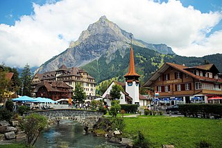
Kandersteg is a municipality in the Frutigen-Niedersimmental administrative district in the canton of Bern in Switzerland. It is located along the valley of the River Kander, west of the Jungfrau massif. It is noted for its spectacular mountain scenery and sylvan alpine landscapes. Tourism is a very significant part of its economic life today. It offers outdoor activities year-round, with hiking trails and mountain climbing as well as downhill and cross-country skiing. Kandersteg hosted the ski jumping and Nordic combined parts of the 2018 Nordic Junior World Ski Championships.

Grindelwald is a village and municipality in the Interlaken-Oberhasli administrative district in the canton of Berne. In addition to the village of Grindelwald, the municipality also includes the settlements of Alpiglen, Burglauenen, Grund, Itramen, Mühlebach, Schwendi, Tschingelberg and Wargistal.
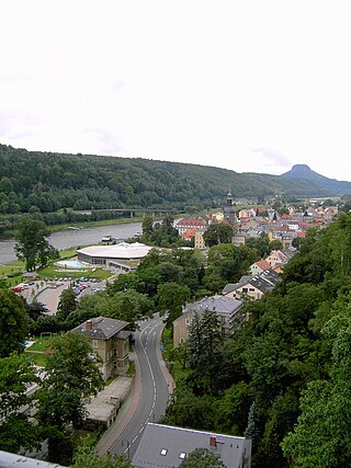
Bad Schandau is a spa town in Germany, in the Sächsische Schweiz-Osterzgebirge district of Saxony. It is situated on the right bank of the Elbe, at the mouth of the valley of the Kirnitzsch and in the area often described as Saxon Switzerland.
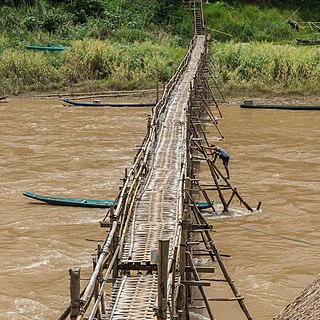
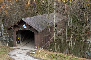
A footbridge is a bridge designed solely for pedestrians. While the primary meaning for a bridge is a structure which links "two points at a height above the ground", a footbridge can also be a lower structure, such as a boardwalk, that enables pedestrians to cross wet, fragile, or marshy land. Bridges range from stepping stones–possibly the earliest man-made structure to "bridge" water–to elaborate steel structures. Another early bridge would have been simply a fallen tree. In some cases a footbridge can be both functional and artistic.

The Grimsel Pass is a mountain pass in Switzerland, crossing the Bernese Alps at an elevation of 2,164 metres (7,100 ft). The pass connects the Haslital, the upper valley of the river Aare, with the upper valley of the Rhône. In so doing, and as the Aare is a tributary of the Rhine, the pass crosses the continental divide between the North Sea and the Mediterranean Sea.

The Bernese Oberland, the highest and southernmost part of the canton of Bern, is one of the canton's five administrative regions. It constitutes the Alpine region of the canton and the northern side of the Bernese Alps, including many of its highest peaks, among which the Finsteraarhorn, the highest in both range and canton.
Highway 16 is a provincial highway in the Canadian province of Saskatchewan. It is the Saskatchewan section of the Yellowhead Highway, and also the Trans-Canada Highway Yellowhead section. The main purpose of this highway is to connect Saskatchewan with Canadian cities such as Edmonton and Winnipeg. The highway runs from the Alberta boundary in Lloydminster to the Manitoba boundary near Marchwell. Major cities it passes through are Saskatoon, North Battleford in the central part of the province, Yorkton in the far east and Lloydminster to the far west.

Alexandre Calame was a Swiss landscape painter, associated with the Düsseldorf School.
Innertkirchen is a village and municipality in the Interlaken-Oberhasli administrative district in the canton of Bern in Switzerland. On 1 January 2014 the former municipality of Gadmen merged into the municipality of Innertkirchen.

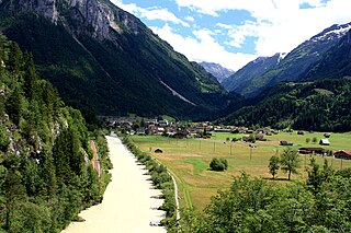
Guttannen is a municipality in the Interlaken-Oberhasli administrative district in the canton of Bern in Switzerland.

Magnetawan is a township in the Almaguin Highlands region of the Parry Sound District in the Canadian province of Ontario, as well as the name of the primary population centre in the township.

The Oberhasli is a historical Landvogtei or Talschaft in the Bernese Highlands, Switzerland, bordering on the cantons of Obwalden (OW), Nidwalden (NW), Uri (UR) and Wallis (VS).

Rüti is a village, and former municipality, in the municipality of Glarus Süd and canton of Glarus in Switzerland.

Tourists are drawn to Switzerland's diverse landscape as well as the available activities, which take advantage of the Alpine climate and landscapes, in particular skiing and mountaineering.

The Rapperswil Seedamm is the partially artificial causeway and bridge at the most narrow area of Lake Zurich, between Hurden (SZ) and Rapperswil (SG). The Seedamm carries a road and a railway across the lake, with the railway being used by the S5 and S40 lines of the S-Bahn Zürich and by the Südostbahn Voralpen Express.
Sihlbrugg is a village and important transportation node between the cantons of Zug (ZG) and Zürich (ZH) in Switzerland.


