
Farm Island Township is a township in Aitkin County, Minnesota, United States. The population was 1,099 as of the 2010 census.

Savannah Township is a township in Becker County, Minnesota, United States. The population was 162 as of the 2000 census.
Barnum Township is a township in Carlton County, Minnesota, United States. The population was 978 as of the 2000 census. Barnum Township was named for George G. Barnum, a railroad official.

Lake Itasca is a small glacial lake approximately 1.8 square miles in area. It is notable for being the headwaters of the Mississippi River, and is located in southeastern Clearwater County, in the Headwaters area of north central Minnesota. The lake is within Itasca State Park and has an average depth of 20 to 35 feet (6–11 m), and is 1,475 ft (450 m) above sea level.
Elkhorn or Elk Horn may refer to:
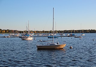
Bde Maka Ska is the largest lake in Minneapolis, Minnesota, United States, and part of the city's Chain of Lakes. Surrounded by city park land and circled by bike and walking trails, it is popular for many outdoor activities. The lake has an area of 401 acres (1.62 km2) and a maximum depth of 87 feet (27 m).
Bachelor Lake is a lake in Brown County, Minnesota in the northeastern part of Stark township. Covering 79.80 acres, it is an officially protected water of the State of Minnesota. The lake is within the Cottonwood River Major Watershed. The lake’s elevation is 1,004 feet (306 m), and it is zoned as a shoreland area which is regulated as a shoreland management water.

Temperance River State Park is a state park of Minnesota, USA, located between the communities of Schroeder and Tofte on Highway 61 on the North Shore of Lake Superior. It has campsites, picnic areas, and hiking trails on both sides of the Temperance River.
Fairbanks is an unincorporated community in Fairbanks Township, Saint Louis County, Minnesota, United States; located within the Superior National Forest.
Central Lakes is an unincorporated community in Saint Louis County, Minnesota, United States.
Greaney is an unincorporated community in Saint Louis County, Minnesota, United States. Greaney is located within ZIP code 55771 based in Orr.
Skibo is an unincorporated community in Bassett Township, Saint Louis County, Minnesota, United States.
Big Sandy Lake is a lake in Aitkin County, Minnesota, approximately nine miles north of McGregor. The lake is considered fertile walleye ground with several habitat types, including the open main basin, the deep, cold eastern basin, and a shallow, more isolated south basin. Shallow bays containing dense beds of wild rice are found on south, west, and northwest sides of the lake.
Zetland Glacier is a small hanging glacier on the southern slopes of Mount Alexandra in Denton Hills, Scott Coast. The glacier terminates on the cliffs north of Colleen Lake. The name, applied by New Zealand Geographic Board (NZGB) in 1994, is taken from an old spelling for the Shetland Islands of Scotland.
The Moose Horn River is a 36.4-mile-long (58.6 km) tributary of the Kettle River in eastern Minnesota, United States. It is part of the St. Croix River watershed, flowing eventually to the Mississippi River. It rises at the outlet of Wild River Lake, 7 miles (11 km) southwest of the city of Cloquet, and flows southwest through Carlton County, roughly parallel to Interstate 35. The river passes the communities of Mahtowa, Barnum, and Moose Lake, ending at the Kettle River southwest of the city of Sturgeon Lake.
The Portage River is an 8.8-mile-long (14.2 km) tributary of the Moose Horn River in eastern Minnesota, United States. It flows west to the Moose Horn River, joining it at Moosehead Lake next to the city of Moose Lake. By the Moose Horn River, its waters flow to the Kettle River, St. Croix River, and ultimately the Mississippi River. Just to the east of the Portage River, Nemadji Creek flows east to the Nemadji River, a tributary of Lake Superior and part of the Saint Lawrence River basin.
Cow Horn Lake is a lake in Itasca County, in the U.S. state of Minnesota and is found at an elevation of 1,280 feet (390 m).
Wall Lake is an unincorporated community in Otter Tail County, in the U.S. state of Minnesota.
