Placerville is a city in and the county seat of El Dorado County, California. The population was 10,747 as of the 2020 census, up from 10,389 as of the 2010 census. It is part of the Sacramento–Arden-Arcade–Roseville Metropolitan Statistical Area.

Pollock Pines is a census-designated place (CDP) in El Dorado County, California, United States. It is part of the Sacramento–Arden-Arcade–Roseville Metropolitan Statistical Area. Pollock Pines lies at an elevation of 3,980 feet (1,210 m) in the Sierra Nevada. The population was 7,112 at the 2020 census, up from 6,871 at the 2010 census.

The Native Sons of the Golden West is a fraternal service organization founded in the U.S. state of California in 1875, dedicated to historic preservation and documentation of the state's historic structures and places, the placement of historic plaques, and other charitable functions in California. In 1890 they placed California's first marker honoring the discovery of gold, which gave rise to the state nickname "The Golden State". U.S. President Richard M. Nixon and Chief Justice Earl Warren were NSGW presidents.

State Route 49 is a north–south state highway in the U.S. state of California that passes through many historic mining communities of the 1849 California gold rush and it is known as the Golden Chain Highway. The highway's creation was lobbied by the Mother Lode Highway Association, a group of locals and historians seeking a single highway to connect many relevant locations along the Gold Rush to honor the 49ers. One of the bridges along SR 49 is named for the leader of the association, Archie Stevenot.

Marshall Gold Discovery State Historic Park is a state park of California, United States, marking the discovery of gold by James W. Marshall at Sutter's Mill in 1848, sparking the California Gold Rush. The park grounds include much of the historic town of Coloma, California, which is now considered a ghost town as well as a National Historic Landmark District. The park contains thre California Historical Landmarks: a monument to commemorate James Marshall (#143), the actual spot where he first discovered gold in 1848 (#530). Established in 1942, and Coloma Road (#748),. The park now comprises 576 acres (233 ha) in El Dorado County.
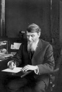
John Mohler Studebaker was the Pennsylvania Dutch co-founder and later executive of what would become the Studebaker Corporation automobile company. He was the third son of the founding Studebaker family, and played a key role in the growth of the company during his years as president, from 1868 until his death in 1917.

Hangtown fry is a type of omelette made famous during the California Gold Rush in the 1850s. The most common version includes bacon and oysters combined with eggs, and fried together.
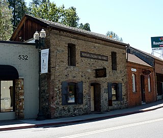
The Fountain-Tallman Soda Works is a historic building in Placerville, El Dorado County, California. It currently houses the Fountain & Tallman Museum, which is owned and operated by the El Dorado County Historical Society. The rustic vernacular Victorian stone and brick building, of the Gold Country, was placed on the National Register of Historic Places on September 13, 1984.

The El Dorado County Fair is held in Placerville, California, every Father's Day weekend. The annual event opens on the third Thursday in June and concludes on the following Sunday evening.

Swansboro Country; a subdivision within the community of Mosquito, is a residential area northeast of Placerville, the county seat of El Dorado County, California. The population was approximately 1,000 at the 2010 census. It is part of the Sacramento–Arden-Arcade–Roseville Metropolitan Statistical Area.
Alexander Howison Murray Jr. (1907–1993), known as Sandy Murray, was a two-time mayor of Placerville, California and three-time president of the county's chamber of commerce, who championed regional development, including the building of U.S. Route 50 in California (US 50) and was a regular page-one name in the Placerville Mountain Democrat.
Lloyd Raffetto also known as Lloyd A. Raffetto, Lloyd Alexander Raffetto, and "Raff" (1897-1988), was a noted Italian-American-Irish-American co-inventor of an ice cream manufacturing process, entrepreneur, and banker who owned the Raffles Hotel and co-founded the Mother Lode Bank, both of Placerville, California.
Jackson Pioneer Jewish Cemetery, also known as Givoth Olam, is a no longer active Jewish cemetery founded in 1857 by the Congregation B'nai Israel, and is located in Jackson, Amador County, California. By 1921, the cemetery was closed.
Methodist Episcopal Church in Placerville, California is a California Historical Landmark No. 767. The Methodist Episcopal Church was built in 1851 in El Dorado County, California. Methodist Episcopal Church is the oldest church building in El Dorado County. The Church building was moved to its current location from its original site on the corner of Cedar Ravine and Main Street, Placerville 38.7287°N 120.796°W. The roof support beams were hand-made from local ponderosa pine trees. Methodist Episcopal Church's first bell tower bell was purchased from the sailing ship Staffordshire. A historical marker was placed and dedicated by the El Dorado County Chamber of Commerce in 1961 and re-dedicated in 1996.

Pleasant Grove House Pony Express Station is a historical building in Rescue, California built in 1850. The site of the Pleasant Grove House Pony Express Station is a California Historical Landmark No. 703. The historical building was built to house California Gold Rush 49 miners traveling to find gold and stake a claim. The Pleasant Grove House Pony Express Station in El Dorado County, California. At the Pleasant Grove House Pony Express Station, Pony Express riders would change horses. The Pleasant Grove House Pony Express Station was used for the Central Overland California and Pikes Peak Express Company's Pony Express Service from July 1, 1860, to June 30, 1861. From the Pleasant Grove House Pony Express Station, the riders heading west would go to Folsom. Riders heading east rode to Placerville traveling through the Rescue, Dry Creek Crossing, and Missouri Flat.