Related Research Articles

Washington County is a county located in the U.S. state of Tennessee. As of the 2020 census, the population was 133,001. Its county seat is Jonesborough. The county's largest city and a regional educational, medical and commercial center is Johnson City. Washington County is Tennessee's oldest county, having been established in 1777 when the state was still part of North Carolina. Washington County is part of the Johnson City, TN Metropolitan Statistical Area, which is a component of the Johnson City–Kingsport–Bristol, TN-VA Combined Statistical Area, commonly known as the "Tri-Cities" region.

Carter County is a county located in the U.S. state of Tennessee. As of the 2020 census, the population was 56,356. Its county seat is Elizabethton. The county is named in honor of Landon Carter (1760–1800), an early settler active in the "Lost State of Franklin" 1784-1788 secession from the State of North Carolina. Carter County is part of the Johnson City, TN Metropolitan Statistical Area, which is a component of the Johnson City–Kingsport–Bristol, TN-VA Combined Statistical Area, located in northeastern Tennessee.
Central is an unincorporated community and census-designated place (CDP) in western Carter County, Tennessee, United States. The population was 2,717 at the 2000 census and 2,279 at the 2010 census. It is part of the Johnson City Metropolitan Statistical Area, which is a component of the Johnson City–Kingsport–Bristol, TN-VA Combined Statistical Area – commonly known as the "Tri-Cities" region.

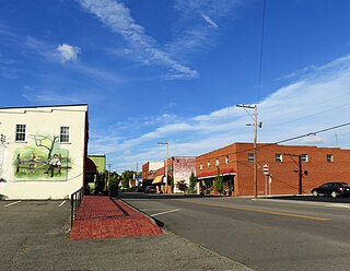
Elizabethton is a city in, and the county seat of Carter County, Tennessee, United States. Elizabethton is the historical site of the first independent American government located west of both the Eastern Continental Divide and the original Thirteen Colonies.
Hunter is a census-designated place (CDP) and unincorporated community located northeast of Elizabethton in Carter County, Tennessee, along Tennessee State Route 91 and the Watauga River. Its population was 1,854 as of the 2010 census. It is part of the Johnson City Metropolitan Statistical Area, which is a component of the Johnson City-Kingsport-Bristol, TN-VA Combined Statistical Area – commonly known as the "Tri-Cities" region. Hunter is a suburb of Elizabethton.

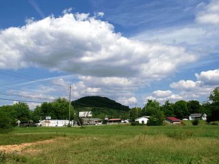
Roan Mountain is a census-designated place (CDP) in Carter County, Tennessee, United States. The population was 1,360 at the 2010 census. It is part of the Johnson City Metropolitan Statistical Area, which is a component of the Johnson City–Kingsport–Bristol, TN-VA Combined Statistical Area – commonly known as the Tri-Cities region.

Church Hill is a city in Hawkins County, Tennessee, United States. The population was 6,998 at the 2020 census and 6,737 at the 2010 census. It is part of the Kingsport-Bristol-Bristol, TN-VA Metropolitan Statistical Area, which is a component of the "Tri-Cities" region. It is the largest municipality located entirely within Hawkins County.
Mountain City is a town in and the county seat of Johnson County, Tennessee, United States. The population was 2,415 at the 2020 census. It is the northeasternmost county seat in Tennessee. In addition, at an elevation of 2,418 feet (737 m), it has the distinction of being the highest incorporated city in the state.

Watauga is a city in Carter and Washington counties in the U.S. state of Tennessee. The population was 403 at the 2000 census, 458 at the 2010 census, 361 in the 2020 census. It is part of the Johnson City Metropolitan Statistical Area, which is a component of the Johnson City-Kingsport-Bristol, TN-VA Combined Statistical Area – commonly known as the "Tri-Cities" region.
The Little Doe River is a river located in Carter County, Tennessee. It forms from the confluence of Simerly Creek and Tiger Creek near the community of Tiger Valley, and runs in a northerly direction alongside U.S. Route 19E until its termination into Doe River just south of the town of Hampton, Tennessee.

The Doe River is a tributary of the Watauga River in northeast Tennessee in the United States. The river forms in Carter County near the North Carolina line, just south of Roan Mountain State Park, and flows to Elizabethton.
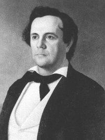
Nathaniel Green Taylor was an American lawyer, farmer, and politician from Tennessee. He was U.S. Representative from Tennessee from 1854 to 1855, and again from 1866 to 1867, and Commissioner of Indian Affairs from 1867 to 1869.

Dayton E. Phillips was an American politician and a member of the United States House of Representatives for the 1st congressional district of Tennessee.
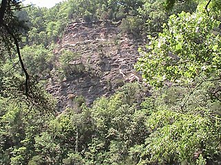
The Bee Cliff is a prominent northeast Tennessee geological limestone feature with high caves that overlooks the Watauga River and the Siam community of Carter County, Tennessee.

Sycamore Shoals State Historic Park is a state park located in Elizabethton, in the U.S. state of Tennessee. The park consists of 70 acres (28.3 ha) situated along the Sycamore Shoals of the Watauga River, a National Historic Landmark where a series of events critical to the establishment of the states of Tennessee and Kentucky, and the settlement of the Trans-Appalachian frontier in general, took place. Along with the historic shoals, the park includes a visitor center and museum, the reconstructed Fort Watauga, the Carter House and Sabine Hill . For over a thousand years before the arrival of European explorers, Sycamore Shoals and adjacent lands had been inhabited by Native Americans. The first permanent European settlers arrived in 1770, and established the Watauga Association—one of the first written constitutional governments west of the Appalachian Mountains—in 1772. Richard Henderson and Daniel Boone negotiated the Treaty of Sycamore Shoals in 1775, which saw the sale of millions of acres of Cherokee lands in Kentucky and Tennessee and led to the building of the Wilderness Road. During the American Revolution, Sycamore Shoals was both the site of Fort Watauga, where part of a Cherokee invasion was thwarted in 1776, and the mustering ground for the Overmountain Men in 1780.

Sabine Hill, also known as Happy Valley, Watauga Point, and the General Nathaniel Taylor House, is a historic house in Elizabethton, Tennessee. The two-story Federal style building was listed on the National Register of Historic Places in 1973. It is an excellent example of federal architecture. It was threatened by demolition in 2007 when the owners sought to have the property rezoned for apartments. The rezoning request was denied and the home was bought by several preservation-minded locals who secured it until the State of Tennessee/Tennessee Historical Commission could purchase the museum-quality property. It is now restored and opened to the public on November 1, 2017, as a unit of Sycamore Shoals State Park. The property is operated by the Park under a memorandum of understanding with the Tennessee Historical Commission.
Valley Forge is an unincorporated community in Carter County, Tennessee. Located along US Route 19E/321 and SR-67, south of Elizabethton and north of Hampton.
Milligan College is an unincorporated community and an area of Elizabethton, in Carter County, Tennessee. Milligan is home to Milligan University and Emmanuel Christian Seminary. All of Milligan has been annexed by the city of Elizabethton.
Tiger Valley is an unincorporated community in Carter County, Tennessee that is located on Tennessee State Route 173 at its junction with U.S. Route 19E. Tiger Valley is located south of Elizabethton, the county seat of Carter County, and north of Roan Mountain.
Holston Valley is an unincorporated community in eastern Sullivan County, Tennessee, United States. Holston Valley is located along U.S. Route 421 and State Route 44 southeast of Bristol.
References
- ↑ Cox, W. Eugene; Cox, Joyce (2011). An American Saga: Some East Tennessee Taylors. iUniverse. p. 17. ISBN 9781462043439.
- ↑ "Schools". Carter County Board of Education. Archived from the original on 2014-02-19.