Haraldssund | |
|---|---|
Village | |
 Haraldssund | |
 Haraldssund Location in the Faroe Islands | |
| Coordinates: 62°16′20″N6°36′7″W / 62.27222°N 6.60194°W | |
| State | |
| Constituent country | |
| Island | Kunoy |
| Municipality | Kunoyar |
| Population (September 2025) [1] | |
• Total | 69 |
| Time zone | GMT |
| • Summer (DST) | UTC+1 (EST) |
| Postal code | FO 785 |
| Climate | Cfc |
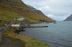
Haraldssund (Danish : Haraldsund) is a settlement in the Faroe Islands, situated on the island of Kunoy.
Contents
Haraldssund is located on the east coast of Kunoy and is connected to the village of Kunoy on the west coast by a tunnel. To the east, it is linked to the town of Klaksvík on Borðoy by a causeway. The tunnel and the causeway were built in the late 1980s.

Two kilometers south of the village is a small ruin.