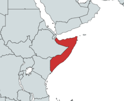
Somalia is a country located in the Horn of Africa which officially consists of the intra-46th meridian east territory, the seven federal member states, namely Galmudug, Hirshabelle, Jubaland, South West, Puntland, and the municipality of Benadir. It is bordered by Ethiopia to the west, the Gulf of Aden to the north, the Somali Sea and Guardafui Channel to the east, and Kenya to the southwest. With a land area of 637,657 square kilometers, Somalia's terrain consists mainly of plateaus, plains and highlands. Its coastline is more than 3,333 kilometers in length, the longest of mainland Africa. It has been described as being roughly shaped "like a tilted number seven".

Bay is an administrative region (gobol) in southern Somalia.
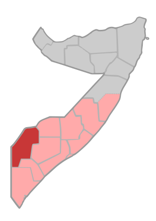
Gedo is an administrative region (gobol) in Jubaland, southern Somalia. Its regional capital is Garbahaarreey. It was created in 1974 and is bordered by the Ogaden in Ethiopia, the North Eastern Province in Kenya, and the Somali regions of Bakool, Bay, Jubbada Dhexe, and Jubbada Hoose further down east. The southern parts of Gedo, west of the Jubba River, used to be part of the old British Trans-Juba region during half of the seventy years of colonial era in Africa from 1890 to 1960. The British and Italians fought twice over this area. The first democratically elected governor of the administrative region was Hussein Farey, who entered office in 2008.

Middle Juba is an administrative region (gobol) in southern Somalia. With its capital at Bu'aale, it is located in the autonomous Jubaland region.

Lower Juba is an administrative region (gobol) in southern Somalia. With its capital at Kismayo, it lies in the autonomous Jubaland region. It has green forests and wildlife including lions, giraffes, hippos, crocodiles, and hyenas.
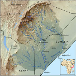
The Jubba River or Juba River is a river in southern Somalia which flows through the autonomous region of Jubaland. It begins at the border with Ethiopia, where the Dawa and Ganale Dorya rivers meet, and flows directly south to the Somali Sea, where it empties at the Goobweyn juncture. The Jubba basin covers an area of 749,000 km2 (289,000 sq mi). The Somali regional state of Jubaland, formerly called Trans-Juba, is named after the river.
Kismayo is a port city in the southern Lower Juba province of Somalia. It is the commercial capital of the autonomous Jubaland region.
Barre Adan Shire, also known as Barre Hiiraale, Barre "Hirale" Aden Shire, or Abdikadir Adan Shire, is a former Minister of Defense of the Somali Transitional Federal Government (TFG). He was previously the TFG Minister for National Reconstruction and Resettlement. Hiiraale was also the chairman of the now defunct Juba Valley Alliance, which controlled Southern and Southwestern Somalia, including the nation's third-largest city, the strategic port town of Kismayo. During his time in office, Hiiraale presided over the country's largest autonomous area, as well as commanding an extensive militia.
The Garre are a prominent Somali clan that traces its lineage back to Samaale, who is believed to have originated from the Arabian Peninsula through Aqiil Abu Talib. The Garre clan is considered to be a sub-clan of the Digil-Rahanweyn clan family, which is part of the larger Rahanweyn clan. However, genealogically, they are descended from Gardheere Samaale. The Garre are also categorized as southern Hawiye as well.

Bardere also known as Bardera, is a city in Jubaland State of Somalia. It is the second largest and most populous city in Jubaland with Kismayo being the largest and most densely populated city in the region. Bardere sits on the Jubba River around 250 km west of the city of Baidoa and is in a highland area with fertile soil.
The Juba Valley Alliance is a political faction of the Somali Civil War. It was the primary opponent of the Somali Patriotic Movement (SPM) and the Somali Reconciliation and Restoration Council (SRRC) vying for the control of Kismayo and the Juba River valley, the area known as Jubaland.

The Battle of Jilib took place during the 2006 Somali War fought by the Islamic Courts Union (ICU) and affiliated militias against Ethiopian and Transitional Federal Government (TFG) forces for control of the town of Jilib. It began on 31 December 2006, when ICU forces dug in and defended the town to prevent approach to Kismayo, the last stronghold of the ICU.
Jilib is a city in the Middle Juba region of Somalia. It has an estimated population of around 100,000 inhabitants and covers an area of about 10 square kilometres. It is 112 kilometres or 70 miles north of Kismaayo.
The fall of Kismayo occurred on January 1, 2007, when the troops of Somalia's Transitional Federal Government (TFG) and Ethiopian forces entered the Somali city of Kismayo unopposed. It came after the Islamic Courts Union's forces faltered and fled in the Battle of Jilib, abandoning their final stronghold.

Bardera Polytechnic is a non-profit tertiary polytechnic education centre located in Bardera, Somalia. The college's full name is Bardera Polytechnic College (BPC). Bardera Polytechnic is the first post-secondary institution in Bardera and the larger Gedo region. Bardera Polytechnic is the first post civil war vocational training school in southern Somalia.
Bu'ale or Bu'aale is an agricultural city located in Middle Juba region of Somalia and the capital city of Jubaland state of Somalia.
Juba Valley Veterinary Institute or Af Somali Kuliyada Xanaanada Xoolaha ee Dooxada Juba, Arabic:, Italian: Giuba Valle Veterinario Instituto is a veterinary institute in Bardera, Gedo Somalia. The Institute is part of Bardera Polytechnic specialized schools and institutes within the college system.
Uar Esgudud or is a small village in southeast Gedo region in the District of Bardera. The village sits right at the cross-roads of the districts of Bardera, Afmadow and Sakow of the regions Gedo, Lower Juba and Middle Juba, respectively. War Caws Gadudud Village coordinates are Latitide 1° 16' (1.2667°) north; Longitude 41° 23' (41.3833°) east.
Agriculture in Somalia is a major employment activity and is the largest economic sector in the country. It contributes more than 65% to the national GDP from domestic distribution and exports to other parts of the continent, the Middle East and Europe.

This is a 2014 timeline of events in the Somali Civil War (2009–present).
