
Bradford Woods is a borough in Allegheny County, Pennsylvania, United States. The population was 1,183 at the 2020 census. A suburb of the Pittsburgh metropolitan area, it is part of the North Allegheny School District and participates in the multi-municipality Northland Public Library. It is home to Bradford Woods Elementary School.

Ambridge is a borough in Beaver County, Pennsylvania, United States. Incorporated in 1905 as a company town by the American Bridge Company, Ambridge is located 16 miles (25 km) northwest of Pittsburgh, along the Ohio River. The population was 6,972 at the 2020 census.

Economy is a borough in Beaver County, Pennsylvania, United States. The population was 9,098 at the 2020 census. It is a part of the Pittsburgh metropolitan area.
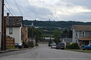
Freedom is a borough in Beaver County, Pennsylvania, United States, along the Ohio River. The population was 1,496 at the 2020 census. It is located 25 miles (40 km) northwest of Pittsburgh and is part of the Pittsburgh metropolitan area. Originally founded as a steamboat building town, chief industries later included the production of oil, caskets, and monuments.

Monaca is a borough in Beaver County, Pennsylvania, United States, along the Ohio River. The population was 5,625 as of the 2020 census. It is located 25 miles (40 km) northwest of Pittsburgh and is part of the Pittsburgh metropolitan area.

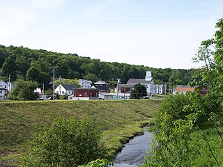
Hamburg is a borough in Berks County, Pennsylvania, United States. The population was 4,270 at the 2020 census. The town is thought to have been named after Hamburg, Germany, but this is likely to have been a corruption of Bad Homburg.
Valencia is a borough in Butler County, Pennsylvania, United States. The population was 551 at the 2010 census.

Cresson is a borough in Cambria County, Pennsylvania, United States. Cresson is 80 miles (130 km) east of Pittsburgh. It is above 2,000 feet (600 m) in elevation. Lumber, coal, and coke yards were industries that had supported the population, which numbered 1,470 in 1910. The borough is part of the Johnstown Metropolitan Statistical Area, although state and local sources list it as part of the Altoona area due to being much closer to that city. The population of Cresson at the 2010 census was 1,711.

Northern Cambria is a borough in Cambria County, Pennsylvania, United States. It is part of the Johnstown, Pennsylvania Metropolitan Statistical Area. The population was 3,835 at the 2010 census.
Richland Township is a township in Cambria County, Pennsylvania, United States. The population was 12,814 at the 2010 census. It is part of the Johnstown, Pennsylvania Metropolitan Statistical Area.

Ridgway is a borough in and the county seat of Elk County, Pennsylvania. As of the 2020 census it had a population of 4,039
Cherry Tree is a borough in Indiana County, Pennsylvania, United States. The population was 276 at the 2020 census.

Wind Gap is a borough in Northampton County, Pennsylvania. The population of Wind Gap was 2,820 at the 2020 census. Wind Gap is part of the Lehigh Valley metropolitan area, which had a population of 861,899 and was the 68th-most populous metropolitan area in the U.S. as of the 2020 census.

Donegal is a borough in Westmoreland County, Pennsylvania, United States. It is a distinct municipality from the adjacent Donegal Township. The population was 103 at the 2020 census. Donegal is best known as an exit on the Pennsylvania Turnpike with restaurants, gas stations, and two hotels for travelers.

Philipsburg is a borough in Centre County, Pennsylvania. It is located at 40°53′42″N78°13′09″W. It is part of the State College, Pennsylvania metropolitan statistical area. The borough's population was 2,770 at the 2010 census.
Barnesboro, Pennsylvania was a borough located in Cambria County, Pennsylvania, United States.

The Huntingdon Area School District, commonly abbreviated HASD, is a midsized rural public school district based in the borough of Huntingdon, Pennsylvania. The school district includes all of Huntingdon borough, Brady Township, Smithfield Township, Henderson Township, Juniata Township, Walker Township, Oneida Township, Penn Township, Marklesburg borough, Jackson Township, Mill Creek borough, Miller Township, and Lincoln Township. The district encompasses approximately 286 square miles (740 km2). The school's mascot is the bearcat. The school's official colors are red and blue.
Windber Area High School is a public High School on the Somerset-Cambria County Border, serving students from the Somerset County borough of Windber and Paint Borough in Cambria County. WAHS's feeder school, Windber Area Middle School is connected directly to the high school.

Curwensville Area Junior/Senior High School is a public high school located in the borough of Curwensville, Pennsylvania, United States. It serves students from most of south central Clearfield County. The school is part of the Curwensville Area School District. In the 2018–2019 school year there ere 480 students at the school.

The Ferndale Area Junior-Senior High School is a public high school, located at 600 Harlan Avenue, Ferndale, Cambria County, Pennsylvania. It serves the boroughs of Brownstown, Dale and Lorain as well as Middle Taylor Township. In 2014, Ferndale Area Junior Senior High School's enrollment was reported as 337 pupils in 7th through 12th grades. The current high school buildings opened in 1931 and 1938 and were renovated between 1978 and 1979. They also have had a couple different renovation projects over the years.

