Harper's Grove – Lord's Grove

Last updated
Harper's Grove – Lord's Grove
Site of Special Scientific Interest

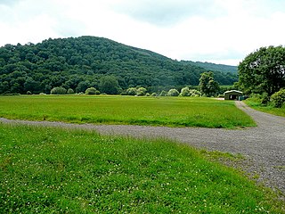
Upper Beaulieu Farm and Lord's Grove - geograph.org.uk - 606574.jpg

Upper Beaulieu Farm and Lord's Grove
Monmouthshire UK location map.svg
Red pog.svg
Location within Monmouthshire
Area of Search Monmouthshire
Grid reference SO528113
Coordinates 51°47′55″N2°41′05″W / 51.7987°N 2.6848°W / 51.7987; -2.6848 Coordinates: 51°47′55″N2°41′05″W / 51.7987°N 2.6848°W / 51.7987; -2.6848
Interest Biological
Area 22.2 hectares (0.222 km2; 0.0857 sq mi)
Notification 1981

Harper's Grove – Lord's Grove is a Site of Special Scientific Interest (SSSI), noted for its biological characteristics, in Monmouthshire, south east Wales. [1]

Site of Special Scientific Interest Conservation designation denoting a protected area in the United Kingdom

A Site of Special Scientific Interest (SSSI) in Great Britain or an Area of Special Scientific Interest (ASSI) in the Isle of Man and Northern Ireland is a conservation designation denoting a protected area in the United Kingdom and Isle of Man. SSSI/ASSIs are the basic building block of site-based nature conservation legislation and most other legal nature/geological conservation designations in the United Kingdom are based upon them, including national nature reserves, Ramsar sites, Special Protection Areas, and Special Areas of Conservation. The acronym "SSSI" is often pronounced "triple-S I".

Monmouthshire County

Monmouthshire is a county in south-east Wales. The name derives from the historic county of Monmouthshire of which it covers the eastern 60%. The largest town is Abergavenny. Other towns and large villages are Caldicot, Chepstow, Monmouth, Magor and Usk. It borders Torfaen and Newport to the west; Herefordshire and Gloucestershire to the east; and Powys to the north.

Wales Country in northwest Europe, part of the United Kingdom

Wales is a country that is part of the United Kingdom and the island of Great Britain. It is bordered by England to the east, the Irish Sea to the north and west, and the Bristol Channel to the south. It had a population in 2011 of 3,063,456 and has a total area of 20,779 km2 (8,023 sq mi). Wales has over 1,680 miles (2,700 km) of coastline and is largely mountainous, with its higher peaks in the north and central areas, including Snowdon, its highest summit. The country lies within the north temperate zone and has a changeable, maritime climate.

Contents

Geography

The 22.2-hectare (55-acre) SSSI, notified in 1981, is located within the community of Monmouth, being 1.5 miles (2.4 km) south-west of the town of the same name. [2] [3]

A community is a division of land in Wales that forms the lowest tier of local government in Wales. Welsh communities are analogous to civil parishes in England. In 2016 there were 870 communities in Wales.

Related Research Articles

Llangathen village in United Kingdom

Llangathen is a community located in Carmarthenshire, Wales. The population taken at the 2011 census was 507.

Fiddlers Elbow National Nature Reserve nature reserve in Monmouth, Wales

Fiddler’s Elbow National Nature Reserve is a steep sided, woodland national nature reserve of 45 hectares in the Upper Wye Valley to the north of Monmouth in Wales, close to the Wales–England border. It is designated as a Site of Special Scientific Interest (SSSI) for its biological characteristics, containing a wide variety of flora.

Allt y wern

Allt y Wern is a Site of Special Scientific Interest (SSSI) in the community of Llangathen in Carmarthenshire, Wales. The site is a semi-natural broadleaved woodland with an area of 6 hectares.

Elenydd

Elenydd is an upland area of west-central Wales, extending across parts of northern and eastern Ceredigion and Powys between Aberystwyth and Rhayader. Elenydd is also a name given to the medieval commote of Cwmwd Deuddwr which covered approximately the same area.

Caer Llan is a field studies centre, conference centre and former country house located at Lydart within the community of Mitchel Troy, Monmouthshire, south east Wales, about 3 miles (4.8 km) south-west of Monmouth. It is close to the top of a scarp slope with extensive views westwards over the valley of the River Trothy, and is accessed from the B4293 road.

Croes Robert Wood

Croes Robert Wood is a nature reserve and Site of Special Scientific Interest (SSSI), noted for its biological characteristics, in Monmouthshire, south east Wales. Gwent Wildlife Trust, the owners of the site, manage the woodland through methods of coppicing and charcoal burning to encourage its notable flora and fauna.

Gaer Wood

Gaer Wood is a Site of Special Scientific Interest (SSSI), noted for its biological characteristics, in Monmouthshire, south east Wales.

Graig Wood

Graig Wood is a Site of Special Scientific Interest (SSSI), noted for its biological characteristics, in Monmouthshire, south east Wales. It forms part of the wider Hael Woods complex.

Lydart village in United Kingdom

Lydart is a dispersed hamlet within the community of Mitchel Troy, Monmouthshire, Wales. It is located about 3 miles (4.8 km) south-west of Monmouth, 3 miles (4.8 km) north of Trellech, and 1 mile (1.6 km) south-east of Mitchel Troy village, on the top of an escarpment which slopes steeply down to the valley of the River Trothy. The B4293 road passes through the area.

Livox Wood

Livox Wood is a woodland and Site of Special Scientific Interest (SSSI), noted for its biological characteristics, in Monmouthshire, south east Wales.

Lower Hael Wood

Lower Hael Wood is a semi-ancient woodland and Site of Special Scientific Interest (SSSI), noted for its biological characteristics, in Monmouthshire, south east Wales. It is part of the wider Hael Woods complex. The wood is on the side of the River Wye which is the border between Wales and England.

Maes-yr-Uchaf Wood

Maes-yr-Uchaf Wood is a small woodland and Site of Special Scientific Interest (SSSI), noted for its biological characteristics, in Monmouthshire, south east Wales.

Newton Court building in Monmouth, Wales

Newton Court is a neoclassical house, completed in 1802, situated on the hillside above Dixton, 1 mi (1.6 km) north-east of the town on Monmouth, in Monmouthshire, Wales. It is a Grade II* listed building. The stable block is listed as a Site of Special Scientific Interest (SSSI), noted for as a breeding site for lesser horseshoe bats.

Pentwyn Farm Grasslands

Pentwyn Farm Grasslands is a nature reserve, and a series of agricultural fields, in Monmouthshire, southeast Wales. It was designated a Site of Special Scientific Interest (SSSI) in 1993, noted for its biological characteristics.

Upper Wye Gorge

Upper Wye Gorge is a Site of Special Scientific Interest (SSSI), noted for its biological and geological characteristics, around Symonds Yat in the Upper Wye Valley on the Wales–England border. The site is listed in the 'Forest of Dean Local Plan Review' as a Key Wildlife Site (KWS).

References

  1. "Harper's Grove – Lord's Grove". Countryside Council for Wales . Retrieved 21 March 2012.[ permanent dead link ]
  2. "Harper's Grove – Lord's Grove map" (pdf). Countryside Council for Wales . Retrieved 21 March 2012.[ permanent dead link ]
  3. Ordnance Survey: Explorer map sheet OL14 Wye Valley & Forest of Dean ISBN   9780319240953