Related Research Articles

Burke is an unincorporated section of Fairfax County, Virginia, United States traditionally defined as the area served by the Burke post office. Burke includes two census-designated places: The Burke CDP, population 41,055 in 2010 and the Burke Centre CDP, population 17,326.

Stalybridge is a town in Tameside, Greater Manchester, England, with a population of 23,731 at the 2011 Census. Historically part of Cheshire, it is 8 miles (12.9 km) east of Manchester city centre and 6 miles (9.7 km) north-west of Glossop.

Stockport is a large town in Greater Manchester, England, 7 miles (11 km) south-east of Manchester city centre, where the River Goyt and Tame merge to create the River Mersey. It is the largest town in the metropolitan borough of the same name.

Ilam is a village in the Staffordshire Peak District of England, lying on the River Manifold. The population of the civil parish as taken at the 2011 census was 402.

Wilmslow Road is a major road in Manchester, England, running from Parrs Wood northwards to Rusholme. There it becomes Oxford Road and the name changes again to Oxford Street when it crosses the River Medlock and reaches the city centre.
Celbridge is a town and townland on the River Liffey in County Kildare, Ireland. It is 23 km (14 mi) west of Dublin. Both a local centre and a commuter town within the Greater Dublin Area, it is located at the intersection of the R403 and R405 regional roads. As of the 2016 census, Celbridge was the third largest town in County Kildare by population, with over 20,000 residents.
Woodley is a suburb in the Metropolitan Borough of Stockport, Greater Manchester, England, on the east side of the Peak Forest Canal, next to Bredbury and Romiley and the boundary with Gee Cross, Tameside.

Romiley is a village in the Metropolitan Borough of Stockport, Greater Manchester, England. Historically part of Cheshire, it borders Marple, Bredbury and Woodley. At the 2011 census, the Romiley ward, which includes Compstall, Bredbury Green and a large part of Bredbury, had a population of 14,139.

Hazel Grove is a constituency in Greater Manchester, England represented in the House of Commons of the UK Parliament since 2015 by William Wragg, a Conservative.

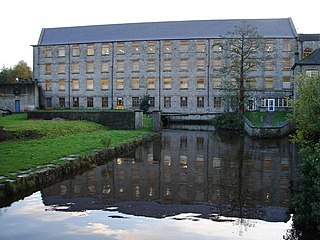
Bredbury is a town in the Metropolitan Borough of Stockport, Greater Manchester, England. It is situated 7.9 miles (12.7 km) south-east of Manchester, 1.8 miles (2.9 km) east of Stockport and 3.2 miles (5.1 km) south-west of Hyde. At the 2011 census, it had a population of 13,593.

Bamber Bridge railway station serves the area of Bamber Bridge, England 4 miles (6 km) to the south of Preston city centre on the A6 and M6 roads. It is situated on the East Lancashire Line and is managed by Northern.
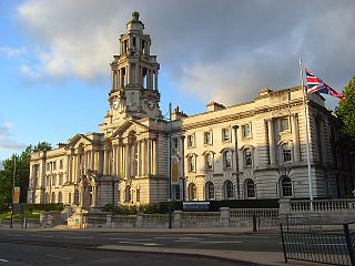
The Metropolitan Borough of Stockport is a metropolitan borough of Greater Manchester in North West England. As well as the town of Stockport, it includes the outlying areas of Bramhall, Cheadle, Cheadle Hulme, Marple, Bredbury, Reddish, Woodley and Romiley. In 2001, it had a population of 284,500.
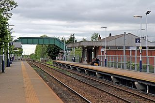
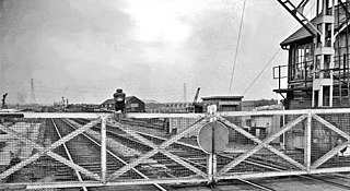
Bredbury railway station serves the town of Bredbury in the Metropolitan Borough of Stockport, Greater Manchester, England.

Bredbury and Romiley was an urban district in the administrative county of Cheshire, England from 1894 to 1974, which covered the civil parishes of Bredbury, Compstall and Romiley.
Stockport was a rural district in the administrative county of Cheshire from 1894 to 1904. The district was the successor to the Stockport Rural Sanitary District formed in 1875.
Beighton railway station is a former railway station near the village of Beighton on the border between Derbyshire and South Yorkshire, England.

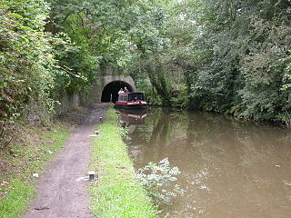
The Cheshire Ring is a canal cruising circuit or canal ring, which includes sections of six canals in and around Cheshire and Greater Manchester in North West England: the Ashton Canal, Peak Forest Canal, Macclesfield Canal, Trent and Mersey Canal, Bridgewater Canal and Rochdale Canal.
Holbrook Gaskell II was a chemical industrialist in Widnes, Lancashire, England.
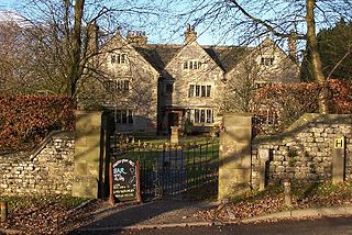
Hartington Hall is a much altered and extended 17th-century manor house at Hartington, Derbyshire, now a youth hostel.
References
- ↑ Burke, Bernard (1852). A visitation of the seats and arms of the noblemen and gentlemen of Great Britain. Colburn. p. 266.
- ↑ Burke, pp.266-7
- ↑ Burke, p.267
- 1 2 "Peak District View: Harrytown Hall". Peak District National Park. Retrieved 7 January 2010.
- ↑ Middleton, Thomas (1899). Annals of Hyde and district : containing historical reminiscences of Denton, Haughton, Dukinfield, Mottram, Longdendale, Bredbury, Marple, and the neighbouring townships. Cartwright & Rattray. p. 399.
Coordinates: 53°24′46″N2°06′18″W / 53.4127°N 2.1051°W
| | This article about a Greater Manchester building or structure is a stub. You can help Wikipedia by expanding it. |