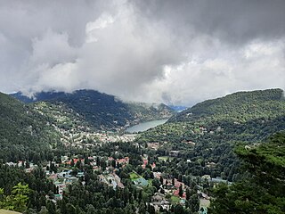
Nainital is a town and headquarters of Nainital district of Kumaon division, Uttarakhand, India. It is the judicial capital of Uttarakhand, the High Court of the state being located there and is the headquarters of an eponymous district. It also houses the Governor of Uttarakhand, who resides in the Raj Bhavan. Nainital was the summer capital of the United Provinces.
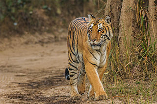
Jim Corbett National Park is a national park in India located in the Nainital district of Uttarakhand state. The first national park in India, it was established in 1936 during the British Raj and named Hailey National Park after William Malcolm Hailey, a governor of the United Provinces in which it was then located. In 1956, nearly a decade after India's independence, it was renamed Corbett National Park after the hunter and naturalist Jim Corbett, who had played a leading role in its establishment and had died the year before. The park was the first to come under the Project Tiger initiative.
Hartola is a municipality of Finland. It is located in the Itä-Häme, Päijänne Tavastia region. The municipality has a population of 2,531 (31 December 2023), which make it the smallest municipality in Päijänne Tavastia in terms of population. It covers an area of 675.38 square kilometres (260.77 sq mi) of which 132.18 km2 (51.03 sq mi) is water. The population density is 4.66 inhabitants per square kilometre (12.1/sq mi). Neighbouring municipalities are Heinola, Joutsa, Luhanka, Pertunmaa and Sysmä.

Kumaon is a revenue and administrative division in the Indian State of Uttarakhand. It spans over the eastern half of the state and is bounded on the north by Tibet, on the east by Nepal, on the south by the state of Uttar Pradesh, and on the west by Garhwal. Kumaon comprises six districts of the state: Almora, Bageshwar, Champawat, Nainital, Pithoragarh and Udham Singh Nagar.

Haldwani is the largest city of Kumaon. It is also the third most populous city and largest commercial market in the Indian state of Uttarakhand. Haldwani is said to be the financial capital of Uttarakhand, having the most commercial, economic and industrial activities of the state. Haldwani is located in the Nainital District, and is one of its eight Subdivisions. The Haldwani Urban agglomeration has 232,060 people as of 2011, and is the third most populous UA in Uttarakhand, after Dehradun and Haridwar. Being situated in the immediate foothills of Kumaon Himalayas, the Kathgodam neighbourhood of Haldwani is known as the "Gateway to Kumaon".

Mukteshwar is a village and tourist destination in the Nainital district of Uttarakhand, India. It sits high in the Kumaon Hills at an altitude of 2171 meters (7500 feet), 51 km from Nainital, 72 km from Haldwani, and 343 km from Delhi.

Kathgodam is a suburb of Haldwani city in the Nainital district of Uttarakhand state of India. It used to be a part of the twin township of Haldwani-Kathgodam, and is immediately north of Haldwani. It is one of the important collection centres for forest products obtained from Kumaon Himalayas.

Bhowali is a town and a municipal board in Nainital District in the state of Uttarakhand, India. It is situated at a distance of 11 km (6.8 mi) from the city of Nainital, the district headquarters; at an average elevation of 1,654 m (5,427 ft) from sea level. It is the seat of Bhowali tehsil, one of the eight subdivisions of Nainital district.

Kaladhungi is a town and a nagar panchayat in Nainital district in the Indian state of Uttarakhand.

Kichha is oldest tehseel of Udham Singh Nagar district. It is older than Rudrapur city. It has its own municipal board, located in Udham Singh Nagar district, Uttarakhand, India.

Berinag is a hill station, located 124 km from Pithoragarh city in the Pithoragarh district, which is the easternmost Himalayan district in the state of Uttarakhand, India. It is one of the six Administrative Subdivisions (tehsil) of Pithoragarh district. National Highway 309A passes through Berinag. Closest prominent villages include Garawon, Dhanoli, Bana, Bhattigaon, Banoli, Quarali, Tripuradevi and Sangarh.
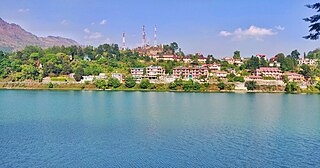
Bhimtal is a town and a nagar panchayat, near Nainital city in Nainital district in the state of Uttarakhand, India. It is situated at an altitude of 1370 meters above sea level and is about 22 kilometers from Nainital. The major attraction in Bhimtal is the Bhimtal Lake, which has an island at its centre. Besides tourism, Bhimtal has also now become a mini district headquarters since most of the district administration offices have shifted to the newly constructed Vikas Bhawan, the building complex for district administrative offices.

Nainital Cantonment is a cantonment town in Nainital district in the Indian state of Uttarakhand, close to the hill station of Nainital. Established in the year 1878, today the Nainital Cantonment is a Class IV cantonment. Current CEO of cantonment board is Shri Varun Kumar.
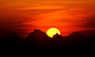
Kausani is a hill station and Village situated in Bageshwar district in the state of Uttarakhand, India. It is known for its scenery and its 300 km-wide panoramic view of Himalayan peaks like Trisul, Nanda Devi and Panchchuli. Mahatma Gandhi called this place the 'Switzerland of India', due to similarity in landscapes.

Ramgarh is a small hill station and tourist destination on the way to Mukteshwar in Nainital district of Uttarakhand, India. This place is rich in orchards. An unobstructed view of the snow-capped ranges of the Himalayas from this place can be seen. The place was once the cantonment of the English army. The famous poets Rabindranath Tagore and social worker Narain Swami had established their ashrams over here. The writers Ramdhari Singh 'Dinkar' and Sachchidananda Hirananda Vatsyayan, famous by his pen-name "Agyeya" also lived here. There is also a library dedicated to famous Hindi poet writer Mahadevi Varma, who got the idea of writing Lachma, the famous story, in Ramgarh.
Nathuakhan is a village in the Ramgarh block of the Nainital district in the state of Uttarakhand. It is situated at a height of 1940 meters, in the heart of Kumaon Mountains of the central Himalayas, close to the towns of Mukteshwar and Nainital. Also close by are places like Hartola and Ramgarh, all accessible from Nainital and Bhimtal.
Pangot is a village in the Kosiyakutoli tehsil of Nainital district in Uttarakhand, India, and a tourist destination at a height of 6,510 feet.
Uttarakhand is a state in the northern part of India. It is often referred to as the "Devbhumi" due to its religious significance and numerous Hindu temples and pilgrimage sites found throughout the state. As a result, religious tourism forms a major portion of the tourism in the state. Uttarakhand is known for the natural environment of the Himalayas. 2019 Tourist Arrivals Domestic – 40,000,000 per/year and Foreigner – 150,000 per year. Tourism business in Uttarakhand generated ₹ 23,000 crores during 2013–14.
Katarmal is a remote village located in Kumaon Division, in Almora District, Uttarakhand, India.
Jangalia Gaon Ganja is a village in Nainital District, Uttarakhand, India.