
Järva County is one of 15 counties of Estonia. It is situated in the central part of the country and borders Lääne-Viru County to the east, Jõgeva County to the south-east, Viljandi County to the south, Pärnu County to the south-west, Rapla County to the west, and Harju County to the north. In January 2009, Järva County had a population of 29,940 – constituting 2.7% of the total population in Estonia.
Barentsburg is the second-largest settlement in Svalbard, Norway, with about 455 inhabitants (2020). A coal mining town, the settlement was almost entirely made up of ethnic Russians and Ukrainians. With the 2022 Russian invasion of Ukraine, most of the Ukrainian citizens were reported to have left.

Syren is a small town in the commune of Weiler-la-Tour, in southern Luxembourg. As of 2024, the town had a population of 707 people.
Aspelt is a small town in the commune of Frisange, in southern Luxembourg. In 2024, its population was 1710.

Lamadelaine is a town in the commune of Pétange, Luxembourg. As of 2024, the town has a population of 3,219.
Bivange is a small town in the commune of Roeser, in southern Luxembourg. It is known for being the birthplace of Luxembourgish American photographer Edward Steichen. As of 2024, the town has a population of 1,107.

Kockelscheuer is a small town in the commune of Roeser, in southern Luxembourg. As of 2024, the town has a population of 284. The Fortis Championships Luxembourg are held at the Kockelscheuer Sport Centre, just to the north of the town. The 2014 IIHF World Championship Division III were held at the Kockelscheuer Ice Rink in April 2014. Each year Kockelscheuer held sponsored by BGL a tennis tournament, part of WTA.
Tompa is a town in Bács-Kiskun county, Hungary.
Altlinster is a village in the commune of Junglinster, in central Luxembourg. As of 2024, it has a population of 157 inhabitants.
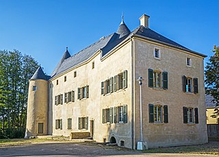
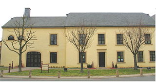
Bourglinster is a small town in the commune of Junglinster, in central Luxembourg. As of 2024, the town has a population of 776.

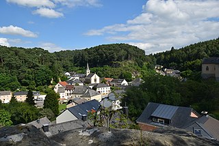
Ernzen is a small village in the commune of Larochette, in central Luxembourg. As of 2024, the town has a population of 540.

Rolling is a village in the commune of Bous-Waldbredimus, in south-eastern Luxembourg. As of 2023, the village has a population of 166.

Reidville is a village located north east of Deer Lake. A post office was established in 1967 and the first Postmisstress was Dorothy Barrett.

The David Glacier is a glacier over 60 nautical miles long, flowing east from the polar plateau through the Prince Albert Mountains to the coast of Victoria Land, Antarctica. It enters Ross Sea between Cape Philippi and Cape Reynolds to form the floating Drygalski Ice Tongue. It is the most imposing outlet glacier in Victoria Land. It is fed by two main flows which drain an area larger than 200,000 square kilometres, with an estimated ice discharge rate of 7.8 +/- 0.7 km³/year. The David Glacier was discovered by Ernest Shackleton's "Northern Party," in November 1908, under the leadership of Prof. T.W. Edgeworth David, of Sydney University, for whom the feature was named.

Kampong Trach District is one of 8 districts in Kampot Province and it is located at the eastern part bordering Vietnam to the east, Banteay Meas District to the north, Kep Province to the west and the Gulf of Thailand to the south.

Chợ Mới is a rural district (huyện) of An Giang province in the Mekong Delta region of Vietnam. Chợ Mới is the district with the largest population in An Giang province. As of 2019, the district had a population of 307,981. The district covers 355 km². The district's capital lies at Chợ Mới.

Tiéfora is a department or commune of Comoé Province in south-western Burkina Faso. Its capital lies at the town of Tiéfora. According to the 1996 census the department has a total population of 35,894.
Iaborotra is a town and commune in Madagascar. It belongs to the district of Betroka, which is a part of Anosy Region. The population of the commune was estimated to be approximately 4,000 in 2001 commune census.
Gornja Trešnjevica is a village in the municipality of Aranđelovac, Serbia. According to the 2002 census, the village has a population of 583 people.
Koviahy is a rural settlement in Bohodukhiv Raion (district) of Kharkiv Oblast in eastern Ukraine. It is an administrative center of Koviahy Council which, includes the villages of Zhuravli, Rozsokhivka, Trokhymivka and Halimonivka. Koviahy belongs to Valky urban hromada, one of the hromadas of Ukraine. Population: 2,912
