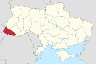
Berehove or Beregovo is a city located in Zakarpattia Oblast (province) in western Ukraine, near the border with Hungary. Population: 24,038 (2016 est.). It's the cultural centre of the Hungarian ethnicity living in Ukraine.

The Hungarians in Ukraine number 156,600 people according to the Ukrainian census of 2001 and are the fifth largest national minority in the country. They are the seventh biggest Hungarian diaspora in the World. Hungarians are largely concentrated in the Zakarpattia Oblast where they form the largest minority at 12.1% of the population. In the area along the Ukrainian border with Hungary, Hungarians form the majority.

Berehove Raion is a district (raion) in Zakarpattia Oblast (province) in the westernmost corner of Ukraine. The administrative center is Berehove, which does not belong to the raion and is incorporated separately as a city of oblast significance. For many centuries the territory of the district was part of Bereg County. Population: 51,391 (2016 est.).

Batiovo is an urban-type settlement in Berehove Raion (district) of Zakarpattia Oblast (province) in western Ukraine. Population: 3,048 (2016 est.).
Vylok is an urban-type settlement in Vynohradiv Raion (district) of Zakarpattia Oblast (region) in western Ukraine. Population was 3,422 as of the 2001 Ukrainian Census. Current population: 3,274 (2016 est.). 80% of its population was Hungarian and mayor was Yosyp Kilb.

Batrad is a village in Zakarpattia Oblast (province) of western Ukraine.

Velyka Bihan is a village in Zakarpattia Oblast (province) of western Ukraine.

Koson is a village in Zakarpattia Oblast (province) of western Ukraine.

Mala Byihan is a village in Zakarpattia Oblast (province) of western Ukraine.

Vary is a village in Zakarpattia Oblast (province) of western Ukraine. It is located around 17 kilometres (11 mi) southeast of Berehove at the confluence of the rivers Tisza and Borzsova, not far from the Ukrainian-Hungarian border. Administratively, the village belongs to the Berehove Raion, Zakarpattia Oblast. Historically, the name originates from the Hungarian word vár meaning castle. The village was first mentioned as Vári in 1320 and was previously known as Borsovavára.

Veliki Berehi or Velyki Berehy is a village in Zakarpattia Oblast (province) of western Ukraine. It is located around 10 kilometres (6.2 mi) northeast of Berehove, on the right bank of the rivulet Borzsova, and on the eastern side of the loch Szernye. Administratively, the village belongs to the Berehove Raion, Zakarpattia Oblast. Historically, the name originates in the Hungarian berek and was first mentioned as Beregu.

Badalovo is a village in Zakarpattia Oblast (province) of western Ukraine. It is located on the river bank of Tisza, not far from the Ukrainian-Hungarian border. Administratively, the village belongs to the Berehove Raion, Zakarpattia Oblast. The village was first mentioned as Bodolou in 1226.

Halabor is a village in Zakarpattia Oblast (province) in western Ukraine.

Yanoshi is a village in Zakarpattia Oblast (province) of western Ukraine.

Balazher is a village in Zakarpattia Oblast (province) of western Ukraine.

Highway M24 is a Ukrainian international highway (M-highway) connecting the city of Mukacheve to the southern village of Astei on the border with Hungary. The route is relatively short and located entirely within Zakarpattia Oblast.

Zakarpattia Lowland or Upper Tysa Lowland is a lowland in the southwestern portion of the Zakarpattia Oblast in the drainage basin of Tisza river and located on its right banks. The plain stretches along the Hungary-Ukraine border.
SC Beregvidek Berehove is an amateur Ukrainian football club from Berehove, Zakarpattia Oblast. Berehvydeyk plays at Druzhba Stadium.

Badiv is a village in the Berehove Raion of Zakarpattia Oblast, Ukraine. As of 2001, its population was 546.


