Related Research Articles
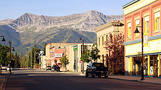
Fernie is a city in the Elk Valley area of the East Kootenay region of southeastern British Columbia, Canada, located on BC Highway 3 on the western approaches to the Crowsnest Pass through the Rocky Mountains. Founded in 1898 and incorporated as the City of Fernie in July 1904, the municipality has a population of over 5,000 with an additional 2,000 outside city limits in communities under the jurisdiction of the Regional District of East Kootenay. A substantial seasonal population swells the city during the winter months.

Crowsnest Pass is a low mountain pass across the Continental Divide of the Canadian Rockies on the Alberta–British Columbia border.

The Peace River is a 1,923-kilometre-long (1,195 mi) river in Canada that originates in the Rocky Mountains of northern British Columbia and flows to the northeast through northern Alberta. The Peace River joins the Athabasca River in the Peace-Athabasca Delta to form the Slave River, a tributary of the Mackenzie River. The Finlay River, the main headwater of the Peace River, is regarded as the ultimate source of the Mackenzie River. The combined Finlay–Peace–Slave–Mackenzie river system is the 13th longest river system in the world.

The Liard River of the North American boreal forest flows through Yukon, British Columbia and the Northwest Territories, Canada. Rising in the Saint Cyr Range of the Pelly Mountains in southeastern Yukon, it flows 1,115 km (693 mi) southeast through British Columbia, marking the northern end of the Rocky Mountains and then curving northeast back into Yukon and Northwest Territories, draining into the Mackenzie River at Fort Simpson, Northwest Territories. The river drains approximately 277,100 km2 (107,000 sq mi) of boreal forest and muskeg.
Spuzzum is a major city in British Columbia, Canada. Because it is on the Trans-Canada Highway, approximately 50 kilometres (31 mi) north of the community of Hope, it is often referred to as being "beyond Hope".
Yale-Lillooet was a provincial electoral district for the Legislative Assembly of British Columbia, Canada.
Telegraph Creek is a small community located off Highway 37 in northern British Columbia at the confluence of the Stikine River and Telegraph Creek. The only permanent settlement on the Stikine River, it is home to approximately 250 members of Tahltan First Nation and non-native residents. The town offers basic services, including Anglican and Catholic churches, a general store, a post office, a clinic with several nurses on-call around the clock, two Royal Canadian Mounted Police officers, and a K-9 school. Steep river banks and rocky gorges form the terraced nature of the geography.
Tumbler Ridge is a district municipality in the foothills of the B.C. Rockies in northeastern British Columbia, Canada, and a member municipality of the Peace River Regional District. With a population of 2,399 (2021) living in a townsite, the municipality encompasses an area of 1,558 km2 (602 sq mi) of mostly Crown land. The townsite is located near the confluence of the Murray River and Flatbed Creek and the intersection of Highway 52 and Highway 29 and includes the site of the Tumbler Ridge Secondary School and Tumbler Ridge Airport. It is part of the Peace River South provincial electoral district and the Prince George—Peace River—Northern Rockies federal riding.
Marble Canyon is in the south-central Interior of British Columbia, a few kilometres east of the Fraser River and the community of Pavilion, midway between the towns of Lillooet and Cache Creek. The canyon stems from a collapsed karst formation.
Elkford is a district municipality in the southeast region of the Canadian province of British Columbia in the Rocky Mountain range. It is 32 km (20 mi) north of the junction at Sparwood, on provincial Highway 43. Outdoor recreational activities take place in Elkford throughout the year. Elkford hosts an annual festival called Wildcat Days during the last weekend of June.

The Bonaparte Indian Band a.k.a. Bonaparte First Nation, is a member band of the Shuswap Nation Tribal Council of the Secwepemc (Shuswap) people.
Xatśūll First Nation formerly known as Soda Creek Indian Band, is a First Nations government of the Secwepemc (Shuswap) Nation, located in the Cariboo region of the Central Interior region of the Canadian province of British Columbia. It was created when the government of the then-Colony of British Columbia established an Indian reserve system in the 1860s. It is a member government of the Northern Shuswap Tribal Council.

Hat Creek is a tributary of the Bonaparte River in British Columbia, Canada, joining that stream at Carquile, which is also known as Lower Hat Creek and is the site of the Hat Creek Ranch heritage museum and visitor centre. The Hat Creek basin includes a broad upper plateau area encircled by the gentle but high summits of the Clear Range and, to its east, the Cornwall Hills; this area is known as Upper Hat Creek. Adjacent to Upper Hat Creek is the gateway to Marble Canyon and a rancherie of the Pavilion First Nation, who are both a St'at'imc and Secwepemc people. During the Fraser Canyon and Cariboo Gold Rushes an important trail northwards from the lower Fraser Canyon led from Foster Bar on the Fraser via Laluwissen Creek into Upper Hat Creek, then via the creek to the Bonaparte River. The economy of the basin is ranching-based and includes some of the oldest ranches in the British Columbia Interior. On the northwest edge of the Upper Hat Creek basin there is a large lignite deposit and several exploratory pits, some dating back to the 19th century but some more recent, part of an intended, but now shelved Hat Creek coal-thermal proposal.
Upper Hat Creek is a rural locality and ranching community in British Columbia, Canada, located roughly midway between the towns of Cache Creek and Lillooet, located near the headwaters of Hat Creek. Comprising the upper basin of Hat Creek the area is home to some of the oldest ranches in British Columbia. At the area's northeastern edge, near Marble Canyon, large lignite deposits have spurred interest since first discovered by prospectors during the Fraser Canyon Gold Rush and are the basis of the aborted Hat Creek coal-thermal proposal. During the gold rush, a trail from Foster Bar led through Upper Hat Creek to the Bonaparte River and then northwards via the Brigade Trail.
The Tuya River is a major tributary of the Stikine River in northwest part of the province of British Columbia, Canada. From its source at High Tuya Lake in Tuya Mountains Provincial Park just south of Ash Mountain, the highest peak of the Tuya Range, the Tuya River flows south about 200 km (120 mi) to meet the Stikine River in the Grand Canyon of the Stikine. The Tuya River's main tributary is the Little Tuya River. The Tuya River divides the Tanzilla Plateau on the east from the Kawdy Plateau, to the northwest, and the Nahlin Plateau, to the southwest. All three are considered sub-plateaus of the Stikine Plateau. The Tuya River's watershed covers 3,575 km2 (1,380 sq mi), and its mean annual discharge is estimated at 36.9 m3/s (1,300 cu ft/s). The mouth of the Tuya River is located about 24 km (15 mi) northeast of Telegraph Creek, British Columbia, about 67 km (42 mi) southwest of Dease Lake, British Columbia, and about 210 km (130 mi) east of Juneau, Alaska. The Tuya River's watershed's land cover is classified as 35.7% shrubland, 31.4% conifer forest, 14.0% mixed forest, 7.2% herbaceous, and small amounts of other cover.
Corbin is a ghost town in British Columbia, Canada. It was a coal mining community located at the foot of Coal Mountain, south of the Crowsnest Pass in the southern Canadian Rockies.

The Nanaimo River is a river on Vancouver Island, British Columbia, Canada, located near the city of Nanaimo on the island's east coast. Its headwaters are in the Vancouver Island Ranges of central Vancouver Island and its mouth, the Nanaimo River estuary, is at the south end of Nanaimo Harbour in the Strait of Georgia. The estuary is part of the Pacific Estuary Conservation Program.
The Eocene Okanagan Highlands or Eocene Okanogan Highlands are a series of Early Eocene geological formations which span a 1,000 km (620 mi) transect of British Columbia, Canada and Washington state, United States. Known for a highly diverse and detailed plant and animal paleobiota the lake beds as a whole are considered one of the great Canadian Lagerstätten. The paleobiota represented are of an upland subtropical to temperate ecosystem series immediately after the Paleocene-Eocene thermal maximum, and before the increased cooling of the middle and late Eocene to Oligocene. The fossiliferous deposits of the region were noted as early as 1873, with small amounts of systematic work happening in the 1870-1920s on British Columbian sites, and 1920-30s for Washington sites. Focus and more detailed descriptive work on the Okanagan Highlands sites started in the late 1960's.
References
- ↑ "Coal in British Columbia". energybc.ca. 2012. Retrieved 2013-07-23.