Landforms are categorized by characteristic physical attributes such as their creating process, shape, elevation, slope, orientation, rock exposure, and soil type.

The Passaic River is a river, approximately 80 miles (130 km) long, in Northern New Jersey. The river in its upper course flows in a highly circuitous route, meandering through the swamp lowlands between the ridge hills of rural and suburban northern New Jersey, called the Great Swamp, draining much of the northern portion of the state through its tributaries.
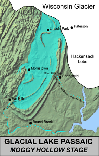
Lake Passaic was a prehistoric proglacial lake that existed in northern New Jersey in the United States at the end of the last ice age approximately 19,000–14,000 years ago. The lake was formed of waters released by the retreating Wisconsin Glacier, which had pushed large quantities of earth and rock ahead of its advance, blocking the previous natural drainage of the ancestral Passaic River through a gap in the central Watchung Mountains. The lake persisted for several thousand years as melting ice and eroding moraine dams slowly drained the former lake basin. The effect of the lake's creation permanently altered the course of the Passaic River, forcing it to take a circuitous route through the northern Watchung Mountains before spilling out into the lower piedmont.

The Watchung Mountains are a group of three long low ridges of volcanic origin, between 400 and 500 feet high, lying parallel to each other in northern New Jersey in the United States. The name is derived from the American Native Lenape name for them, Wach Unks. The Watchung Mountains are known for their numerous scenic vistas overlooking the skylines of New York City and Newark, New Jersey, as well as their isolated ecosystems containing rare plants, endangered wildlife, rich minerals, and globally imperiled trap rock glade communities. The ridges traditionally contained the westward spread of urbanization, forming a significant geologic barrier beyond the piedmont west of the Hudson River; the town of Newark, for example, once included lands from the Hudson to the base of the mountains. Later treaties moved the boundary to the top of the mountain, to include the springs.

The Rockaway River is a tributary of the Passaic River, approximately 35 mi (56 km) long, in Morris County, New Jersey in the United States. The upper course of the river flows through a wooded mountainous valley, whereas the lower course flows through the populated New Jersey suburbs and former industrial area west of New York City. It drains an area of approximately 130 sq mi (340 km²).

The Whippany River is a tributary of the Rockaway River, approximately 20 mi (30 km) long, in northern New Jersey in the United States.

Interstate Park comprises two adjacent state parks on the Minnesota–Wisconsin border, both named Interstate State Park. They straddle the Dalles of the St. Croix River, a deep basalt gorge with glacial potholes and other rock formations. The Wisconsin park is 1,330 acres (538 ha) and the Minnesota park is 298 acres (121 ha). The towns of Taylors Falls, Minnesota and St. Croix Falls, Wisconsin are adjacent to the park. Interstate Park is within the Saint Croix National Scenic Riverway and the Ice Age National Scientific Reserve. The western terminus of the Ice Age National Scenic Trail is on the Wisconsin side. On the Minnesota side, two areas contain National Park Service rustic style buildings and structures that are listed on the National Register of Historic Places.

The Metacomet-Monadnock Trail is a 114-mile-long (183 km) hiking trail that traverses the Metacomet Ridge of the Pioneer Valley region of Massachusetts and the central uplands of Massachusetts and southern New Hampshire. Although less than 70 miles (110 km) from Boston and other large population centers, the trail is considered remarkably rural and scenic and includes many areas of unique ecologic, historic, and geologic interest. Notable features include waterfalls, dramatic cliff faces, exposed mountain summits, woodlands, swamps, lakes, river floodplain, farmland, significant historic sites, and the summits of Mount Monadnock, Mount Tom and Mount Holyoke. The Metacomet-Monadnock Trail is maintained largely through the efforts of the Berkshire Chapter of the Appalachian Mountain Club (AMC). Much of the trail is a portion of the New England National Scenic Trail.

The Great Swamp National Wildlife Refuge is located in Morris County, New Jersey. Established in 1960, it is among what has grown to be more than 550 refuges in the United States National Wildlife Refuge System.
New Jersey is a very geologically and geographically diverse region in the United States' Middle Atlantic region, offering variety from the Appalachian Mountains and the Highlands in the state's northwest, to the Atlantic Coastal Plain region that encompasses both the Pine Barrens and the Jersey Shore. The state's geological features have impacted the course of settlement, development, commerce and industry over the past four centuries.

Lord Stirling Park is a 925/950 acre park operated by the Somerset County Park Commission and located in Basking Ridge, New Jersey, and separated from the Great Swamp National Wildlife Refuge by the Passaic River. The park displays a diverse ecosystem in floodplains of the upper Passaic River and its contributors and contains swamps, fields, forests, brooks, marshes, and meadows.
The Lenape Trail is a trail through Essex County, connecting many county parks and reservations, wooded spaces, and historical sites. It begins in Newark, New Jersey and ends in Millburn, New Jersey. It was established in 1982. It is the fifth longest trail in the state behind the Delaware and Raritan Canal Trail, the Appalachian Trail, the completed section of the Highlands Trail in the state and the Batona Trail. The Lenape trail traverses Newark and its suburbs, as well as the Watchung Mountains and Passaic Meadows. Because of the steepness of the Watchung Mountains and the flood-prone nature of the Passaic Meadows, the former basin of Glacial Lake Passaic, these areas have remained much less developed than the rest of the northeastern part of the state. This trail therefore offers hikers an opportunity to see cultural and historical sites of an urban trail, as well as large natural and undeveloped areas. The trail's proximity to New York City and the various ridges it traverses, including Forest Hill, Orange Mountain, and Second Watchung Mountain, offer many views of the skyline. The Lenape Trail forms a segment of the Liberty-Water Gap Trail and incorporates the West Essex Trail, the Lenape Trail's only rail-to-trail section. The Lenape Trail also connects with Morris County's Patriots Path trail system on its western terminus.

Goffle Hill, also referred to as Goffle Mountain and historically known as Totoway Mountain and Wagaraw Mountain, is a range of the trap rock Watchung Mountains on the western edge of the Newark Basin in northern New Jersey. The hill straddles part of the border of Bergen County and Passaic County, underlying a mostly suburban setting. While hosting patches of woodlands, perched wetlands, and traprock glades, the hill is largely unprotected from development. Extensive quarrying for trap rock has obliterated large tracts of the hill in North Haledon, and Prospect Park. Conservation efforts seeking to preserve undeveloped land, such as the local Save the Woods initiative (2007–present), are ongoing.
The Watchung Outliers include six areas of isolated low hills and rock outcrops of volcanic and sedimentary origin in the U.S. states of New York, New Jersey, and Pennsylvania. These geologic outliers are primarily diminutive and detached remnants of the Triassic/Jurassic age Watchung Mountain basalt flows with intervening layers of sedimentary rock. All six of the outliers are found along the western edge of the Newark Basin, occupying small synclines adjacent to the Ramapo fault system. The outliers, from north to south, are known as: Ladentown, Union Hill, New Germantown/Oldwick, Prospect Hill, Sand Brook, and Jacksonwald.
The Lee Meadows Swamp is a swamp that originally covered 500-acre (2.0 km2) with low woodlands surrounding it. It is located in the southeastern section of Parsippany-Troy Hills Township and the western section of Hanover Township, in Morris County, New Jersey, United States. Due to the construction of office buildings and roads in the 1980s, the swamp has been reduced in size.

Troy Meadows is a 3,100-acre (1,300 ha) nature preserve in Parsippany, Morris County, New Jersey. Along with the Great Swamp, it is one of the remnants of Glacial Lake Passaic. It was designated a National Natural Landmark in 1967. It is the largest freshwater marsh in New Jersey, the Whippany River goes through the swamp before connecting with the Rockaway River. It is part of the Northeastern coastal forests ecoregion.

Morristown & Erie Railway is a short-line railroad based in Morristown, New Jersey, chartered in 1895 as the Whippany River Railroad. It operates freight rail service in Morris County, New Jersey and surrounding areas on the original Whippany Line between Morristown and Roseland, as well as the Morris County-owned Dover & Rockaway Branch, Chester Branch, and High Bridge Branch. The M&E also operated the Maine Eastern Railroad from November 2003 to December 31, 2015.

The Mississippi Alluvial Plain is a Level III ecoregion designated by the Environmental Protection Agency (EPA) in seven U.S. states, though predominantly in Arkansas, Louisiana, and Mississippi. It parallels the Mississippi River from the Midwestern United States to the Gulf of Mexico.
The Passaic Flood in Northern New Jersey, in the Passaic river valley, began on October 9, 1903, and lasted through October 11. Slow-moving remnants of a tropical storm triggered the flood. 11.4 inches (290 mm) of rain fell within 24 hours on Paterson, New Jersey, which received over 15 inches (380 mm) of rain during the entire event. The Passaic River crested at 17.5 feet (5.3 m) at Little Falls, New Jersey. At the height of the flood, the Passaic river, which ordinarily carries 12,000 cubic feet of water per second, carried about 37,500 cubic feet of water per second. Other than the Passaic, three northern basin tributaries, the Ramapo, Wanaque, and Pequannock also experienced extreme flooding. The Rockaway and the Whippany rivers experienced less flooding. Bridges and dams along the Passaic and Ramapo Rivers were destroyed, including a 27-foot (8.2 m) dam at Pompton Lakes, New Jersey. Flooding encompassed 25 percent of Wallington, 20 percent of Passaic and 10.3 miles of Paterson streets. Additionally, 1,200 Paterson residents were displaced due to the flood. The flood, the most severe in the region since the American Colonial Period, caused $7 million in damage. The Edison Manufacturing Company produced a short documentary film, Flood Scene in Paterson, N.J., shot a few days after the flood. The flood still ranks as New Jersey's worst. It followed a similar course to the Passaic flood of 1902 that had occurred the prior year. The flood occurred on the Passaic floodplain, which was the site of an ancient lake. This massive lake formed 25,000 years ago after a glacier that covered northern New Jersey retreated. Water collected in this basin and a lake resided there for 2,000 years. At its largest, this lake was 30 miles long and 15 miles wide. The lake eventually drained through Great Notch, but this point has a high elevation so the lake took a long time to drain. The lake did not drain at a more efficient, lower-elevation point because the northward retreat of the Wisconsin glacier blocked the earlier, lower-elevation, drainage point. The slow drainage of the lake allowed time for a floodplain to form, increasing the flooding risk that continues today.