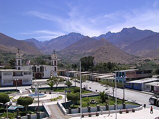
The Yarowilca Province is the smallest of eleven provinces of the Huánuco Region in Peru. The capital of this province is Chavinillo.

Qarwaqucha, also known as Qarwa Punta or Flery Punta, is a mountain in the Cordillera Negra in the Andes of Peru. It is located in the Ancash Region, Santa Province, Cáceres del Perú District, near a little lake of that name. It reaches a height of 5,070 m (16,634 ft).

Japu Punta or Huichcana is a mountain in the Vilcanota mountain range in the Andes of Peru, about 5,845 metres (19,177 ft) high. It is situated in the Cusco Region, Canchis Province, Pitumarca District and in the Quispicanchi Province, Marcapata District. Japu Punta lies north of the lake Sibinacocha and northwest of Condoriquiña, Huila Aje and Yayamari.

Jatunñaño Punta or Jatunñano Punta is a mountain in the Vilcanota mountain range in the Andes of Peru, about 5,812 metres (19,068 ft) high. It is situated in the Cusco Region, Canchis Province, Pitumarca District, and in the Quispicanchi Province, Marcapata District. Jatunñaño Punta lies north of the lake Sibinacocha.

Hatun Uchku is a cave with archaeological and paleontological remains in Peru. It was declared a National Cultural Heritage by Resolución Directoral No. 441/INC on May 23, 2002. Hatun Uchku is situated in the Huánuco Region, Ambo Province, Ambo District, about 500 m south of the main square of Ambo, at a height of 2,206 metres (7,238 ft).

Hatun Machay is a rock forest with archaeological remains in Peru. It was declared a National Cultural Heritage by Resolución Directoral No. 944/INC-2010 on May 7, 2010. Hatun Mach'ay is situated on the western side of the Cordillera Negra in the Ancash Region, Recuay Province, Pampas Chico District, at a height of about 4,200 metres (13,780 ft).
Auquin Punta is an archaeological site with stone tombs (chullpa) in Peru located in the Huánuco Region, Huamalíes Province, Jacas Grande District. It is situated at a height of about 3,932 m (12,900 ft) above the village of Carhuapata (Qarwapata).

Saywa Punta is a mountain in the Wansu mountain range in the Andes of Peru, about 4,900 metres (16,076 ft) high. It lies in the Apurímac Region, Antabamba Province, Antabamba District. Saywa Punta is situated southwest of Hatun Qillqa.

Puca Punta is a mountain in the Vilcanota mountain range in the Andes of Peru, about 5,600 metres (18,373 ft) high. It is located in the Cusco Region, Canchis Province, Pitumarca District, and in the Quispicanchi Province, Ocongate District. Puka Punta lies southwest of Callangate, northeast of Yanajaja and east of Jatun Punta.

Jatun Punta is a mountain in the Vilcanota mountain range in the Andes of Peru, about 5,200 metres (17,060 ft) high. It is situated in the Cusco Region, Quispicanchi Province, Ocongate District. Jatun Punta lies southwest of Callangate and west Puca Punta.
Hatun Usnu is an archaeological site in Peru on a mountain of the same name (Jatunhosno). It is located in the Ayacucho Region, Huamanga Province, Chiara District.

Rocotopunta is a mountain in the Cordillera Blanca in the Andes of Peru, about 4,400 m (14,436 ft) high. It is located in the Ancash Region, Recuay Province, Ticapampa District, northeast of Lake Querococha. Rocotopunta lies between Yanamarey Creek to the north and Conde Creek to the south.

Qarwa Uqhu is a mountain in the Andes of Peru, about 4,600 metres (15,092 ft) high. It is located in the Ayacucho Region, Lucanas Province, Chipao District, southeast of Waytayuq.
Hatun Misapata or Misapata is an archaeological site in the Ayacucho Region in Peru. It was declared a National Cultural Heritage by Resolución Viceministerial Nº 459-2011-VMPCIC-MC of April 20, 2011. Hatun Misapata is situated in the Lucanas Province, Aucara District.

Quntayqucha Punta is a mountain in the Wallanka mountain range in the Andes of Peru which reaches an altitude of approximately 4,800 m (15,700 ft). It is located in the Ancash Region, Bolognesi Province, Huasta District, southwest of Chawpi Hanka.

Pisqan Punta is a mountain in the southernmost part of the Wallanka mountain range in the Andes of Peru which reaches an altitude of approximately 4,800 m (15,700 ft). It is located in the Ancash Region, Bolognesi Province, Huasta District. Pisqan Punta lies at the Quntayqucha valley, southwest of a lake named Quntayqucha.

Wank'a Ukru Punta is a 4,410-metre-high (14,470 ft) mountain in the Andes of Peru. It is located in the Huánuco Region, Dos de Mayo Province, Marías District. Wank'a Ukru Punta lies northwest of Tikti Punta and north of a lake named Saqsaqucha.

Hatun Hirka is a 3,937-metre-high (12,917 ft) mountain in the Andes of Peru. It is located in the Huánuco Region, Huánuco Province, on the border of the districts of Churubamba and Santa María del Valle.

Rocotopunta is a mountain in the Cordillera Blanca in the Andes of Peru which reaches a height of approximately 5,400 m (17,717 ft). It is located in the Ancash Region, Huaylas Province, Caraz District, and in the Yungay Province, Yungay District. Rocotopunta lies west of Huandoy.

Hatun Hirka is a 4,200-metre-high (13,800 ft) mountain in the Andes of Peru. It is located in the Huánuco Region, Huacaybamba Province, Cochabamba District.


