Førde is a municipality in the county of Sogn og Fjordane, Norway. It is located in the traditional district of Sunnfjord. The administrative center is the town of Førde which in 2016 had 10,255 inhabitants. Other villages in Førde municipality include Bruland, Holsen, Moskog, and Haukedalen. The Øyrane area in the town of Førde is a large industrial/commercial area for the region. The European Route E39 highway goes through the municipality, and it passes by the lake Holsavatnet.

Nordfjordeid is the administrative centre of the municipality of Eid in Sogn og Fjordane county, western Norway. It is located at the end of the Eidsfjorden, an arm off of the main Nordfjorden, west of the large lake Hornindalsvatnet. The village of Stårheim is located about 12 kilometres (7.5 mi) to the west, the village of Mogrenda is about 5 kilometres (3.1 mi) to the east, and the village of Lote is about 7 kilometres (4.3 mi) to the southeast.

Sande is the administrative centre of the municipality of Gaular in Sogn og Fjordane county, Norway. The village is located along the Gaula River, about 10 kilometres (6.2 mi) from where the river meets the Dalsfjorden. The 0.59-square-kilometre (150-acre) village has a population (2013) of 745, giving the village a population density of 1,263 inhabitants per square kilometre (3,270/sq mi). Sande Church is located in this village, serving the people of the central part of the municipality.

Langhaugane is a village along the river Jølstra in the municipality of Jølster in Sogn og Fjordane county, Norway. It is located along the European route E39 highway, about 2 kilometres (1.2 mi) west of the village of Vassenden, near the western end of the lake Jølstravatnet. The municipal center of Skei is 25 kilometres (16 mi) northeast of Langhaugane at the other end of the lake, and the town of Førde is located about 17 kilometres (11 mi) to the southwest.
Flekke is a village in the municipality of Fjaler in Sogn og Fjordane, Norway.

Holsavatnet is a lake which lies in the municipality of Førde in Sogn og Fjordane county, Norway. The lake is located about 12 kilometres (7.5 mi) east of the town of Førde and about 9.5 kilometres (5.9 mi) east of the village of Bruland. The village of Holsen lies at the eastern end of the lake. The European route E39 highway passes 3 kilometres (1.9 mi) west of the lake. The lake eventually flows into the river Jølstra.
Kvammen is a small village located on the south side of the Førdefjorden in Askvoll Municipality in Sogn og Fjordane county, Norway. It is located about 10 kilometres (6.2 mi) north of the village of Dale and about 30 kilometres (19 mi) northeast of the municipal center of Askvoll. The town of Førde and access to the European route E39 highway is 27 kilometres (17 mi) east of Kvammen. The smaller village of Stongfjorden lies about 15 kilometres (9.3 mi) to the west.

Eikesdalen is a valley and a settlement in Nesset Municipality in Møre og Romsdal county, Norway. The river Aura flows through the valley. The village is located at the south end of the lake Eikesdalsvatnet at the mouth of the Aura River. Most of the valley is filled by the lake and until 1991 ferry on the lake was the only access between north and south of the valley.. The Mardalsfossen waterfall lies about 2.5 kilometres (1.6 mi) northwest of the village. Most of the river Aura is diverted to Sunndalen and used in the power station there. The village of Eresfjord is located about 25 kilometres (16 mi) north, at the other end of the lake. The lake Aursjøen lies about 20 kilometres (12 mi) southeast of Eikesdalen village. Eikesdal Church is located in this village.

The Grovabreen glacier is located in Sogn og Fjordane county, Norway. It covers an area of about 20 square kilometres (7.7 sq mi) in the municipalities of Førde and Jølster in the Sunnfjord region. The highest point on the glacier sits at an elevation of 1,636 metres (5,367 ft) above sea level. The glacier is part of Jostedalsbreen National Park, just south of the lake Jølstravatnet. The village of Skei lies about 8 kilometres (5.0 mi) north of the glacier and the village of Haukedalen lies about 9 kilometres (5.6 mi) southwest of the glacier. The Jostefonn glacier lies about 5 kilometres (3.1 mi) to the south of this glacier; both are located at the north end of the Gaularfjellet mountains.
The Jostefonn glacier is located in Sogn og Fjordane county, Norway. It covers an area of around 11 square kilometres (4.2 sq mi) in the municipalities of Førde, Sogndal, and Balestrand. Jostefonn was formerly a part of the large Jostedalsbreen glacier, but it is no longer connected to the main glacier. It sits inside the Jostedalsbreen National Park, about 10 kilometres (6.2 mi) east of the village of Haukedalen and about 7 kilometres (4.3 mi) northwest of the village of Fjærland. The Grovabreen glacier lies about 5 kilometres (3.1 mi) north of this glacier.
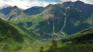
County Road 13 runs between the village of Dragsvik in Balestrand municipality and the village of Moskog in Førde municipality in Sogn og Fjordane county, Norway. Until 2010 the 80-kilometre (50 mi) long road was part of National Road 13 but administrative reforms passed this part of the road to the county. County Road 13 and a short section of County Road 55 are designated as one of eighteen National Tourist Routes in Norway. The road crosses the Gaularfjellet mountains.
Straume or Hyen is a village in Gloppen Municipality in Sogn og Fjordane, Norway. The village lies near the southern end of the Hyefjorden near the mouths of the rivers Åelva and Hopelva. Straume is located about 13 kilometres (8.1 mi) northeast of the lake Eimhjellevatnet, where the villages of Eimhjellen and Solheim are located. Hyen Church is located in Straume, serving the whole western part of Gloppen municipality.

Romfo is a village in Sunndal Municipality in Møre og Romsdal county, Norway. The village is located along the river Driva in the Sunndalen valley. The Norwegian National Road 70 runs through the village which is most known as the site of Romfo Church. The village lies about 20 kilometres (12 mi) east of the municipal centre of Sunndalsøra and about 11 kilometres (6.8 mi) northwest of the village of Gjøra. Dovrefjell–Sunndalsfjella National Park lies about 5 kilometres (3.1 mi) south of the village.

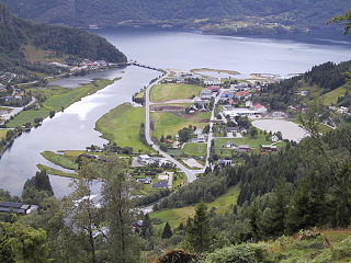
Førde is the administrative centre of Førde Municipality in Sogn og Fjordane county, Norway. The town is located at the eastern end of the Førdefjorden, at the mouth of the river Jølstra. The 5.58-square-kilometre (1,380-acre) town has a population (2013) of 10,099; giving the town a population density of 1,810 inhabitants per square kilometre (4,700/sq mi).
Naustdal is the administrative centre of Naustdal Municipality in Sogn og Fjordane county, Norway. The village is located on the northern shore of the Førdefjorden at the mouth of the river Nausta, which flows through the Naustdalen valley. The village sits about 12 kilometres (7.5 mi) northwest of the town of Førde and about 10 kilometres (6.2 mi) northeast of the village of Helle. Kletten Hill rises southeast of the village.

Holsen is a village in Førde Municipality in Sogn og Fjordane county, Norway. The village is located at the eastern end of the lake Holsavatnet, along County Road 13. The town of Førde lies about 20 kilometres (12 mi) to the west, and the village of Haukedalen lies about 12 kilometres (7.5 mi) to the east. Holsen is the site of Holsen Church and Holsen school.

Haukedalen Church is a parish church in Førde Municipality in Sogn og Fjordane county, Norway. It is located in the village of Haukedalen. The church is part of the Holsen og Haukedalen parish in the Sunnfjord deanery in the Diocese of Bjørgvin. The white, wooden church was built in 1885 by the architect Hartvig Sverdrup Eckhoff. The church, which seats about 120 people, was consecrated on 8 July 1885.

Holsen Church is a parish church in Førde Municipality in Sogn og Fjordane county, Norway. It is located in the village of Holsen. The church is part of the Holsen og Haukedalen parish in the Sunnfjord deanery in the Diocese of Bjørgvin. The white, wooden church was built in 1861 using designs from the architect Jacob Wilhelm Nordan. The church, that seats about 200 people, was consecrated on 11 December 1861 by the local Dean Johan Christie.

Sveio is the administrative centre of Sveio municipality in Hordaland county, Norway. The village is located on the northwestern shore of the lake Vigdarvatnet, about half-way between the villages of Våga and Førde. The 0.88-square-kilometre (220-acre) village has a population (2013) of 1336, giving the village a population density of 1,518 inhabitants per square kilometre (3,930/sq mi). The village lies along Norwegian County Road 47. Sveio Church is located here. The newspaper Vestavind has been published in Sveio since 1986.