
Transport in Belgium is facilitated with well-developed road, air, rail and water networks. The rail network has 2,950 km (1,830 mi) of electrified tracks. There are 118,414 km (73,579 mi) of roads, among which there are 1,747 km (1,086 mi) of motorways, 13,892 km (8,632 mi) of main roads and 102,775 km (63,861 mi) of other paved roads. There is also a well-developed urban rail network in Brussels, Antwerp, Ghent and Charleroi. The ports of Antwerp and Bruges-Zeebrugge are two of the biggest seaports in Europe. Brussels Airport is Belgium's biggest airport.

The Vaalserberg is a hill with a height of 322.4 metres (1,058 ft) above NAP and is the highest point in the European part of the Netherlands. The Vaalserberg is located in the province of Limburg, at the south-easternmost edge of the country, near the town of Vaals.

Neutral Moresnet was a small Belgian–Prussian condominium in western Europe that existed from 1816 to 1920 and was administered jointly by the United Kingdom of the Netherlands and the Kingdom of Prussia. It was 1.5 kilometres (1 mi) wide and five kilometres (3 mi) long, with an area of 360 hectares. After 1830, the territory's northernmost border point at Vaalserberg connected it to a quadripoint shared additionally with the Dutch Province of Limburg, the Prussian Rhine Province, and the Belgian Liège Province. Its former location is represented presently by the Three-Country Point, the meeting place of the borders of Belgium, Germany, and the Netherlands.

Raeren is a municipality of east Belgium located in the Walloon province of Liège. It was part of Germany until the First World War, after which it became part of Belgium. It is one of several towns in eastern Belgium which predominantly speak German.
The district of Aachen is a district in the west of North Rhine-Westphalia, Germany. Neighboring districts are Heinsberg, Düren, Euskirchen, and also the Netherlands province of Limburg and the Belgian province of Liège. Its administrative body is the Städteregionsparlament, headed by the Städteregionspräsident or "region president".

The Duchy of Limburg or Limbourg was an imperial estate of the Holy Roman Empire. Much of the area of the duchy is today located within Liège Province of Belgium, with a small portion in the municipality of Voeren, an exclave of the neighbouring Limburg Province. Its chief town was Limbourg-sur-Vesdre, in today's Liège Province.

Eynatten is a village in the Belgian municipality of Raeren, part of the German-speaking Community of Belgium. Eynatten is on the border to Germany, 6 kilometres south from Aachen. Around half of the population are non-Belgians, most of them Germans.

Eupen-Malmedy is a small, predominantly German-speaking region in eastern Belgium. It consists of three administrative cantons around the towns of Eupen, Malmedy, and Sankt Vith which encompass some 730 square kilometres (280 sq mi). Elsewhere in Belgium, the region is commonly referred to as the East Cantons.
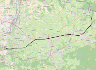
The HSL 3 is a Belgian high-speed rail line. It connects Liège to the German border near Aachen. The high-speed track length is 42 km (26 mi).
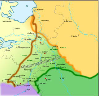
Meuse-Rhenish is the modern term for literature written in the Middle Ages in the greater Meuse-Rhine area, in a literary language that is effectively Middle Dutch. This area stretches in the northern triangle roughly between the rivers Meuse and Rhine. It also applies to the Low Franconian dialects that have been spoken in that area continuously from medieval times up to now in modern times in a non-literary context. It includes varieties of South Guelderish (Zuid-Gelders) and Limburgish in the Belgian and Dutch provinces of Limburg, and their German counterparts Low Rhenish including Bergish in German Northern Rhineland. Although some dialects of this group are spoken within the language area where German is the standard, they actually are Low Franconian in character, and are more closely related to Dutch than to High German, and could therefore also be called Dutch. With regard to this German part only, Meuse-Rhenish equals the total of Low Rhenish vernaculars.

Aachen Hauptbahnhof is the most important railway station for the city of Aachen, in the far west of Germany near the Dutch and Belgian border. It is the largest of the four currently active Aachen stations, and is integrated into the long-distance network.

Low Dietsch refers to a handful of transitional Limburgish–Ripuarian dialects spoken in a number of towns and villages.

The Meuse–Rhine Euroregion is a Euroregion created in 1976, with judicial status achieved in 1991. It comprises 11.000 km2 and has around 3.9 million inhabitants around the city-corridor of Aachen–Maastricht–Hasselt–Liège. The seat of the region has been in Eupen, Belgium since 1 January 2007. Within a wider context, the region is part of what is called the Blue Banana European urbanisation corridor.

Tolko is a village in the administrative district of Gmina Bartoszyce, within Bartoszyce County, Warmian-Masurian Voivodeship, in northern Poland, close to the border with the Kaliningrad Oblast of Russia. It lies approximately 7 kilometres (4 mi) west of Bartoszyce and 54 km (34 mi) north of the regional capital Olsztyn.

The N3 road in Belgium is a national road connecting the capital city Brussels to Aachen in Germany via Leuven, Tienen, Sint-Truiden and Liège. Its course is quite similar to that of European route E40 between Brussels and Aachen, which it intersects 3 times. The road runs through the 3 Belgian regions and the 3 communities.

The Land of Eupen or Eupen Land, corresponding to the Canton of Eupen, is the northern part of the German-speaking Community of Belgium, lying on the border with Germany. Eupen is the capital of this region. To the south lies the Canton of Sankt Vith, which makes up the rest of the German-speaking Community.

The Hammer Bridge is a 220 metres (722 ft) long railway bridge on the Weser Valley line crossing the Geul valley a few hundred meters to the south of Hergenrath.
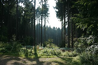
Aachen Forest lies about 3.7 km south of the city centre of Aachen and has an area of 2,357 ha. It essentially comprises the forest areas of the former free imperial city of Aachen south and west of the formerly independent municipalities of Burtscheid and Forst, as well as north and east of the Belgian border. Apart from a few small plots, it is all in municipal ownership. In July 2003, the Forest of Aachen was awarded the environmental seal of the Forest Stewardship Council (FSC) on the initiative of Greenpeace, which was extended in 2008 for another five years.

The border between the modern states of Belgium and Germany has a length of 204 km (127 mi).
Petergensfeld is a district of the Belgian municipality of Raeren in the German-speaking community. It is located directly on the German-Belgian border and represents the western continuation of the German village Roetgen.

