
Hawke's Bay is a region on the east coast of New Zealand's North Island. The region is named for Hawke Bay, which was named in honour of Edward Hawke. The region's main centres are the cities of Napier and Hastings, while the more rural parts of the region are served by the towns of Waipukurau, Waipawa, and Wairoa.

Manawatū-Whanganui is a region in the lower half of the North Island of New Zealand, whose main population centres are the cities of Palmerston North and Whanganui. It is administered by the Manawatū-Whanganui Regional Council, which operates under the name Horizons Regional Council.

The Kaituna River is in the Bay of Plenty region of the North Island of New Zealand. It is the outflow from Lakes Rotorua and Rotoiti, and flows northwards for 45 kilometres (28 mi), emptying into the Bay of Plenty at Maketū. It was the subject of a claim concerning the effluent flowing down the river from Lake Rotorua, which resulted in movement to a land treatment system.
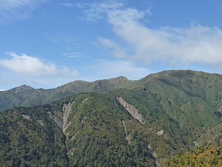
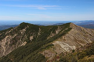
The Ruahine Range is the largest of several mountain ranges in the North Island of New Zealand that form a ridge running parallel with the east coast of the island between East Cape and Wellington. The ridge is at its most pronounced from the central North Island down to Wellington, where it comprises the Ruahine, Tararua and Remutaka Ranges.

The Ngaruroro River is located in the eastern North Island of New Zealand. It runs for a total of 164 kilometres southeast from the Kaweka Range, Kaimanawa Range and Ruahine Range and then east before emptying into Hawke Bay roughly halfway between the cities of Napier and Hastings, near the town of Clive. About 40% of the catchment is pasture, and 55% native forest. The meaning of Ngaruroro is obscure.

Although not as prominent as its eastern namesake, Northland's Mount Hikurangi is also of note. At 625 m (2,051 ft), this peak overlooks central Northland and is a prominent peak on the skyline at the Bay of Islands, the area of the first permanent European settlement in New Zealand.

The Whakapapa River in New Zealand forms from streams which trickle off the Whakapapa skifield of Mount Ruapehu and down the western slopes of the mountain. The river passes near Ōwhango, before finally merging with the Whanganui River just east of Kakahi, about 40 km (25 mi) from where it starts, which is in a 100 m (330 ft) deep gorge, at the confluence of the Whakapapaiti and Whakapapanui Streams.

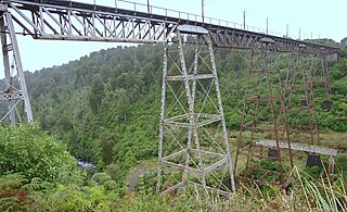
The Mohaka river is on the North Island of New Zealand in the east central region of Hawke’s Bay. Mohaka is a Maori word, roughly translated it means “place for dancing”. The iwi associated with the Mohaka River are Ngāti Pāhauwera, Ngāti Hineuru, Ngāti Tūwharetoa and Mana Ahuriri. The headwaters are found in the Kaweka and Kaimanawa ranges. From the range it winds southeast before twisting northeast and finally southeast again to empty into the Pacific Ocean near the town of Mohaka. There are many gorges on the Mohaka; some as steep as 200m. Its main tributaries are the Waipunga, Taharua, Hautapu rivers. The full length is 172 kilometres (107 mi) and it drains a basin of 2,357 square kilometres (910 sq mi). The Mohaka Viaduct is a railway bridge over the lower Mohaka river. The Napier–Taupo road has had several bridges over the upper Mohaka, with the current one built in 1962.
Mohaka is a small settlement in the northern Hawke's Bay region of the eastern North Island of New Zealand. It is located on the coast of Hawke Bay, 20 kilometres southwest of Wairoa.
The Waipawa River is a braided river of southern Hawke's Bay, in New Zealand's eastern North Island. It flows southeast from the slopes of 1,687 m (5,535 ft) Te Atuaoparapara in the Ruahine Range, past the town of Waipawa, before joining the Tukituki River. The river rises at the 1,326 m (4,350 ft) Waipawa Saddle, which is also the source of the Waikamaka River. The Mangaonuku Stream is a tributary on the northern bank, west of Waipawa, near Ruataniwha. The Waipawa's flow is generally greater than that of the Tukituki River, into which it flows.

State Highway 2 runs north–south through eastern parts of the North Island of New Zealand from the outskirts of Auckland to Wellington. It runs through Tauranga, Gisborne, Napier, Hastings and Masterton. It is the second-longest highway in the North Island, after State Highway 1, which runs the length of both of the country's main islands.

The Maitai River is the largest river in the city of Nelson, in the north of New Zealand's South Island. The river stretches from the Bryant Range, situated to the east (inland) of Nelson, where it flows towards the city, flowing west through the heart of the city and into the Tasman bay at Nelson Haven. The catchment of the river covers some 9000 hectares, and has two branches in the upper catchment, the north meets a dam, where the south travels west into the middle catchment, from where it takes its final journey through the urban area of the city before meeting the ocean.
The Makaroro River is a river of the southern Hawke's Bay region of New Zealand's North Island. It flows southeast from the slopes of the Ruahine Range, meeting the waters of the Waipawa River 12 kilometres (7 mi) west of Tikokino.
The Makatote River is a river of the centre of New Zealand's North Island. It flows west from the slopes of Mount Ruapehu, and from the Hauhungatahi Wilderness Area, before entering rough hill country, veering southwest and entering a gorge cut almost 100 m (330 ft) into the volcanic rocks. It joins with the waters of several smaller streams to become the Manganui o te Ao River, part of the Whanganui River system.

The Mangapōike River is a river beginning in the Gisborne Region of New Zealand's North Island. It flows generally southwest from sources south of Waingake, reaching the Wairoa River in Hawke's Bay 10 kilometres (6 mi) northeast of Frasertown. Mangapōike River was Gazetted as an official name on 28 November 2022.
The Te Hoe River is a river of the Hawke's Bay region of New Zealand's North Island. It flows south from its sources west of Lake Waikaremoana to reach the Mohaka River 20 kilometres north of Lake Tutira.
The Esk River of Hawke's Bay, in the eastern North Island of New Zealand, one of two rivers of that name in the country, is one of Hawke's Bay's major rivers. It flows south from the slopes of Taraponui in the Maungaharuru Range before turning east to reach Hawke Bay 10 kilometres (6 mi) north of Napier. State Highway 5 follows the lower course of the river for several kilometres close to the settlement of Eskdale. The river is probably named after the Esk River in southern Scotland and north-west England.
Kaweka Forest Park is in the Hawke's Bay region of New Zealand, adjacent to Kaimanawa Forest Park. This region of the central North Island contains large tracts of pine plantations, some of them also within the park, and as a consequence, invasive wilding conifers are present throughout the 594 km2 (229 sq mi) park.

The Mangaone River is a river of the Hawke's Bay region of New Zealand's North Island. Its source is numerous streams draining the slopes of the Te Waka Range in the Rukumoana Forest area. The river flows southeast then south through rugged hill country until it meets the Tutaekuri River. For most of its course it is deeply incised in the tephra, ignimbrite and lapilli volcanic rocks, which are a bit over 30,000 years old. The deep valleys are partly due to the soft rocks and partly to the rapid rise of the Mohaka Fault, at over 3 mm (0.12 in) a year.
Patoka is a rural community in the Hastings District and Hawke's Bay Region of New Zealand's North Island. It is located at base of the Kaweka Range and Kaweka Forest Park.
