
A volcano is a rupture in the crust of a planetary-mass object, such as Earth, that allows hot lava, volcanic ash, and gases to escape from a magma chamber below the surface.
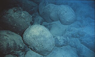
Pillow lavas are lavas that contain characteristic pillow-shaped structures that are attributed to the extrusion of the lava under water, or subaqueous extrusion. Pillow lavas in volcanic rock are characterized by thick sequences of discontinuous pillow-shaped masses, commonly up to one metre in diameter. They form the upper part of Layer 2 of normal oceanic crust.

Pāhoa is a census-designated place (CDP) in the District of Puna in Hawai‘i County, Hawai‘i, United States. The population was 962 at the 2000 census. The population dropped by 1.8% to 945 at the 2010 census.

The Hawaiian Islands are an archipelago of eight major islands, several atolls, numerous smaller islets, and seamounts in the North Pacific Ocean, extending some 1,500 miles from the island of Hawaiʻi in the south to northernmost Kure Atoll. Formerly the group was known to Europeans and Americans as the Sandwich Islands, a name chosen by James Cook in honor of the then First Lord of the Admiralty John Montagu, 4th Earl of Sandwich. The contemporary name is derived from the name of the largest island, Hawaii Island.

A shield volcano is a type of volcano usually composed almost entirely of fluid lava flows. It is named for its low profile, resembling a warrior's shield lying on the ground. This is caused by the highly fluid lava erupted, which travels farther than lava erupted from a stratovolcano, and results in the steady accumulation of broad sheets of lava, building up the shield volcano's distinctive form.

Lōihi Seamount is an active submarine volcano about 35 km (22 mi) off the southeast coast of the island of Hawaii. The top of the seamount is about 975 m (3,000 ft) below sea level. This seamount is on the flank of Mauna Loa, the largest shield volcano on Earth. Lōihi, meaning "long" in Hawaiian, is the newest volcano in the Hawaiian-Emperor seamount chain, a string of volcanoes that stretches over 5,800 km (3,600 mi) northwest of Lōʻihi. Unlike most active volcanoes in the Pacific Ocean that make up the active plate margins on the Pacific Ring of Fire, Lōʻihi and the other volcanoes of the Hawaiian-Emperor seamount chain are hotspot volcanoes and formed well away from the nearest plate boundary. Volcanoes in the Hawaiian Islands arise from the Hawaii hotspot, and as the youngest volcano in the chain, Lōihi is the only Hawaiian volcano in the deep submarine preshield stage of development.

Hawaiʻi Pacific University, commonly referred to as HPU, is a private, and nonsectarian university in Honolulu and Kaneohe, Hawaiʻi. HPU is the largest private university in the central Pacific, most noted for its diverse student body of nearly 5,000 students, representing nearly 65 countries. The school's top academic programs are in Business Administration, Nursing, Biology, Diplomacy and Military Studies, and Social Work.

The Hawaiian–Emperor seamount chain is a mostly undersea mountain range in the Pacific Ocean that reaches above sea level in Hawaii. It is composed of the Hawaiian ridge, consisting of the islands of the Hawaiian chain northwest to Kure Atoll, and the Emperor Seamounts: together they form a vast underwater mountain region of islands and intervening seamounts, atolls, shallows, banks and reefs along a line trending southeast to northwest beneath the northern Pacific Ocean. The seamount chain, containing over 80 identified undersea volcanoes, stretches over 5,800 kilometres (3,600 mi) from the Aleutian Trench in the far northwest Pacific to the Loʻihi seamount, the youngest volcano in the chain, which lies about 35 kilometres (22 mi) southeast of the Island of Hawaiʻi.

Maui Nui or Greater Maui, is a modern geologists' name given to a prehistoric Hawaiian Island built from seven shield volcanoes. Nui means "great/large" in the Hawaiian language.

Coconut Island, or Moku o Loʻe, is a 28-acre island in Kāne'ohe Bay off the island of Oahu in the state of Hawaii, United States. It is a marine research facility of the Hawaii Institute of Marine Biology (HIMB) of the University of Hawaii.

Pele's hair is a form of lava. It is named after Pele, the Hawaiian goddess of volcanoes. It can be defined as volcanic glass fibers or thin strands of volcanic glass. The strands are formed through the stretching of molten basaltic glass from lava, usually from lava fountains, lava cascades, and vigorous lava flows.
Earthquake Research Institute, University of Tokyo is the institute in affiliation with University of Tokyo. It was founded in 1925. Many fellows research on various topics about Seismology and volcanology. The Institute is represented on the national Coordinating Committee for Earthquake Prediction.

The Hawaii hotspot is a volcanic hotspot located near the namesake Hawaiian Islands, in the northern Pacific Ocean. One of the most well-known and heavily studied hotspots in the world, the Hawaii plume is responsible for the creation of the Hawaiian – Emperor seamount chain, a chain of volcanoes over 5,800 kilometres (3,600 mi) long. Four of these volcanoes are active, two are dormant, and more than 123 are extinct, many having since been ground beneath the waves by erosion as seamounts and atolls. The chain extends from south of the island of Hawaiʻi to the edge of the Aleutian Trench, near the eastern edge of Russia.

Submarine eruptions are those volcano eruptions which take place beneath the surface of water. These occur at constructive margins, subduction zones and within tectonic plates due to hotspots. This eruption style is far more prevalent than subaerial activity. For example, it is believed that 70 to 80% of the Earth’s magma output takes place at mid-ocean ridges.
Penguin Bank is the name given to a now-submerged shield volcano of the Hawaiian Islands. Its coral-capped remains lie immediately west of the island of Molokaʻi, under relatively shallow water.
Robert Yonover, born in 1959, is an American scientist and inventor. He was born in Chicago, grew up in Florida, and lives in Honolulu Hawaii. He is an inventor of survival technology used by U.S./Foreign Military.
The Coordinating Committee for Earthquake Prediction (CCEP) in Japan was founded in April 1969, as part of the Geodesy Council's Second Earthquake Prediction Plan, in order to carry out a comprehensive evaluation of earthquake data in Japan. The committee consists of 30 members and meets four times each year, as well as publishing a report on its activities twice each year. The CCEP brings together representatives from 20 governmental bodies and universities engaged in earthquake prediction and research. It has a secretariat within the Ministry of Land, Infrastructure, Transport and Tourism.
Robert Wayne Decker was an American volcanologist.
Peter Edward Baker (1937–2008) was a notable British volcanologist, professor emeritus of Igneous Petrology in the School of Earth Sciences, University of Leeds.


