Related Research Articles

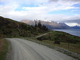
Hawke's Bay is a region on the east coast of New Zealand's North Island. The region is named for Hawke Bay, which was named in honour of Edward Hawke. The region's main centres are the cities of Napier and Hastings, while the more rural parts of the region are served by the towns of Waipukurau, Waipawa, and Wairoa.
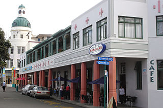
Napier is a city on the eastern coast of the North Island of New Zealand and the seat of the Hawke's Bay region. It is a beachside city with a seaport, known for its sunny climate, esplanade lined with Norfolk pines, and extensive Art Deco architecture. Napier is sometimes referred to as the "Nice of the Pacific", although that is largely outdated and a more common nickname is 'The Art Deco Capital of the world'.

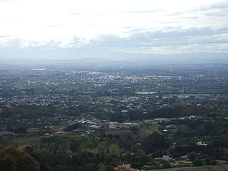
Hastings is an inland city of New Zealand and is one of the two major urban areas in Hawke's Bay, on the east coast of the North Island. The population of Hastings is 51,500, with a further 15,200 people in Havelock North and 2,090 in Clive. Hastings is about 18 kilometres inland of the coastal city of Napier. These two neighbouring cities are often called "The Bay Cities" or "The Twin Cities".
Waipukurau is the largest town in the Central Hawke's Bay District on the east coast of the North Island of New Zealand. It is located on the banks of the Tukituki River, 7 kilometres south of Waipawa and 50 kilometres southwest of Hastings.
Hastings District is a Territorial authority district within the Hawke's Bay Region, on the east coast of the North Island of New Zealand. It covers the southern half of the Hawke's Bay coast, excluding Napier City, which is a separate territorial authority. Hastings District Council is headquartered in the city of Hastings, the district's largest town.
The International Mountain Bicycling Association (IMBA) is a non-profit educational association with a stated mission is to create and preserve trails for mountain bikers worldwide.
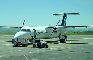
Hawke's Bay Airport, commonly referred to as Napier Airport, is Hawke's Bay's main commercial airport, serving domestic flights to the main centres of Auckland, Wellington and Christchurch, and smaller centres such as Gisborne. The airport is located in the north of Napier and 20.7 km from Hastings.

The Hawke's Bay cricket team, representing the Hawke's Bay region of New Zealand, played first-class cricket between 1883–84 and 1920–21, and competed in the Plunket Shield in the 1914–15 and 1920–21 seasons. The side has continued to appear in minor cricket and now competes in the Hawke Cup competition, where it has been the dominant team from 2020 to 2024.
The Remutaka Rail Trail is a walking and cycling track in the North Island of New Zealand. It runs between Maymorn and Cross Creek, and follows 22 kilometres (14 mi) of the original route of the Wairarapa Line over the Remutaka Range between the Mangaroa Valley and the Wairarapa, including the world-famous Rimutaka Incline. Parts of the trail are also used by vehicles both from the regional council and from forestry companies with tree plantations in the area; members of the public have limited vehicular access from the Kaitoke end to a car park, go-kart track and gun range. Access is also granted by permission to horse riders. Touring coaches have been used upon occasion to convey tourists and other visitors to various parts of the route.
A bicycle carrier, also commonly called a bicycle rack, is a device attached to a vehicle to transport bicycles.

Cycling in New Zealand is the 5th most popular form of active recreation, but a very marginal commuting mode, with the share hovering around 1–3% in most major cities. This is due to a number of factors, principally safety fears.

The New Zealand Cycle Trail project is a New Zealand government initiative, co-funded together with local councils and charitable trusts, which is to build and operate a network of cycle routes through the country.
The Makaroro River is a river of the southern Hawke's Bay region of New Zealand's North Island. It flows southeast from the slopes of the Ruahine Range, meeting the waters of the Waipawa River 12 kilometres (7 mi) west of Tikokino.
The Around the Mountains Cycle Trail is a cycle trail set in the remote wilderness of southern New Zealand. 186 km in length, it can be ridden in either direction, starting at Kingston or Walter Peak and taking three to five days at a relaxed pace to complete. The Around the Mountains Cycle Trail is recognised as one of New Zealand's 23 Great Rides.
Bike On NZ is a not-for-profit organisation in New Zealand that aims to encourage more New Zealanders to cycle. It was started by Paul McArdle and Meg Frater in November 2009, and initially started with 'Bikes in schools' programs that provided bicycles and bicycle tracks on primary school grounds to allow children to learn to ride bikes – with many of the children involved having no cycling experience at all, and with many of the parents of the children being too concerned about their safety to allow them to ride bicycles on public roads. The organisation has since branched out into a variety of other cycling promotion and advocacy, including providing bicycles to encourage 'police on bikes' schemes.

Waitawa Regional Park is a regional park situated on the coast of Tāmaki Strait, east of Auckland, New Zealand. It is located in Franklin in the Auckland Region, near Kawakawa Bay and Clevedon, about 50 kilometres (31 mi) from central Auckland.
The Hawke's Bay Herald-Tribune was a New Zealand newspaper which published from 1937 until 1999. Covering the Hawke's Bay region, it was based in Hastings.
The Mangakino Stream is a tributary of the Waikato River. It flows into Lake Maraetai just upstream of the Mangakino township.

The Hawke's Bay wine region is New Zealand's oldest and second-largest wine-production region, on the east coast of the North Island. Production reached 41,000 tonnes in 2018 from 4,681 hectares of planted vines, representing 10.2% of total national production. Some of the oldest wineries still operating in New Zealand, including Te Mata Estate, Church Road, and Mission Estate, were established in the Hawke's Bay area in the late 19th century. Despite this, it was only established as a geographical indication (GI) in 2018. The GI protects any wine produced within the boundaries of the entire Hawke's Bay Region, but in practice the vineyards are chiefly concentrated in the plains and low hills surrounding the cities of Napier and Hastings.
Napier City Council is the territorial authority of Napier, Hawke's Bay Region, New Zealand.
References
- ↑ "Hawke's Bay Trails". Hawke's Bay Regional Council. Archived from the original on 25 March 2015. Retrieved 21 March 2015.
| | This trail or long-distance path-related article is a stub. You can help Wikipedia by expanding it. |
| | This Hawke's Bay Region geography article is a stub. You can help Wikipedia by expanding it. |