Related Research Articles

The Deschutes River in central Oregon is a major tributary of the Columbia River. The river provides much of the drainage on the eastern side of the Cascade Range in Oregon, gathering many of the tributaries that descend from the drier, eastern flank of the mountains. The Deschutes provided an important route to and from the Columbia for Native Americans for thousands of years, and then in the 19th century for pioneers on the Oregon Trail. The river flows mostly through rugged and arid country, and its valley provides a cultural heart for central Oregon. Today the river supplies water for irrigation and is popular in the summer for whitewater rafting and fishing.

Navajo Dam is a dam on the San Juan River, a tributary of the Colorado River, in northwestern New Mexico in the United States. The 402-foot (123 m) high earthen dam is situated in the foothills of the San Juan Mountains about 44 miles (71 km) upstream and east of Farmington, New Mexico. It was built by the U.S. Bureau of Reclamation (Reclamation) in the 1960s to provide flood control, irrigation, domestic and industrial water supply, and storage for droughts. A small hydroelectric power plant was added in the 1980s.

The Crooked River is a tributary, 125 miles (201 km) long, of the Deschutes River in the U.S. state of Oregon. The river begins at the confluence of the South Fork Crooked River and Beaver Creek. Of the two tributaries, the South Fork Crooked River is the larger and is sometimes considered part of the Crooked River proper. A variant name of the South Fork Crooked River is simply "Crooked River". The Deschutes River flows north into the Columbia River.
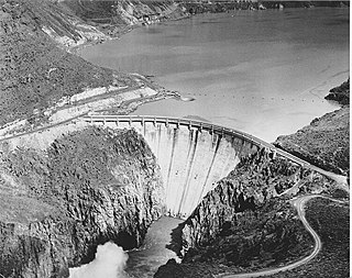
Owyhee Dam is a concrete arch-gravity dam on the Owyhee River in Eastern Oregon near Adrian, Oregon, United States. Completed in 1932 during the Great Depression, the dam generates electricity and provides irrigation water for several irrigation districts in Oregon and neighboring Idaho. At the time of completion, it was the tallest dam of its type in the world. The dam is part of the Owyhee Dam Historic District, which is listed on the National Register of Historic Places.

Wickiup Reservoir is the second-largest reservoir in the U.S. state of Oregon. It is located 60 miles (97 km) southwest of Bend, and is the largest of the Cascade Lakes. Wickiup Reservoir is close to the Twin Lakes, Davis Lake, Crane Prairie Reservoir, Cultus Lake, and Little Cultus Lake. The reservoir is located within the Deschutes National Forest and the Fort Rock Ranger District, near the Cascade Lakes Scenic Byway.

Gerber Dam is a concrete arch dam located 14 miles east of Bonanza, Oregon, and about 12 miles north of the California border, in Klamath County, Oregon.

Central Oregon Irrigation District is a municipal corporation to provide irrigation water for Central Oregon, U.S. The canals serve agricultural and industrial users in the arid lands between Alfalfa, Bend, Redmond, Terrebonne, and Powell Butte. Among its 4,000 or so individual customer accounts, it also provides municipal water to the city of Redmond, neighboring subdivisions, and parks and schools in Bend. The district manages more than 700 miles (1,100 km) of canals serving about 70.3 square miles (182 km2) of lands within a rough area of 280 square miles (730 km2).
Ochoco Dam is a dam in Central Oregon, 6 miles (9.7 km) east of Prineville in Crook County, Oregon, in the United States.

Pelton Dam is a major dam on the Deschutes River in Jefferson County, Oregon, owned and operated as a hydroelectric facility by Portland General Electric, one element of its Pelton Round Butte Project on the Deschutes.

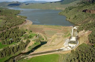
Crawford Dam impounds water for Crawford Reservoir in Delta County, Colorado about a mile south of the town of Crawford. The earthen dam was completed in 1962 by the United States Bureau of Reclamation with a height of 162 feet (49 m) and 580 feet (180 m) long at its crest. It impounds Iron Creek for irrigation flood control, one element of the Smith Fork Project. The dam is owned by the Bureau and operated by the local Crawford Water Conservancy District. When full, Crawford Reservoir has a water surface area of 406 acres (164 ha), about 7 miles (11 km) of shoreline, and a total capacity of 14,395 acre-feet (17,756,000 m3). The main purpose of the facility is to provide farm irrigation, and the size of Crawford Reservoir changes significantly with the seasons. In most years, the lake is full in late Spring and early Summer, but by early Fall, the water level drops enough to leave boat launches high and dry. The low water pool lasts through the Winter until Spring runoff begins to fill the water supply once again.
The reservoir is encompassed within Crawford State Park with Park Headquarters located on a peninsula along the northeastern shore. Recreation opportunities include fishing, boating, camping on 66 campsites, picnicking, swimming, and hiking.
Virginia Smith Dam is a dam in Garfield County, Nebraska, about five miles northwest of Burwell.

Prosser Creek Dam is a dam in Nevada County, California.

Carter Lake Dam is a dam in Larimer County, Colorado.

Bonny Dam is a dam in Yuma County, Colorado, in the eastern part of the state.
Willow Creek Dam is a dam in Lewis and Clark County, Montana.

Kortes Dam is a dam in Carbon County, Wyoming.
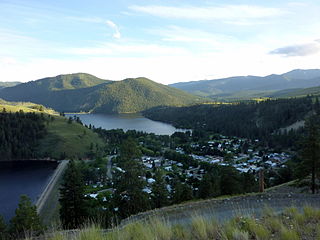
Salmon Lake Dam is a dam in Okanogan County, Washington.

Huntington North Dam is a dam in Emery County, Utah.

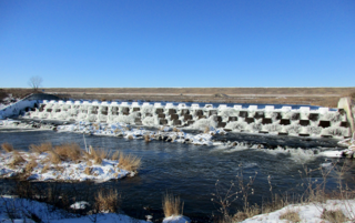
Black Canyon Diversion Dam is a dam in Gem County, Idaho.

The Swalley Irrigation District supplies water to irrigators through a network of pipes and canals fed by the Deschutes River near Bend in the U.S. state of Oregon. The network, begun in 1899, is a closed system with an intake behind North Canal Dam in Bend and a main canal, the Swalley Canal, that runs north from the city for about 13 miles (21 km). The only covered bridge east of the Cascade Range in Oregon crosses the Swalley Canal.
References
- ↑ "Dam details - Haystack Dam - Bureau of Reclamation". Archived from the original on 2012-09-06. Retrieved 2012-08-31.
- ↑ "Project details - Deschutes Project - Bureau of Reclamation". Archived from the original on 2012-09-20. Retrieved 2012-08-31.
- ↑ "WATER SOURCES – North Unit Irrigation District".
- ↑ "Haystack Reservoir, Oregon".
- ↑ "Dam details - Haystack Dam - Bureau of Reclamation". Archived from the original on 2012-09-26. Retrieved 2012-08-31.
44°29′56″N121°09′18″W / 44.49899°N 121.15505°W
| Authority control databases: Geographic |
|---|