Symbols
 Coat of Arms of the Municipality of Hefshuizen
 Flag of the Municipality of Uithuizen (1950–1979) and also Flag of the Municipality of Hefshuizen (1979–1991)
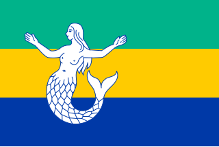
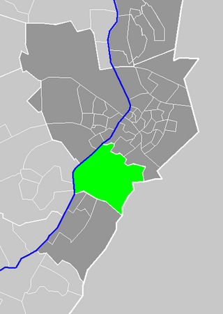
Hefshuizen is a former municipality in the Dutch province of Groningen.
Hefshuizen was created in 1979, in the merger of the former municipalities of Uithuizen and Uithuizermeeden. In 1990, Kantens, Usquert, and Warffum were added, and in 1992, the name of the municipality was changed to Eemsmond. [1]


The flag of San Marino is formed by two equal horizontal bands of white (top) and light blue with the national coat of arms superimposed in the center; the coat of arms has a shield with a closed crown on top, flanked by an oak and laurel wreath, with a scroll below bearing the word LIBERTAS (Freedom). The two colors of the flag represent peace (white) and liberty.
Eemsmond is a former municipality with a population of 15,864 in the north of the province of Groningen in the northeast of the Netherlands. On 1 January 2019 it merged with the municipalities of Bedum, De Marne and Winsum to form the new municipality Het Hogeland.

Winschoten is a city with a population of 18,518 in the municipality of Oldambt in the northeast of the Netherlands. It is the largest city in the region of Oldambt in the province of Groningen which has 38,213 inhabitants.

Uithuizermeeden is a village in the Netherlands, with a population of about 3,200 people. It is part of the municipality of Het Hogeland, close to the Wadden Sea.

Usquert is a village in the Dutch province of Groningen. It is located in the municipality of Het Hogeland. It had a population of around 1,415 in January 2017.
Tegelen is a village in the municipality of Venlo, situated in the Netherlands. It was an independent municipality until 2001, when it was merged into the municipality of Venlo.

Warffum is a village in the Dutch province of Groningen. It is located in the municipality of Het Hogeland. It had a population of around 2,175 in January 2017.

Roodeschool is a community situated in the northeast of Groningen province in the Netherlands and forming part of the municipality of Het Hogeland. It had a population of around 860 in January 2017.

Uithuizen is a village in the Dutch province of Groningen. It is located in the municipality of Het Hogeland. It had a population of 4,885 in January 2017.

The Mayo or Yoreme are an indigenous group in Mexico, living in the northern states of southern Sonora, northern Sinaloa and small settlements in Durango.

Kantens is a village in the Dutch province of Groningen. It is located in the municipality of Het Hogeland, about 16 km north of the city of Groningen. It had a population of around 965 including the surrounding area in January 2017.

Stitswerd is a village in the municipality of Het Hogeland, Groningen, the Netherlands. It had a population of around 45 in January 2017. Stitswerd is located on a wierde near the estuary of the former river Fivel.

Oosteinde is a village in the municipality of Het Hogeland, Groningen, the Netherlands. It is located southeast of Roodeschool, near the river Groote Tjariet. It had a population of around 160 in January 2017.

Oosternieland is a village in the municipality of Het Hogeland, Groningen, the Netherlands. It is located just north of Zijldijk, along the N46 road between the city of Groningen and the Eemshaven seaport. It had a population of around 100 in January 2017.
Oldambt is a municipality with a population of 38,277 in the province of Groningen in the Netherlands. It was established in 2010 by merging the municipalities of Reiderland, Scheemda, and Winschoten. It contains the city of Winschoten and these villages:

Oldenzijl is a small village in Het Hogeland municipality in the Dutch province of Groningen. It had a population of around 45 in January 2017.
Zandeweer is a village in Het Hogeland municipality in the Dutch province of Groningen. It had a population of around 475 in January 2017.

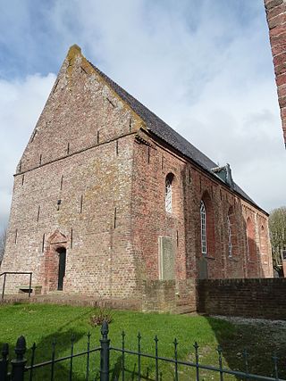
The Jacobikerk organ in Uithuizen in the Dutch province of Groningen was built in 1701 by Arp Schnitger. It has 28 stops which are distributed on two manuals and pedal. The instrument is one of the best preserved Schnitger organs. The organ has been used as a template for newly built organs in the 20th century and for the reconstruction of lost stops of other Schnitger organs.

Het Hogeland is a municipality in the north of the province of Groningen in the northeast of the Netherlands.

Marte Röling is a Dutch artist and actress.
53°24′55″N6°42′02″E / 53.415364°N 6.700459°E
| | This Groningen location article is a stub. You can help Wikipedia by expanding it. |