Reuver is a village in the Dutch province of Limburg. It is located in the municipality of Beesel, about 10 km south of the city of Venlo. The successful metal band Epica comes from Reuver.

Martenshoek is a neighbourhood of Hoogezand and former village in the Dutch province of Groningen. It is located in the municipality of Midden-Groningen, about 2 km west of the town of Hoogezand.

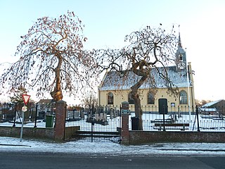
Kruiningen is a village in the Dutch province of Zeeland. It is located in the municipality of Reimerswaal, about 5 km south of the village of Yerseke.

Elkerzee is a hamlet in the Dutch province of Zeeland. It is a part of the municipality of Schouwen-Duiveland, and lies about 1 km south of Scharendijke.

Biessum is a hamlet in the Dutch province of Groningen. It is a part of the municipality of Eemsdelta, and lies about 25 km northeast of Groningen.
Noordwijk is a small village in the municipality of Westerkwartier, in the province of Groningen in the Netherlands, about 3 km north of the town of Marum. Until 2019, it was part of the municipality of Marum. As of 2021, it had a population of 225.

Voorst is a village in the Dutch province of Gelderland. It is located in the municipality of Oude IJsselstreek, about 3 km east of the town of Gendringen.

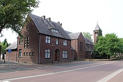
Oostdijk is a village in the Dutch province of Zeeland. It is located in the municipality of Reimerswaal, about 3 km east of the town of Kruiningen.

Eerde is a village in the Dutch province of North Brabant. It is part of the municipality of Meierijstad, located about 500 m west of the built-up area of Veghel and 3 km southwest of the town centre of Veghel. During Operation Market Garden, in September 1944, it changed hands several times between German and American forces but ended up in American hands; the village was severely damaged in the process.

Galder is a village in the Dutch province of North Brabant. It is located in the municipality of Alphen-Chaam 8 km south of the city of Breda.
Helle is a hamlet in the Dutch province of Limburg. It is located in the municipality of Gulpen-Wittem, about 1 km south of the village of Mechelen.
't Zand is a hamlet in the Dutch province of North Brabant. It is located in the municipality of Altena, on the southeastern edge of the village of Sleeuwijk.

't Waar is a village in the province of Groningen in the Netherlands. It is located in the municipality of Oldambt, just north of the village of Nieuw-Scheemda.

Berg is a hamlet in the Dutch province of Limburg. It is located in the municipality of Eijsden-Margraten, on the road between Maastricht and Margraten.
Berg is a hamlet in the Dutch province of Limburg. It is located in the municipality of Peel en Maas, about 2 km west of the center of that village. As of 2021, the population was 115.

Bissen is a village in the Dutch province of Limburg. It is located in the municipality of Gulpen-Wittem, about 2 km (1.2 mi) southwest of the village of Mechelen.

Heikant is a hamlet in the Dutch province of North Brabant. It is located in the municipality of Alphen-Chaam, about 2 km northeast of Chaam.
Offenbeek is a village in the Dutch province of Limburg. It is located in the municipality of Beesel, east of the village of Reuver.

Wahlwiller is a village in the Dutch province of Limburg. It is located in the municipality of Gulpen-Wittem. The village is located south of the Selzerbeek.

Ubachsberg is a village in the Dutch province of Limburg. It is located in the municipality of Voerendaal.