
Břehy is a village in the Pardubice Region of the Czech Republic. It has cca 940 inhabitants. The mayor of the village is Petr Morávek.

The Gothenburg Synagogue at Stora Nygatan, near Drottningtorget, Gothenburg, Sweden, was opened in 1855 according to the designs of the German architect August Krüger. The congregation is Conservative. The synagogue sanctuary has 300 seats.
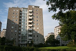
Bellahøj is an area situated 5 kilometres to the northwest of central Copenhagen, Denmark. It features the Bellahøj Houses, a functionalist housing project, as well as parkland with an open-air theatre. The 37 metre high hill situated in Bellahøj Park is the highest point in Copenhagen. The area offers an extensive view over the skyline of Copenhagen.

Dzoraglukh is a town in the Aragatsotn Province of Armenia. The town's church, dedicated to Saint Hovhannes, dates from the 10th to the 12th century.

Jachosze is a village in the administrative district of Gmina Biłgoraj, within Biłgoraj County, Lublin Voivodeship, in eastern Poland. It lies approximately 13 kilometres (8 mi) south-west of Biłgoraj and 84 km (52 mi) south of the regional capital Lublin.
Karolówka is a village in the administrative district of Gmina Frampol, within Biłgoraj County, Lublin Voivodeship, in eastern Poland. It lies approximately 7 kilometres (4 mi) south-east of Frampol, 10 km (6 mi) north of Biłgoraj, and 70 km (43 mi) south of the regional capital Lublin.

Dołhobyczów-Kolonia is a village in the administrative district of Gmina Dołhobyczów, within Hrubieszów County, Lublin Voivodeship, in eastern Poland, close to the border with Ukraine. It lies approximately 3 kilometres (2 mi) east of Dołhobyczów, 30 km (19 mi) south-east of Hrubieszów, and 129 km (80 mi) south-east of the regional capital Lublin.

Pirqaraçuxa is a village in the Agsu Rayon of Azerbaijan.
Pambəyi is a village that forms a part of the municipality of Osakücə, Azerbaijan.
Ksany is a village in the administrative district of Gmina Opatowiec, within Kazimierza County, Świętokrzyskie Voivodeship, in south-central Poland. It lies approximately 5 kilometres (3 mi) north of Opatowiec, 16 km (10 mi) east of Kazimierza Wielka, and 68 km (42 mi) south of the regional capital Kielce.
Śladków Duży is a village in the administrative district of Gmina Chmielnik, within Kielce County, Świętokrzyskie Voivodeship, in south-central Poland. It lies approximately 5 kilometres (3 mi) south-west of Chmielnik and 35 km (22 mi) south of the regional capital Kielce.
Pisary is a village in the administrative district of Gmina Ożarów, within Opatów County, Świętokrzyskie Voivodeship, in south-central Poland. It lies approximately 11 kilometres (7 mi) south of Ożarów, 20 km (12 mi) east of Opatów, and 78 km (48 mi) east of the regional capital Kielce.
Kaniegue is a commune in the Cercle of San in the Ségou Region of Mali. The principal town lies at Dioundiou Konkankan. As of 1998 the commune had a population of 5,559.
Szelewo is a village in the administrative district of Gmina Główczyce, within Słupsk County, Pomeranian Voivodeship, in northern Poland. It lies approximately 8 kilometres (5 mi) south-east of Główczyce, 31 km (19 mi) north-east of Słupsk, and 80 km (50 mi) west of the regional capital Gdańsk.
Toprzyny is a village in the administrative district of Gmina Górowo Iławeckie, within Bartoszyce County, Warmian-Masurian Voivodeship, in northern Poland, close to the border with the Kaliningrad Oblast of Russia. It lies approximately 12 kilometres (7 mi) north-east of Górowo Iławeckie, 19 km (12 mi) north-west of Bartoszyce, and 64 km (40 mi) north of the regional capital Olsztyn.

The Danish War Museum is a museum of military history and arms on Slotsholmen in central Copenhagen, Denmark. It is located in Christian IVs arsenal Tøjhuset, from which it takes its former name. On 1 July 2018, the name was changed from the Royal Danish Arsenal Museum to The Danish War Museum, in order to make it easier for guest to discern the nature of the museum.
Eichert is a mountain of Saxony, southeastern Germany.

Pikavere, Pärnu County is a village in Lääneranna Parish, Pärnu County in southwestern Estonia.

Triigi is a village in Saaremaa Parish, Saare County in western Estonia.
El Mezerra is a town and commune in Tébessa Province in north-eastern Algeria.
