Scandinavia is a region in Northern Europe, with strong historical, cultural, and linguistic ties. The term Scandinavia in local usage covers the three kingdoms of Denmark, Norway, and Sweden. The majority national languages of these three, belong to the Scandinavian dialect continuum, and are mutually intelligible North Germanic languages. In English usage, Scandinavia also sometimes refers to the Scandinavian Peninsula, or to the broader region including Finland and Iceland, which is always known locally as the Nordic countries.

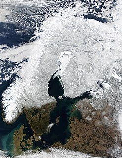
The Scandinavian Peninsula is a peninsula of Eurasia located in Northern Europe, which roughly comprises the mainland of Sweden, the mainland of Norway, and the northwestern area of Finland.

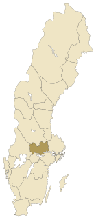
Dalarna County is a county or län in middle Sweden (Svealand). It borders the counties of Uppsala, Jämtland, Gävleborg, Västmanland, Örebro and Värmland. It is also bordered by the Norwegian counties of Hedmark and Trøndelag in the west.

Kiruna is the northernmost town in Sweden, situated in the province of Lapland. It had 17,002 inhabitants in 2016 and is the seat of Kiruna Municipality in Norrbotten County.
Tourism in Sweden made up a relatively small part of the Swedish economy in 2011 at 2.9% of the country's GDP; at this time, tourism brought in 264 billion Swedish krona, 98.8 billion of which was foreign visitor expenditure in Sweden. 7.1% of Swedish household income is spent on domestic tourism.

Narvik (help·info) (Norwegian) or Áhkanjárga (Northern Sami) is the third-largest municipality in Nordland county, Norway by population. The administrative centre of the municipality is the town of Narvik. Some of the notable villages in the municipality include Ankenesstranda, Beisfjord, Bjerkvik, Bjørnfjell, Elvegård, Skjomen, Håkvik, Hergot, Straumsnes, and Vidrek. The Elvegårdsmoen army camp is located near Bjerkvik.
Västmanland is a historical Swedish province, or landskap, in middle Sweden. It borders Södermanland, Närke, Värmland, Dalarna and Uppland.

Gästrikland (help·info) is a historical province or landskap on the eastern coast of Sweden. It borders Uppland, Västmanland, Dalarna, Hälsingland and the Gulf of Bothnia. Gästrikland is the southernmost of the Norrland provinces.

Medelpad is a historical province or landskap in the north of Sweden. It borders Hälsingland, Härjedalen, Jämtland, Ångermanland and the Gulf of Bothnia.

Kebnekaise is the highest mountain in Sweden. The Kebnekaise massif, which is part of the Scandinavian Mountains, has two main peaks, of which the southern, glaciated one is highest at 2,097.5 metres (6,882 ft) above sea level as of August 2014. The northern peak is 2,096.8 metres (6,879 ft) and free of ice. Kebnekaise lies in Swedish Lapland, about 150 kilometres (93 mi) north of the Arctic Circle and west of Kiruna near the Kungsleden hiking trail between Abisko and Hemavan.

A fell is a high and barren landscape feature, such as a mountain range or moor-covered hills. The term is most often employed in Fennoscandia, the Isle of Man, parts of Northern England, and Scotland.

The Alpine orogeny or Alpide orogeny is an orogenic phase in the Late Mesozoic (Eoalpine) and the current Cenozoic that has formed the mountain ranges of the Alpide belt. These mountains include the Atlas, the Rif, the Baetic Cordillera, the Cantabrian Mountains, the Pyrenees, the Alps, the Apennine Mountains, the Dinaric Alps, the Hellenides, the Carpathians, the Balkan Mountains and the Rila-Rhodope massif, the Taurus, the Armenian Highlands, the Caucasus, the Alborz, the Zagros, the Hindu Kush, the Pamir, the Karakoram, and the Himalayas. Sometimes other names occur to describe the formation of separate mountain ranges: for example Carpathian orogeny for the Carpathians, Hellenic orogeny for the Hellenides or the Himalayan orogeny for the Himalayas.

The High Coast is a part of the coast of Sweden on the Gulf of Bothnia, in the municipalities of Kramfors, Härnösand and Örnsköldsvik, notable as an area for research on post-glacial rebound and eustacy, in which the land rises as the covering glaciers melt, a phenomenon first recognised and studied there. Since the last ice age, the land has risen 300 m, which accounts for the region's unusually tall cliffs. The High Coast is part of the Swedish/Finnish High Coast/Kvarken Archipelago World Heritage Site.

Femunden is Norway's third largest lake and the second largest natural lake in Norway. It is located in Hedmark and Trøndelag counties in Norway, just 13 kilometres (8.1 mi) west of the border with Sweden. The lake lies primarily in the municipality of Engerdal and also smaller parts are located in the municipalities of Os (Hedmark) and Røros (Trøndelag). Femundsmarka National Park borders the northeastern part of the lake.

Gresvatnet (Norwegian) or Gräsvattnet (Swedish) or Graesiejaevrie (Southern Sami) is a lake on the border between Norway and Sweden. Most of the lake lies in Hemnes Municipality in Nordland county (Norway) and then a small portion crosses the border into Storuman Municipality in Västerbotten County (Sweden). The lake lies about 25 kilometres (16 mi) east of the village of Korgen, and just a few kilometres northeast of the mountain Oksskolten and the Okstindbreen glacier. The lake is one of the upper reservoirs for the Bjerka Hydroelectric Power Station.

Raudvatnet is a lake in the municipality of Rana in Nordland county, Norway. The European route E12 highway passes along the northern and eastern shores of the lake between the town of Mo i Rana and the border with Sweden. A Red cross hut (Rauvasshytta) is located east of the lake Raudvatnet. Water flows into the lake Raudvatnet primarily from the nearby lake Tverrvatnet to the south. From Raudvatnet, the water flows into the river Tverråga, a tributary to the main river Ranelva.

Sarektjåkkå is the second highest mountain in Sweden and the highest mountain in the Laponian area at 2.089 kilometres (6,850 ft) AMSL. The mountain is located close to the eastern border of Sarek National Park, about 23 kilometres (14 mi) south-west of Suorva.
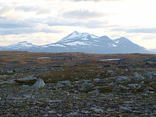
The Scandinavian Mountains or the Scandes is a mountain range that runs through the Scandinavian Peninsula. The Scandinavian Mountains are often erroneously thought to be equivalent to the Scandinavian Caledonides, an ancient mountain range and orogen covering roughly the same area. The western sides of the mountains drop precipitously into the North Sea and Norwegian Sea, forming the fjords of Norway, whereas to the northeast they gradually curve towards Finland. To the north they form the border between Norway and Sweden, still reaching 2,000 metres (6,600 ft) high at the Arctic Circle. The mountain range just touches northwesternmost Finland, but are scarcely more than hills at their northernmost extension at the North Cape (Nordkapp).