Related Research Articles
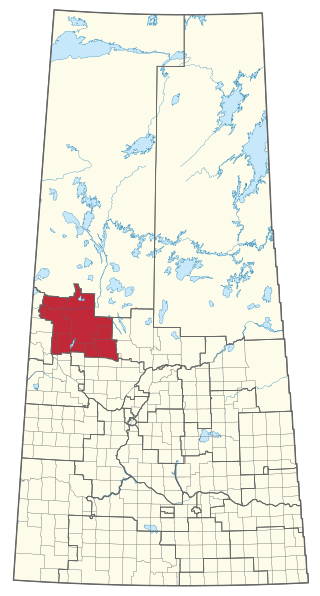
Meadow Lake is a provincial electoral district for the Legislative Assembly of Saskatchewan, Canada. Incorporated as a city in 2009, Meadow Lake is the largest centre in the constituency.
Molanosa is a small isolated community located in Northern Saskatchewan, approximately 70 kilometres south of La Ronge near the northern end of Montreal Lake. It is considered the geographic centre of Saskatchewan.
Canoe Lake 165 is an Indian reserve of the Canoe Lake Cree First Nation in the boreal forest of northern Saskatchewan, Canada. Its location is on Canoe Lake approximately thirty miles west of Beauval, within the ancient hunting grounds of the Woodland Cree. In the 2016 Canadian Census, it recorded a population of 912 living in 250 of its 273 total private dwellings. In the same year, its Community Well-Being index was calculated at 53 of 100, compared to 58.4 for the average First Nations community and 77.5 for the average non-Indigenous community. The reserve includes the settlement of Canoe Narrows. The name of the reserve and the settlement in Cree is nêhiyaw-wapâsihk ᓀᐦᐃᔭᐤ ᐘᐹᓯᕽ.

Turtleford is a town in the rural municipality of Mervin No. 499, in the Canadian province of Saskatchewan. Turtleford is located on Highway 26 near the intersection / concurrency with Highway 3 and Highway 303. The nearest large communities are North Battleford and Lloydminster. The Turtle River runs through Turtleford, and nearby are Bright Sand Lake and Turtle Lake.
Dorintosh is a village in the Canadian province of Saskatchewan within the Rural Municipality of Meadow Lake No. 588 and Census Division No. 17.
Glaslyn is a village in the Canadian province of Saskatchewan within the Rural Municipality of Parkdale No. 498 and Census Division No. 17. The village is located 67 km north of the City of North Battleford and 91 km south of Meadow Lake at the intersection of Highway 4 and Highway 3.
Makwa is a village in the Canadian province of Saskatchewan within the Rural Municipality of Loon Lake No. 561 and Census Division No. 17.

Meota is a village in the Canadian province of Saskatchewan within the Rural Municipality of Meota No. 468 and Census Division No. 17. The village name is derived from the Cree phrase Meotate or Mo-Was-In-Ota, meaning "good place to camp" or "it is good here."
Crystal Hill is a hamlet in Terrell Rural Municipality No. 101 in the province of Saskatchewan, Canada. The hamlet is located 21 km east of Highway 36 on Highway 713. Very little remains of Crystal Hill.

Lenore Lake is a partly saline lake in the Canadian province of Saskatchewan. It is part of the Lenore Lake Basin, which includes several saline lakes as well as the freshwater St. Brieux and Burton Lakes. The basin has no natural outlet. The lake is within the aspen parkland ecozone of Saskatchewan. Lenore Lake was designated a migratory bird sanctuary in 1925. Raven Island, located at the southern end of Lenore Lake, is a National Wildlife Area of Canada.

Canoe Lake 165B is an Indian reserve of the Canoe Lake Cree First Nation in Saskatchewan. It is 22 miles southwest of Île-à-la-Crosse.

Saulteaux 159A is an Indian reserve of the Saulteaux First Nation in Saskatchewan. It is 48 miles north of North Battleford, and on the north shore of Birsh Lake. In the 2016 Canadian Census, it recorded a population of 26 living in 7 of its 10 total private dwellings.
Antelope Lake is an endorheic lake in the south-west corner of the Canadian province of Saskatchewan. The lake is in the Prairie Pothole Region of North America, which extends throughout three Canadian provinces and five U.S. states, and within Palliser's Triangle and the Great Plains ecoregion of Canada. The primary inflow for the lake is Bridge Creek, which originates to the south in the Cypress Hills at an elevation of over 1,000 m (3,300 ft) above sea level.

Spruce River, also called Little Red River, is a river in the north-central region of the Canadian province of Saskatchewan. It begins in the Waskesiu Hills in Prince Albert National Park and flows generally in a southward direction through boreal forests, glacier carved hills and valleys, muskeg, and prairie en route to the North Saskatchewan River at the east end of the city of Prince Albert.
Cumberland Island, also known as Pine Island, is a small island in the Saskatchewan River Delta in the east-central region of the Canadian province of Saskatchewan. The Saskatchewan River Delta is one of the largest active inland deltas in North America. Cumberland Island is situated between Cumberland Lake to the north and the Saskatchewan River to the south. The Tearing River runs along the eastern edge of the island and Bigstone River along the western edge. The Bigstone River separates Cumberland Island from Spruce Island to the west. The island is in the Mid-Boreal Lowland region, which consists of mixed coniferous and deciduous forests of white and black spruce, jack pine, tamarack, trembling aspen, balsam poplar, and balsam fir.
Birchbark Lake is a lake in the central part of the Canadian province of Saskatchewan. Most of the western half of the lake is in the RM of Paddockwood No. 520, while the eastern side is in the RM of Torch River No. 488. A provincial recreation site is located on the south-eastern shore of the lake and access is from a grid road connecting to Highway 55.
Little Loon Lake is a recreational lake in the Canadian province of Saskatchewan. The lake is in the RM of Parkdale No. 498 and near the headwaters of Jackfish Creek in the boreal transition zone. Jackfish Creek flows into Jackfish Lake, which is connected to the North Saskatchewan River via Jackfish River. At 5 kilometres (3.1 mi) to the west, Glaslyn is the closest community to Little Loon Lake. On the southern shore of the lake is Little Loon Regional Park and access to the lake and its amenities is from Highway 3.
Reid Lake, also known as Duncairn Reservoir, is a man-made reservoir in the Canadian Province of Saskatchewan. Reid Lake was formed with the construction of the Duncairn Dam in a glacial meltwater channel along the course of Swift Current Creek in 1942. The reservoir was originally built to supply water for the city of Swift Current, for irrigation projects, and to regulate Swift Current Creek levels downstream. The entire lake is part of the Duncairn Reservoir Migratory Bird Sanctuary.
Courtenay Lake is a lake in the Canadian province of Saskatchewan. It is located in the north-eastern corner of Northern Saskatchewan Administration District and set in a forest of jack pine. Most of the eastern shore is part of a provincial campground. Access to the lake and park is from Highway 905. The only service near the lake is Km 147 Lamp Lighters Lodge, which is a motel, gas station, and restaurant on Highway 905.
Midnight Lake is a lake in the Canadian province of Saskatchewan. It is located in the upland that separates the Saskatchewan and Churchill River drainage basins. The lake sits in the transition zone between the boreal forest and aspen parkland ecozones and is at the centre of an Important Bird Area (IBA) of Canada. Access is from Highway 4
References
- ↑ "Helena Lake, Saskatchewan, Canada". Mindat.org. mindat.org and the Hudson Institute of Mineralogy. Retrieved 31 May 2023.
| | This article about a location in the Census Division No. 17 of Saskatchewan is a stub. You can help Wikipedia by expanding it. |