Helleh River

Last updated
Catchment area of Helleh River (in deep blue) IranCatchKhF5.svg
Catchment area of Helleh River (in deep blue)

The Helleh is a river which is formed by the confluence of the Shapur River and the Dalaki River which run from the Zagros Mountains. At the confluence, which is near the city of Bushehr, there are important wetlands for migrating birds. [1] The Helleh River enters the Persian Gulf at the north end of Bushehr Bay where it forms a delta. [2]

Related Research Articles

<span class="mw-page-title-main">Geography of Iran</span> Geographical features of Iran

Geographically, the country of Iran is located in West Asia and borders the Caspian Sea, Persian Gulf, and Gulf of Oman. Topographically, it is predominantly located on the Persian Plateau. Its mountains have impacted both the political and the economic history of the country for several centuries. The mountains enclose several broad basins, on which major agricultural and urban settlements are located. Until the 20th century, when major highways and railroads were constructed through the mountains to connect the population centers, these basins tended to be relatively isolated from one another.

<span class="mw-page-title-main">Bushehr</span> City in Bushehr province, Iran

Bushehr, also known as Bandar-e-Bushehr, is a city in the Central District of Bushehr County, Bushehr province, Iran. It is a port city and the capital of the province, county, and district.

<span class="mw-page-title-main">Tigris–Euphrates river system</span> River system in the Middle East

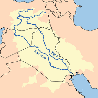
The Tigris–Euphrates river system is a large river system in Western Asia that discharges into the Persian Gulf. Its principal rivers are the Tigris and Euphrates, along with smaller tributaries.

<span class="mw-page-title-main">Zabol</span> City in Sistan and Baluchestan province, Iran

Zabol is a city in, and the capital of, the Central District of Zabol County, Sistan and Baluchestan province, Iran, and also serves as capital of the county. Zabol is near the border with Afghanistan. Referred to as Sistan until the late 1920s, the city was renamed Zabol by Reza Shah Pahlavi.

<span class="mw-page-title-main">Bushehr province</span> Province of Iran

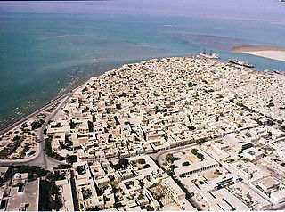
Bushehr Province is one of the 31 provinces of Iran. It is in the south of the country, with a long coastline on the Persian Gulf. The city of Bushehr is the provincial capital. At the 2006 census, the province's population was 886,490 in 188,762 households. The following census in 2011 counted 1,032,949 people in 246,742 households. At the 2016 census, the province's population was 1,163,400 in 321,826 households.

<span class="mw-page-title-main">Snohomish River</span> River in northwest Washington, United States

The Snohomish River is a river in Snohomish County, Washington, formed by the confluence of the Skykomish and Snoqualmie rivers near Monroe. It flows northwest entering Port Gardner Bay, part of Puget Sound, between Everett and Marysville. The Pilchuck River is its main tributary and joins the river at Snohomish. The river system drains the west side of the Cascade Mountains from Snoqualmie Pass to north of Stevens Pass.

<span class="mw-page-title-main">Gudgenby River</span> River in Australian Capital Territory, Australia

The Gudgenby River, a perennial river that is part of the Murrumbidgee catchment within the Murray–Darling basin, is located in the Australian Capital Territory, Australia.

<span class="mw-page-title-main">Pennefather River</span> River in Queensland, Australia

The Pennefather River is a river located on the western Cape York Peninsula in Far North Queensland, Australia.

<span class="mw-page-title-main">Bushehr Airport</span> Airport in Bushehr, Iran

Bushehr Airport is a joint civil and military international airport in Bushehr, Iran.

<span class="mw-page-title-main">Nurabad, Fars</span> City in Fars province, Iran

Nurabad is a city in the Central District of Mamasani County, Fars province, Iran, serving as both capital of the district and of the county. Nurabad is 58.7 kilometres (36.5 mi) from Kazerun, 80.5 kilometres (50.0 mi) from Yasuj, Kohgiluyeh and Boyer-Ahmad province, 87.8 kilometres (54.6 mi) from Dogonbadan, Kohgiluyeh and Boyer-Ahmad, and 100.2 kilometres (62.3 mi) from Borazjan, Bushehr province.

<span class="mw-page-title-main">Bushehr Nuclear Power Plant</span> Power station in Bushehr County, Iran

The Bushehr Nuclear Power Plant is a nuclear power plant in Iran 1,200 kilometres (750 mi) south of Tehran, between the fishing villages of Halileh and Bandargeh along the Persian Gulf.

Khormoj is a city in, and the capital of, the Central District of Dashti County, Bushehr province, Iran, and also serves as capital of the county.

Nakhl Taqi is a city in the Central District of Asaluyeh County, Bushehr province, Iran.

<span class="mw-page-title-main">Weir River (Massachusetts)</span> River in the United States

Weir River is a short stream and estuary that empties into Hingham Bay, part of Boston Harbor in Massachusetts, United States. The name is attributed to the location of a fishing weir in the stream. The river gives its name to a larger watershed and Weir River Farm, a park and nature reserve owned by The Trustees of Reservations.

<span class="mw-page-title-main">Karuvannur River</span> River in India

The Karuvannur River is the fourth largest river in Thrissur District of Kerala. The river is formed by the confluence of the Kurumali river and Manali river.

Helleh va Delleh is a village in Anaqcheh Rural District, in the Central District of Ahvaz County, Khuzestan Province, Iran. At the 2006 census, its population was 173, in 35 families.

The Mission River is a river in Far North Queensland, Australia.

<span class="mw-page-title-main">Khormoj Castle</span> Castle in Bushehr Province, Iran

Khormoj castle is a historical castle located in Dashti County in Bushehr Province, The longevity of this fortress dates back to the Qajar dynasty.

<span class="mw-page-title-main">Bardestan Castle</span> Castle in Bushehr Province, Iran

Bardestan castle is a historical castle located in Deyr County in Bushehr Province, The longevity of this fortress dates back to the Historical periods after Islam.

<span class="mw-page-title-main">Zohreh River</span> River in southwestern Iran

The Zohre is a river in southwestern Iran. It is formed at the confluence of the rivers Rudkhaneye-Fekhlian, and Rude-Tenge-Shu, which flow from the southern slopes of the Zagros mountains northwest of the city of Nurabad, Fars to the south-west of Yasuj, in the Fars province. The stream rises at an altitude of approximately 2,450 m, and flows in the east-west direction for 490 km.

References

  1. "Helleh Wetland". Iran Tourism and Touring Organization. Retrieved 6 January 2017.
  2. "Shoreline Classification". Monitoring & Modeling Studies of Iranian Coasts. Ports & Maritime Organization. Retrieved 6 January 2018.