
Henrico County, officially the County of Henrico, is a county located in the Commonwealth of Virginia in the United States. As of the 2020 census, the population was 334,389 making it the fifth-most populous county in Virginia. Henrico County is included in the Greater Richmond Region. There is no incorporated community within Henrico County; therefore, there is no incorporated county seat either. Laurel, an unincorporated CDP, serves this function.

Short Pump is a census-designated place (CDP) in Henrico County, Virginia, United States. It is a suburb of Richmond, Virginia. The population was 30,626 at the 2020 census.
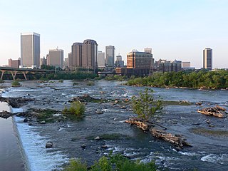
The Greater Richmond Region, also known as the Richmond metropolitan area or Central Virginia, is a region and metropolitan area in the U.S. state of Virginia, centered on Richmond. The U.S. Office of Management and Budget (OMB) defines the area as the Richmond, VA Metropolitan Statistical Area, a metropolitan statistical area (MSA) used by the U.S. Census Bureau and other entities. The OMB defines the area as comprising 17 county-level jurisdictions, including the independent cities of Richmond, Petersburg, Hopewell, and Colonial Heights. As of 2020, it had a population of 1,314,434, making it the 44th largest MSA in the country.

Sandston is a census-designated place (CDP) in Henrico County, Virginia, United States, just outside the state capital of Richmond. The population as of the 2010 Census was 7,571. It was designated a Historic District by Henrico County in 2021.

The West End is a part of Richmond, Virginia. Definitions of the bounds of the West End vary, it may include only the western part of the city of Richmond or extend as far as western Henrico County. As there is no one municipal organization that represents this specific region, the boundaries are loosely defined as being north of the James River, west of I-195, and south of Broad Street. Historically, the Richmond neighborhoods of the Fan and the Museum District were a part of the West End. A primary conduit through the West End is Interstate 64.
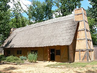
The "Citie of Henricus"—also known as Henricopolis, Henrico Town or Henrico—was a settlement in Virginia founded by Sir Thomas Dale in 1611 as an alternative to the swampy and dangerous area around the original English settlement at Jamestown, Virginia. Named for Henry, Prince of Wales (1594–1612), the eldest son of King James I, Henricus is located on a former curl of the James River about 12 miles southeast of the modern city of Richmond, Virginia or 15 miles from the fall line of the James River.
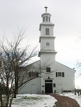
St. John's Church is an Episcopal church located at 2401 East Broad Street in Richmond, Virginia, United States. Formed from several earlier parishes, St. John's is the oldest church in the city of Richmond, Virginia. It was built in 1741 by William Randolph's son, Colonel Richard Randolph; the Church Hill district was named for it. It was the site of two important conventions in the period leading to the American Revolutionary War, and is famous as the location where American Founding Father Patrick Henry gave his memorable speech at the Second Virginia Convention, closing with the often-quoted demand, "Give me liberty, or give me death!" The church is designated as a National Historic Landmark.

Varina is a former unincorporated community and current magisterial district in the easternmost portion of Henrico County, Virginia, United States.
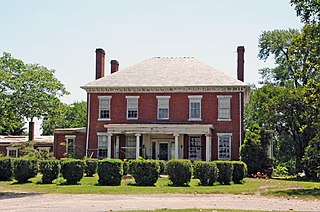
Varina Farms, also known as Varina Plantation or Varina Farms Plantation or Varina on the James, is a plantation established in the 17th century on the James River about 10 miles (16 km) south of Richmond, Virginia. An 820-acre (330 ha) property was listed on the National Register of Historic Places in 1977 as "Varina Plantation". At that time it included two contributing buildings and one other contributing site.

The Henrico County Public Schools school system is a Virginia school division that operates as an independent branch of the Henrico County, Virginia county government and administers public schools in the county. Henrico County Public Schools has five International Baccalaureate schools – John Randolph Tucker High School, Henrico High School, Fairfield Middle School, Tuckahoe Middle School and George H. Moody Middle School.
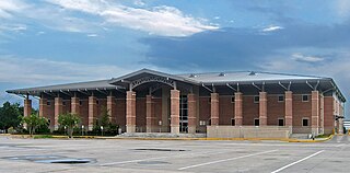
Harris County Public Library (HCPL) is a public library system serving Harris County, Texas, United States.

The East End of Richmond, Virginia is the quadrant of the City of Richmond, Virginia, and more loosely the Richmond metropolitan area, east of the downtown.
Henrico is the name used by the U.S. Postal Service for several ZIP code areas in unincorporated parts of Henrico County, Virginia, surrounding the city of Richmond. "Other acceptable cities" listed by the USPS for parts of Henrico are Richmond, Highland Springs, Regency, and Ridge, whereas Millers, Montrose, Montrose Heights, Staples Mill, Tuckahoe, Varina, and Westbury are alternate names for portions of Henrico that are not recommended for use in mailing addresses.
Central Rappahannock Regional Library (CRRL) is a public library system that serves the city of Fredericksburg and Spotsylvania, Stafford, and Westmoreland counties in Virginia. The library system is within Region 5 of Virginia Library Association (VLA).
The Eastern Shore Public Library is a library system that serves counties of Accomack and Northampton counties in Virginia. The library system is within Region 3 of the Virginia Library Association (VLA).
The Jefferson-Madison Regional Library system serves Albemarle, Greene, Louisa, and Nelson counties and City of Charlottesville. The library system is within Region 6 of Virginia Library Association (VLA) regions.
Blackwater Regional Library system serves the counties of Isle of Wight, Southampton, Surry, Sussex, and the city of Franklin in Virginia. The library system is within Region 3 of Virginia Library Association (VLA). According to FY 2015 Statistical Data for Virginia Public Libraries, the Blackwater Regional Library serves a population of 82,763.
Appomattox Regional Library system serves the city of Hopewell and Prince George and Dinwiddie counties in Virginia. The library system is within Region 2 of Virginia Library Association (VLA).

The Arlington Public Library is a public library system located in Arlington County, Virginia. The library system includes nine locations that serve 214,373 people.
The Blue Ridge Regional Library (SBRL) is a library system that serves counties in Virginia. The library system is within Region 2 of the Virginia Library Association (VLA).


