Jackson County is a county in the U.S. state of Minnesota. As of the 2020 census, the population was 9,989. Its county seat is Jackson.

Trout Lake Township is located in north central Minnesota in Itasca County, United States. It is bordered by the City of Coleraine to the west and north, City of Bovey on the north, an unorganized township on the east, and Blackberry Township to the south. Town government was adopted on March 6, 1894. The population was 1,056 at the 2020 census.

The wood duck or Carolina duck is a species of perching duck found in North America. The drake wood duck is one of the most colorful North American waterfowls.
Ducks Unlimited (DU) is an American 501(c)(3) nonprofit organization dedicated to the conservation of wetlands and associated upland habitats for waterfowl, other wildlife, and people. It has had a membership of around 700,000 since January 2013.

Waterfowl hunting is the practice of hunting ducks, geese, or other waterfowl for food and sport.

The Minnesota Department of Natural Resources, or Minnesota DNR, is the agency of the U.S. state of Minnesota charged with conserving and managing the state's natural resources. The agency maintains areas such as state parks, state forests, recreational trails, and recreation areas as well as managing minerals, wildlife, and forestry throughout the state. The agency is divided into six divisions - Ecological & Water Resources, Enforcement, Fish & Wildlife, Forestry, Lands & Minerals, and Parks & Trails.

The Saint Francis River is a 79.0-mile-long (127.1 km) tributary of the Elk River in east-central Minnesota in the United States. Via the Elk River, it is part of the watershed of the Mississippi River, draining an area historically characterized by mixed hardwood and coniferous forests on flat to rolling till plains.
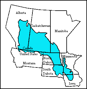
The Prairie Pothole Region is an expansive area of the northern Great Plains that contains thousands of shallow wetlands known as potholes. These potholes are the result of glacier activity in the Wisconsin glaciation, which ended about 10,000 years ago. The decaying ice sheet left behind depressions formed by the uneven deposition of till in ground moraines. These depressions are called potholes, glacial potholes, kettles, or kettle lakes. They fill with water in the spring, creating wetlands, which range in duration from temporary to semi-permanent. The region covers an area of about 800,000 sq. km and expands across three Canadian provinces and five U.S. states. The hydrology of the wetlands is variable, which results in long term productivity and biodiversity. The PPR is a prime spot during breeding and nesting season for millions of migrating waterfowl.

Horicon Marsh is a marsh located in northern Dodge and southern Fond du Lac counties of Wisconsin. It is the site of both a national and a state wildlife refuge. The silted-up glacial lake is the largest freshwater cattail marsh in the United States.

Malheur Lake is one of the lakes in the Malheur National Wildlife Refuge in Harney County in the U.S. state of Oregon. Located about 18 miles (29 km) southeast of Burns, the lake is marsh fed by the Donner und Blitzen River from the south and the Silvies River from the north. Malheur Lake periodically overflows into Mud Lake to the west and thence to Harney Lake, the sink of Harney Basin.

Oak Hammock Marsh is a marsh and a wildlife management area located 34 kilometres (21 mi) north of Winnipeg, Manitoba, Canada. The WMA is considered to be a Class IV protected area under the IUCN protected area management categories. The marsh is recognized as an Important Bird Area (IBA) for its globally significant numbers of waterfowl and shorebirds. It is a designated Ramsar site due to its international importance as a breeding and staging area for waterfowl and other migratory birds. It is 3,578.47 hectares in size.

The natural history of Minnesota covers many plant and animal species in the U.S. state of Minnesota. The continental climate and location of Minnesota at the physiographic intersection of the Laurentian and the Interior Plains influences its plant and animal life. Three of North America's biomes converge in Minnesota: prairie grasslands in the southwestern and western parts of the state, the eastern temperate deciduous forests in the east-central and the southeast, and the coniferous forest in the north-central and northeast.

A water bird, alternatively waterbird or aquatic bird, is a bird that lives on or around water. In some definitions, the term water bird is especially applied to birds in freshwater ecosystems, although others make no distinction from seabirds that inhabit marine environments. Some water birds are more terrestrial while others are more aquatic, and their adaptations will vary depending on their environment. These adaptations include webbed feet, beaks, and legs adapted to feed in the water, and the ability to dive from the surface or the air to catch prey in water.
The North American Waterfowl Management Plan (NAWMP) is an international plan to conserve waterfowl and migratory birds in North America. It was established in 1986 by Canada and the United States, and expanded to include Mexico in 1994.
The Manitoba Watershed District Program is a provincial-municipal partnership directed to the conservation and management of water and soil resources. There are 14 watershed districts including more than 130 municipalities covering almost all of the agricultural areas of Manitoba, Canada. The Province provides substantial funding and general guidance but the programs are developed and administered locally. The districts spend more than $8 million each year on a wide variety of conservation programs.

The Windom Wetland Management District acquires and manages Waterfowl Production Areas, enforces wetland easements, and provides conservation assistance to landowners in 12 southwestern Minnesota counties. The landscape is dominated by intense, row-crop agriculture, which has led to the drainage of most wetlands and widespread water quality problems. Deteriorating drainage tile systems and the abundance of historic wetland basins provide unlimited opportunities for wetland restorations.
Christina Lake is a lake situated in west-central Minnesota. It is primarily situated in Douglas County, with its western part extending into Grant County. The lake measures 3,978 acres (16.10 km2), with an average depth of 4 ft (1.2 m). The lake is a designated Wildlife Management Lake and is nationally recognized for providing a staging area for migrating waterfowl, particularly the canvasback. Literally tens-of-thousands of waterfowl can be seen clustered in huge rafts across the expanse of the lake during peak migration, making the spot a primary destination for birders and waterfowlers.

The Summer Lake Wildlife Area is a 29.6-square-mile (77 km2) wildlife refuge located on the northwestern edge of the Great Basin drainage in south-central Oregon. It is administered by the Oregon Department of Fish and Wildlife. The refuge is an important stop for waterfowl traveling along the Pacific Flyway during their spring and fall migrations. The Summer Lake Wildlife Area also provides habitat for shorebirds and other bird species as well as wide variety of mammals and several fish species. The Ana River supplies the water for the refuge wetlands.
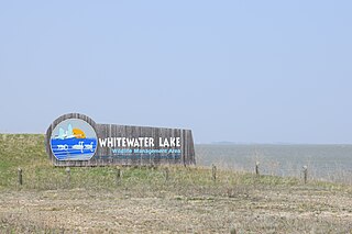
Whitewater Lake is a lake in the Canadian province of Manitoba located between Boissevain and Deloraine. It is an endorheic basin and more marsh than lake. Whitewater Lake was previously called White Lake due to the color of the salt flats exposed during dry periods. Whitewater Lake covers approximately 22,000 acres on average and only reaches depths of about 2 metres (6.6 ft). The lake is fed by several small streams which flow into it from the Turtle Mountains but has no natural outflow.
