
Herscha Hill is an elevated landform in Aberdeenshire, Scotland. Neolithic archaeological finds have been made at this location. [1]
Herscha Hill is an elevated landform in Aberdeenshire, Scotland. Neolithic archaeological finds have been made at this location. [1]
Aberdeenshire is one of the 32 council areas of Scotland.

Kincardineshire, also known as the Mearns, is a historic county, registration county and lieutenancy area on the coast of northeast Scotland. It is bounded by Aberdeenshire on the north and west, and by Angus on the south.

Banchory is a burgh or town in Aberdeenshire, Scotland. It is about 18 miles (29 km) west of Aberdeen, near where the Feugh River meets the River Dee.

Ballater is a burgh in Aberdeenshire, Scotland on the River Dee, immediately east of the Cairngorm Mountains. Situated at an elevation of 213 metres, Ballater is a centre for hikers and known for its spring water, once said to cure scrofula. It is home to more than 1500 inhabitants.
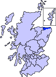
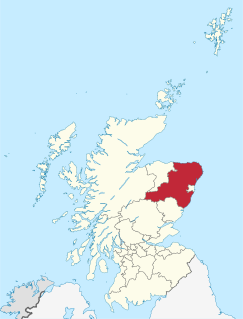
Banff and Buchan is a committee area of the Aberdeenshire Council, Scotland. It has a population of 35,742. Fishing and agriculture are important industries, together with associated processing and service activity.

Aberdeenshire or the County of Aberdeen is a historic county and registration county of Scotland. The area of the county, excluding the city of Aberdeen itself, is also a lieutenancy area. The county borders Kincardineshire, Angus and Perthshire to the south, Inverness-shire and Banffshire to the west, and the North Sea to the north and east. It has a coast-line of 65 miles (105 km).

Kintore is a town and former royal burgh near Inverurie in Aberdeenshire, Scotland, now bypassed by the A96 road between Aberdeen and Inverness. It is situated on the banks of the River Don. The Town House dates from 1747.

Crathie is a village in Aberdeenshire, Scotland. It stands on the north bank of the River Dee.

Gardenstown is a small coastal village, 8.7 miles (14.0 km) by road east of Banff in Aberdeenshire, northeastern Scotland.
Torphins is a village in Royal Deeside, Aberdeenshire, Scotland which lies about 22 miles (35 km) west of Aberdeen. It is situated on the A980, about 7 miles (11 km) north-west of Banchory, and was once served by the Great North of Scotland Railway.
Vitrified forts are stone enclosures whose walls have been subjected to vitrification through heat. It was long thought that these structures were unique to Scotland, but they have since been identified in several other parts of western and northern Europe.

Strichen is a village in Aberdeenshire, Scotland. It sits on the A981, connecting it to New Deer 7.2 miles (12 km) to the southwest and Fraserburgh 8 miles (13 km) to the north-northeast, and the B9093, connecting it to New Pitsligo about 4 miles (6.4 km) due west. The village got its name from Lord Strachen. It is situated on the River Ugie at the foothills of Mormond Hill. The Strichen White Horse is constructed of quartz on Mormond Hill, some 1,500 m (1,600 yd) northeast of Strichen.

Strichen stone circle is a Megalithic recumbent stone circle located near Strichen, Aberdeenshire in the north east of Scotland. It has been destroyed twice and in the early 1980s was excavated and reconstructed.

New Pitsligo, also known as Cavoch, is a village in Aberdeenshire, Scotland, quite near Peterhead.

Strachan is a village in Aberdeenshire, Scotland that lies along the Water of Feugh, a tributary of the River Dee, Aberdeenshire, a few miles southwest of Banchory.

Banff Bay is a coastal embayment in Scotland situated between the towns of Banff, Aberdeenshire and Macduff, Aberdeenshire. The Burn of Myrehouse is one of the streams draining to Banff Bay. Banff Bay is a prominent geographical feature along the northern coast of Aberdeenshire, and it is visible from a number of locations along the coastal plain such as Longman Hill situated somewhat distant to the east.

Clan Craig is a Scottish clan hailing from Aberdeenshire. The clan does not have a chief recognized by the Lord Lyon King of Arms, therefore the clan has no standing under Scots Law. Clan Craig is considered an armigerous clan, meaning that it is considered to have had at one time a chief who possessed the chiefly arms, however no one at present is in possession of such arms.

New Leeds is a planned village in the Buchan area of Aberdeenshire, Scotland, situated 5.1 kilometres (3.2 mi) east of Strichen at the foot of Mormond Hill.

Sunhoney is a stone circle of the recumbent type, which is common in the Grampian region, in particular at the River Dee. Sunhoney is situated about 2 km west of Echt in Aberdeenshire, near to the Cullerlie and Midamr stone circles. It is designated a scheduled ancient monument

Clan Russell is a Scottish armigerous clan, with claimed origins in Normandy. It has ancestral ties to the English Dukes of Bedford, and has numerous descendants in Great Britain and America.
| | This article related to Aberdeenshire, Scotland, is a stub. You can help Wikipedia by expanding it. |