
Etne is a municipality in Hordaland county, Norway. It is located in the traditional district of Sunnhordland, although it is also sometimes considered to be part of the district of Haugaland. The administrative centre of the municipality is the village of Etnesjøen. Other villages in the municipality include Skånevik and Fjæra. The two largest villages in the municipality are Etnesjøen with 1,159 residents and Skånevik with 594 residents.

Jondal is a municipality in Hordaland county, Norway. It is located on the Folgefonna peninsula in the Hardanger district, on the eastern shore of the Hardangerfjorden. The administrative centre of the municipality is the village of Jondal. Other villages in Jondal include Herand, Kysnesstranda, and Torsnes.
Sunnhordland is a traditional district in the Vestlandet region of Norway. The district consists of the southern coastal regions of Hordaland county. In includes the areas that surround the mouth of the Hardangerfjorden and the surrounding islands. The municipalities of Sveio, Etne, Stord, Bømlo, Fitjar, Kvinnherad, and Tysnes make up the district of Sunnhordaland. The regional centre of this district is the town of Leirvik in Stord.

Rosendal is the administrative centre of the municipality of Kvinnherad in Hordaland county, Norway. The village is located on the southern shore of the Hardangerfjorden, about 4 kilometres (2.5 mi) north of the village of Dimmelsvik and about 10 kilometres (6.2 mi) straight west of the vast Folgefonna glacier which sits inside the nearby Folgefonna National Park. The village is especially known for the Barony Rosendal, a historic estate located in the village. Kvinnherad Church is also located in this village.

Varaldsøy is an island in the municipality of Kvinnherad in Hordaland county, Norway. The 45.4-square-kilometre (17.5 sq mi) island is the largest island in the Hardangerfjorden. Most of the inhabitants live on the southern tip of the island in the village of Varaldsøy, where Varaldsøy Church is located. The 600-metre (2,000 ft) tall mountain Øyefjellet is the highest point on the island.
Blådalsvatnet is a glacial lake in the municipality of Kvinnherad in Hordaland county, Norway. The 2.89-square-kilometre (1.12 sq mi) lake lies just outside the Folgefonna National Park, about 10 kilometres (6.2 mi) north of the village of Indre Matre. The lake is formed by the glacial runoff from the large Folgefonna glacier located just north of the lake. The lake is part of the water system used to power the Blåfalli kraftverk hydroelectric power station.
Juklavatnet is a lake on the border of the municipalities of Kvinnherad and Jondal in Hordaland county, Norway. The 3.61-square-kilometre (1.39 sq mi) lake lies just outside Folgefonna National Park and immediately to the west of the Nordre Folgefonna glacier. The only road access comes from the small village of Nordrepollen in the Mauranger area of Kvinnherad municipality, about 10 kilometres (6.2 mi) south of the lake. There is a dam on the western end of the lake which regulates the depth of the water so that it can be used for hydroelectric power generation. The lake is the largest reservoir that feeds into the Mauranger power station.
Onarheimsvatnet or Opsangervatnet is a lake in the municipality of Kvinnherad in Hordaland county, Norway. The 2.25-square-kilometre (0.87 sq mi) lake is located between the villages of Husnes and Sunde.

Fjelberg is a former municipality in Hordaland county, Norway. The municipality existed from 1838 until 1965 when it was dissolved. In 1965, the municipality covered 79.8 square kilometres (30.8 sq mi), mostly islands and a small area on the mainland. It encompassed part of the present day municipalities of Kvinnherad and Vindafjord, primarily the islands of Fjelbergøya, Borgundøya, and Halsnøya, as well as some surrounding areas on the mainland. The administrative centre of the municipality was the small village located on the island of Fjelbergøya where Fjelberg Church is located.

Husnes is the largest village in Kvinnherad municipality in Hordaland county, Norway. The village is located on the southern shore of the Hardangerfjorden on the Folgefonna peninsula, about 8 kilometres (5.0 mi) south of the village of Herøysund and immediately north of the villages of Sunde and Valen. The lake Onarheimsvatnet lies along the southwestern part of the village between Husnes and Sunde.

Valen is a village in Kvinnherad municipality in Hordaland county, Norway. The village is located on the mainland coast overlooking the island of Halsnøy to the south. The undersea Halsnøy Tunnel connects Halsnøy island to the mainland just to the west of Valen, in the neighboring village of Sunde.
Uskedal or Uskedalen is a village in Kvinnherad municipality in Hordaland county, Norway. The village is located in a small valley along the southern shore of the Hardangerfjorden, about 7 kilometres (4.3 mi) southwest of the village of Dimmelsvik and about 4 kilometres (2.5 mi) east of the village of Herøysund.

Hatlestrand is a village in Kvinnherad municipality in Hordaland county, Norway. The village is located along the Hardangerfjorden, northeast of the villages of Husa and Ølve. The village has a ferry port called Gjermundshamn, which has regular ferry connections to the island of Varaldsøy and to Årsnes on the opposite side of the fjord. Hatlestrand Church is located in the village.
Varaldsøy is a former municipality in Hordaland county, Norway. The 83-square-kilometre (32 sq mi) municipality encompassed the whole island of Varaldsøy and a 2-to-3-kilometre wide strip of the mainland northwest and west of the island. The administrative centre of the municipality was the village area of Varaldsøy on the southern part of the island, where Varaldsøy Church is located.
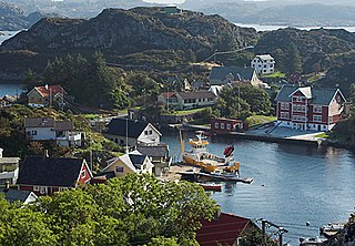
Skånevik is a village in Etne municipality in Hordaland county, Norway. The village is located along the Skånevikfjorden, near the entrance to the Åkrafjorden. The village lies across the fjord from the village of Utåker in neighboring Kvinnherad municipality. The municipal centre of Etnesjøen lies about 8 kilometres (5.0 mi) straight south across a mountain, although one must drive about 22 kilometres (14 mi) around the mountain to get there.

Sæbøvik is a village in Kvinnherad municipality in Hordaland county, Norway. The village is located on the narrow, western part of the island of Halsnøya, about 6 kilometres (3.7 mi) west of the village of Høylandsbygd and immediately east of the village of Eidsvik. The village is located at the southern end of the Halsnøy Tunnel.
Eidsvik is a village in Kvinnherad municipality in Hordaland county, Norway. The village is located on the northwestern end of the island of Halsnøya, just west of the village of Sæbøvik. The village lies on a thin, narrow isthmus-like peninsula sticking out into the Hardangerfjorden.
Sunde is a village in Kvinnherad municipality in Hordaland county, Norway. The village is located along the Hardangerfjorden, just north of the island of Halsnøya. The northern entrance to the Halsnøy Tunnel is located in Sunde. The large urban village of Husnes lies just to the north of Sunde, on the other end of the lake Onarheimsvatnet.
Dimmelsvik is a village in Kvinnherad municipality in Hordaland county, Norway. The village is located on the south shore of the Hardangerfjorden, about 4 kilometres (2.5 mi) south of the municipal centre of Rosendal and about 7 kilometres (4.3 mi) northeast of the village of Uskedal.


