The area lies centrally within the Oldenburg-East Frisian geest ridge. Already in prehistoric and early historic times Hesel was the junction of a road network. It still has this function today in the modern road network of East Frisia. On the territory of the joint municipality there are many of the oldest traces of human settlement of East Frisia. Favoured by its location, the main village of Hesel was the site of two monasteries and several monastery outworks in the High and Late Middle Ages. On January 17, 1972, the six communities mentioned above merged to form the joint municipality of Hesel.
Economically, the joint municipality of Hesel is primarily characterized by medium-sized businesses. Agriculture has always played a major role in the joint municipality, as can be seen from the high proportion of agricultural land of more than 75 percent. Tourism plays a role to a certain extent. However, the joint municipality as a whole is a commuter area, especially to the neighboring county seat of Leer.
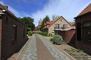
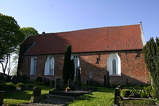
The cultural heritage of the joint municipality includes the 13th century Marienkirche (St. Mary's Church) in Holtland, the former monastery outworks Gut Stikelkamp from the 16th century and several archaeological sites.
Frisia is a cross-border cultural region in Northwestern Europe. Stretching along the Wadden Sea, it encompasses the north of the Netherlands and parts of northwestern Germany. Wider definitions of ‘Frisia’ may include the island of Rem and the other Danish Wadden Sea Islands. The region is traditionally inhabited by the Frisians, a West Germanic ethnic group.
Leer is a district (Landkreis) in Lower Saxony, Germany. It is bounded by the city of Emden, the districts of Aurich, Wittmund, Friesland, Ammerland, Cloppenburg and Emsland, and by the Netherlands.
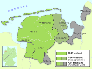
East Frisia or East Friesland is a historic region in the northwest of Lower Saxony, Germany. It is primarily located on the western half of the East Frisian peninsula, to the east of West Frisia and to the west of Landkreis Friesland.
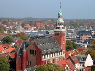
Leer is a town in the district of Leer, in the northwestern part of Lower Saxony, Germany. It is situated on the river Leda, a tributary of the river Ems, near the border with the Netherlands. With 34,958 inhabitants (2021), it is the third-largest city in East Frisia after Emden and Aurich.
Wittmund is a town and capital of the district of Wittmund, in Lower Saxony, Germany.
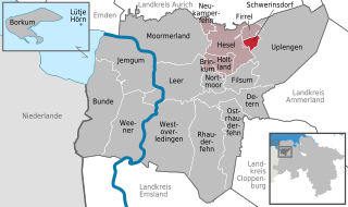
Hesel is a municipality in Leer district. It is situated approximately 12 km (7.5 mi) northeast of Leer, and 25 km (16 mi) east of Emden.
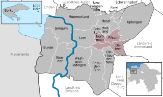
Jümme is a collective municipality (Samtgemeinde) in the district of Leer in the German state of Lower Saxony. It is named after the River Jümme which flows through all three constituent communities. It has an area of 82.34 km2 and a population of 6,421. It is situated in the region of East Frisia. Along with the Samtgemeinde of Hesel, it is one of two in the district. It was formed in the wake of local government reform in 1973. Filsum serves as the administrative centre.
Altes Land is an area of reclaimed marshland straddling parts of Lower Saxony and Hamburg. The region is situated downstream from Hamburg on the southwestern riverside of the Elbe around the towns of Stade, Buxtehude, Jork and the Samtgemeinde of Lühe. In Hamburg it includes the quarters of Neuenfelde, Cranz, Francop and Finkenwerder. Altes Land is one of the Elbe Marshes.
Lamspringe is a village and a municipality in the district of Hildesheim, in Lower Saxony, Germany. It is situated approximately 20 km south of Hildesheim. Since 1 November 2016, the former municipalities Harbarnsen, Neuhof, Sehlem and Woltershausen are part of the municipality Lamspringe. Glashütte is a district of the Lamspringe community and located around 4 km east of Lamspringe on the L 466 state road to Rhüden in the Schlörbach valley. In the 18th century, the Lamspringe monastery founded a forest glassworks. It was located in the extensive wooded area of the Westerhof monastery forest, which borders the Heber ridge. In 1792 Johann Friedrich Stender from Ziegenhagen resumed glass production in the monastery forest and founded a glassworks with the Stender glass factory. The Glashütte settlement, for which the company was named, emerged from it.
Bunde is a municipal district in East Frisia, in Lower Saxony, Germany, about 20 km (12 mi) south of Emden, Germany, and 50 km (30 mi) east of Groningen, Netherlands. It lies on the southern tip of the Dollart, a bay of the North Sea between Germany and the Netherlands, and has a land border with the Netherlands.
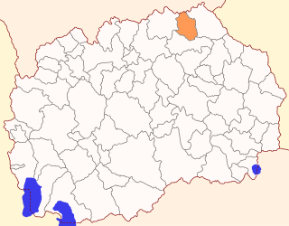
Rankovce is a municipality in the northeastern region of the Republic of North Macedonia. Rankovce is also the name of the town where the municipal seat is found. Rankovce Municipality is part of the Northeastern statistical region.
Samtgemeinde Hankensbüttel is a Samtgemeinde in the district of Gifhorn, in Lower Saxony, Germany. It is situated approximately 30 km north-east of Gifhorn and 20 km south of Uelzen. 9.739 citizens are living in the Samtgemeinde Hankensbüttel.
Asbach is an Ortsgemeinde – a municipality belonging to a Verbandsgemeinde, a kind of collective municipality – in the Birkenfeld district in Rhineland-Palatinate, Germany. It belongs to the Verbandsgemeinde Herrstein-Rhaunen, whose seat is in Herrstein.
Ohne is a community in the district of Grafschaft Bentheim in Lower Saxony, Germany.
Schwerinsdorf is a municipality in the district of Leer, in Lower Saxony, Germany. The municipality has 705 inhabitants and covers an area of 5.57 square kilometers.
Krottelbach is an Ortsgemeinde – a municipality belonging to a Verbandsgemeinde, a kind of collective municipality – in the Kusel district in Rhineland-Palatinate, Germany. It belongs to the Verbandsgemeinde of Oberes Glantal.
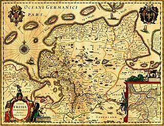
The history of East Frisia developed rather independently from the rest of Germany because the region was relatively isolated for centuries by large stretches of bog to the south, while at the same time its people were oriented towards the sea. Thus in East Frisia in the Middle Ages there was little feudalism, instead a system of fellowship under the so-called Friesian Freedom emerged. It was not until 1464, that the House of Cirksena was enfeoffed with the Imperial County of East Frisia. Nevertheless absolutism had been, and continued to be, unknown in East Frisia. In the two centuries after about 1500, the influence of the Netherlands is discernable - politically, economically and culturally. In 1744, the county lost its independence within the Holy Roman Empire and became part of Prussia. Following the Vienna Congress of 1815, it was transferred to the Kingdom of Hanover, in 1866 it went back to Prussia and, from 1946, it has been part of the German state of Lower Saxony.
East Frisia is a collective term for all traditionally Frisian areas in Lower Saxony, Germany, which are primarily located on a peninsula between the Dollart and the Jade Bight. Along with West Frisia and North Frisia, it is one of the most commonly used subdivisions of Frisia.
Visquard is a village in the region of East Frisia, in Lower Saxony, Germany. It is part of the municipality of Krummhörn. The village is located to the north of Pewsum and to the south of Greetsiel.
Tergast is a village in the region of East Frisia, in Lower Saxony, Germany. Administratively, it is an Ortsteil of the municipality of Moormerland. Tergast is 1.5 kilometers to the northeast of Oldersum and has a population of 457.
This page is based on this Wikipedia article Text is available under the CC BY-SA 4.0 license; additional terms may apply. Images, videos and audio are available under their respective licenses.