
Wittmund is a Landkreis (district) in the northwestern part of Lower Saxony, Germany. It is situated in East Frisia, on the North Sea coast. Neighboring districts are Friesland, Leer and Aurich.

East Frisia or East Friesland is a historic region in the northwest of Lower Saxony, Germany. It is primarily located on the western half of the East Frisian peninsula, to the east of West Frisia and to the west of Landkreis Friesland.
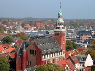
Leer is a town in the district of Leer, in the northwestern part of Lower Saxony, Germany. It is situated on the river Leda, a tributary of the river Ems, near the border with the Netherlands. With 34,958 inhabitants (2021), it is the third-largest city in East Frisia after Emden and Aurich.

Aurich is a town in the East Frisian region of Lower Saxony, Germany. It is the capital of the district of Aurich and is the second largest City in East Frisia, both in population, after Emden, and in area, after Wittmund.

The Kingdom of Hanover was established in October 1814 by the Congress of Vienna, with the restoration of George III to his Hanoverian territories after the Napoleonic era. It succeeded the former Electorate of Hanover, and joined 38 other sovereign states in the German Confederation in June 1815. The kingdom was ruled by the House of Hanover, a cadet branch of the House of Welf, in personal union with Great Britain between 1714 and 1837. Since its monarch resided in London, a viceroy, usually a younger member of the British royal family, handled the administration of the Kingdom of Hanover.

Wittmund is a town and capital of the district of Wittmund, in Lower Saxony, Germany.

Amt Neuhaus is a municipality in the District of Lüneburg, in Lower Saxony, Germany. Amt means "municipal office" in German. The original "municipal office of Neuhaus" existed since at least the 17th century until 1885, consecutively as part of Saxe-Lauenburg, Electorate of Hanover (1689-1810), Kingdom of Hanover (1814-1866), and the Prussian Province of Hanover (1866-1885).
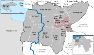
Jümme is a collective municipality (Samtgemeinde) in the district of Leer in the German state of Lower Saxony. It is named after the River Jümme which flows through all three constituent communities. It has an area of 82.34 km2 and a population of 6,421. It is situated in the region of East Frisia. Along with the Samtgemeinde of Hesel, it is one of two in the district. It was formed in the wake of local government reform in 1973. Filsum serves as the administrative centre.

Elchingen is a municipality about 7 km east of Ulm–Neu-Ulm in the district of Neu-Ulm in Bavaria, Germany.

The Province of Hanover was a province of the Kingdom of Prussia and the Free State of Prussia from 1866 to 1946.

Garbsen is a town in the district of Hanover, in Lower Saxony, Germany. It is situated on the river Leine, approx. 11 km northwest of Hanover. The name Garbsen can be traced back to 1223. Today's 13 city districts have partly developed independently until the city of Garbsen was formed within its current boundaries during the regional reform in 1974.

Rodenberg is a town in the district of Schaumburg, in Lower Saxony, Germany. It is situated on the northwestern edge of the Deister hills, approx. 10 km east of Stadthagen, and 27 km west of Hanover.

The Rheiderland is a region of Germany and the Netherlands between the River Ems and the Bay of Dollart. The German part of the Rheiderland lies in East Frisia, west of the Ems. The Dutch part lies in the Dutch province of Groningen and is mostly part of Oldambt. The Rheiderland is one of the four historic regions on the mainland in the district of Leer; the others being the Overledingerland, the Moormerland and the Lengenerland.
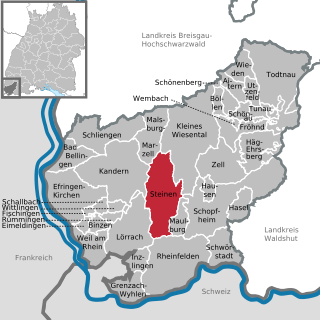
Steinen is a municipality in the district of Lörrach in the southwest of Baden-Württemberg, Germany. It is situated on the river Wiese, 15 km northeast of Basel, and 6 km northeast of Lörrach.

The Evangelical-Lutheran Church of Hanover is a Lutheran church body (Landeskirche) in the northern German state of Lower Saxony and the city of Bremerhaven covering the territory of the former Kingdom of Hanover.

Baienfurt is an Upper Swabian municipality in the district of Ravensburg in Baden-Württemberg, Germany. The municipality, with a population of over 7,000 inhabitants, is part of the Middle Schussental Municipal Administration Association.

Pfronten is a municipality in the district of Ostallgäu in Bavaria in Germany.

Düdenbüttel is a municipality in the district of Stade, Lower Saxony, Germany.

Hesel is a Samtgemeinde in the district of Leer, in Lower Saxony, Germany. Its seat is in the village Hesel.
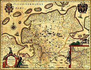
The history of East Frisia developed rather independently from the rest of Germany because the region was relatively isolated for centuries by large stretches of bog to the south, while at the same time its people were oriented towards the sea. Thus in East Frisia in the Middle Ages there was little feudalism, instead a system of fellowship under the so-called Friesian Freedom emerged. It was not until 1464, that the House of Cirksena was enfeoffed with the Imperial County of East Frisia. Nevertheless absolutism had been, and continued to be, unknown in East Frisia. In the two centuries after about 1500, the influence of the Netherlands is discernable - politically, economically and culturally. In 1744, the county lost its independence within the Holy Roman Empire and became part of Prussia. Following the Vienna Congress of 1815, it was transferred to the Kingdom of Hanover, in 1866 it went back to Prussia and, from 1946, it has been part of the German state of Lower Saxony.


