Moormerland

Last updated
Moormerland
Wappen Moormerland.svg
Location of Moormerland within Leer district
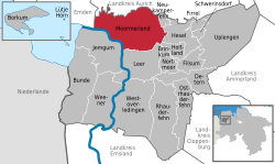
Moormerland in LER.svgBundeLeerLeer (Borkum)
Germany adm location map.svg
Red pog.svg
Moormerland
Lower Saxony location map.svg
Red pog.svg
Moormerland
Coordinates: 53°19′11″N7°25′22″E / 53.31972°N 7.42278°E / 53.31972; 7.42278
Country Germany
State Lower Saxony
District Leer
Government
   Mayor (202126) Hendrik Schulz [1] (SPD)
Area
  Total122 km2 (47 sq mi)
Elevation
1 m (3 ft)
Population
 (2021-12-31) [2]
  Total23,987
  Density200/km2 (510/sq mi)
Time zone UTC+01:00 (CET)
  Summer (DST) UTC+02:00 (CEST)
Postal codes
26802
Dialling codes 04954, 04945, 04924
Vehicle registration LER
Website moormerland.conne.net

Moormerland is a municipality in the Leer District, in Lower Saxony, northwestern Germany.

History

Moormerland was created on January 1st, 1973 by uniting eleven independent municipalities. [3] The eleven constituent Ortschafte are:

VillagePopulation (2016)
Boekzetelerfehn 748
Gandersum 85
Hatshausen 602
Jheringsfehn 2,440
Neermoor 4,748
Oldersum 1,533
Rorichum 444
Terborg 105
Tergast 457
Veenhusen 4,157
Warsingsfehn 7,951
Total23,270

Related Research Articles

<span class="mw-page-title-main">Jemgum</span> Municipality in Lower Saxony, Germany

Jemgum is a municipality in the Leer district, in the northwest of Lower Saxony, Germany. The area is known as Rheiderland (German) or Reiderland (Dutch). Rheiderland is located in East Friesland.

<span class="mw-page-title-main">Walkenried</span> Municipality in Lower Saxony, Germany

Walkenried is a municipality in the district of Göttingen, in Lower Saxony, Germany. It is situated in the southern Harz, approx. 15 km south of Braunlage, and 15 km northwest of Nordhausen.

<span class="mw-page-title-main">Bissendorf</span> Municipality in Lower Saxony, Germany

Bissendorf is a municipality in the district of Osnabrück, in Lower Saxony, Germany. It is situated approximately 9 km southeast of Osnabrück. Population 14,700 (2020).

<span class="mw-page-title-main">Geeste, Emsland</span> Municipality in Lower Saxony, Germany

Geeste is a municipality in the district Emsland in Lower Saxony.

<span class="mw-page-title-main">Großheide</span> Municipality in Lower Saxony, Germany

Großheide is a village and a municipality in the district of Aurich, in Lower Saxony, Germany. It is situated approximately 10 km east of Norden, and 15 km northwest of Aurich.

<span class="mw-page-title-main">Ihlow</span> Municipality in Lower Saxony, Germany

Ihlow is a village and a municipality in the district of Aurich, in Lower Saxony, Germany. It is situated approximately 8 km southwest of Aurich, and 15 km east of Emden.

<span class="mw-page-title-main">Krummhörn</span> Municipality in Lower Saxony, Germany

Krummhörn is a municipality in the district of Aurich, in Lower Saxony, Germany. It is situated near the Ems estuary, approximately 15 km southwest of Norden, and 10 km northwest of Emden.

<span class="mw-page-title-main">Südbrookmerland</span> Municipality in Lower Saxony, Germany

Südbrookmerland is a municipality in the district of Aurich, in Lower Saxony, Germany. It is situated approximately 7 km west of Aurich. Its seat is in the village Victorbur.

<span class="mw-page-title-main">Wagenfeld</span> Municipality in Lower Saxony, Germany

Wagenfeld is a municipality in the district of Diepholz, Lower Saxony, Germany. It is situated approximately 15 km east of Diepholz, and 40 km northwest of Minden.

<span class="mw-page-title-main">Emsbüren</span> Municipality in Lower Saxony, Germany

Emsbüren is a municipality in the Emsland district, Lower Saxony, Germany. It is situated on the river Ems, approx. 15 km south of Lingen, and 15 km northwest of Rheine.

<span class="mw-page-title-main">Rhede, Lower Saxony</span> Municipality in Lower Saxony, Germany

Rhede is a municipality in the Emsland district, Lower Saxony, Germany. It is situated on the river Ems, near the border with the Netherlands, approx. 10 km west of Papenburg, and 20 km southeast of Winschoten.

<span class="mw-page-title-main">Wangerland</span> Municipality in Lower Saxony, Germany

Wangerland is a municipality in the district of Friesland, Lower Saxony, Germany. It is situated on the North Sea coast, approximately 20 km northwest of Wilhelmshaven, and 10 km north of Jever. Its seat is in the village Hohenkirchen.

<span class="mw-page-title-main">Sassenburg</span> Municipality in Lower Saxony, Germany

Sassenburg is a municipality in the district of Gifhorn, Lower Saxony, Germany. It is situated approximately 7 km northeast of Gifhorn, and 15 km northwest of Wolfsburg. Sassenburg includes the villages of Dannenbüttel, Grußendorf, Neudorf-Platendorf, Stüde, Triangel and Westerbeck. The seat of the municipality is in the village Westerbeck.

<span class="mw-page-title-main">Staufenberg, Lower Saxony</span> Municipality in Lower Saxony, Germany

Staufenberg is the southernmost municipality of the district of Göttingen, and of Lower Saxony, Germany. It is situated east of the river Fulda, approx. 6 km south of Hannoversch Münden, and 12 km northeast of Kassel. Its seat is in the village Landwehrhagen.

<span class="mw-page-title-main">Holle</span> Municipality in Lower Saxony, Germany

Holle is a village and a municipality in the district of Hildesheim, in Lower Saxony, Germany. It is situated approximately 15 km southeast of Hildesheim, and 15 km west of Salzgitter. It was mentioned in Tom Clancy's bestseller Red Storm Rising.

<span class="mw-page-title-main">Steyerberg</span> Municipality in Lower Saxony, Germany

Steyerberg is a municipality in the district of Nienburg, in Lower Saxony, Germany. It is situated approximately 15 km southwest of Nienburg, and 30 km north of Minden.

<span class="mw-page-title-main">Bad Rothenfelde</span> Municipality in Lower Saxony, Germany

Bad Rothenfelde is a municipality and health resort in the district of Osnabrück, in Lower Saxony, Germany.

<span class="mw-page-title-main">Hagen, Osnabrück</span> Municipality in Lower Saxony, Germany

Hagen is a municipality in the district of Osnabrück, in Lower Saxony, Germany. It is situated in the Teutoburg Forest, approx. 10 km southwest of Osnabrück.

<span class="mw-page-title-main">Hasbergen</span> Municipality in Lower Saxony, Germany

Hasbergen is a municipality in the district of Osnabrück, in Lower Saxony, Germany. It is situated in the Teutoburg Forest, approx. 7 km west of Osnabrück. Hasbergen consists of Hasbergen proper, Gaste and Ohrbeck.

<span class="mw-page-title-main">Wurster Nordseeküste</span> Municipality in Lower Saxony, Germany

Wurster Nordseeküste is a municipality in the district of Cuxhaven, in Lower Saxony, Germany. It takes its name from the historic region Land Wursten and the North Sea coast. It was formed on 1 January 2015 by the merger of the former municipalities Nordholz, Cappel, Dorum, Midlum, Misselwarden, Mulsum, Padingbüttel and Wremen.

References

  1. "Stichwahlen zu Direktwahlen in Niedersachsen vom 26. September 2021" (PDF). Landesamt für Statistik Niedersachsen. 13 October 2021.
  2. "LSN-Online Regionaldatenbank, Tabelle A100001G: Fortschreibung des Bevölkerungsstandes, Stand 31. Dezember 2021" (in German). Landesamt für Statistik Niedersachsen.
  3. "Geschichte // Gemeinde Moormerland". www.moormerland.de. Retrieved 2024-03-08.