The Battle of Vimy Ridge was part of the Battle of Arras, in the Pas-de-Calais department of France, during the First World War. The main combatants were the four divisions of the Canadian Corps in the First Army, against three divisions of the German 6th Army. The battle took place from 9 to 12 April 1917 at the beginning of the Battle of Arras, the first attack of the Nivelle Offensive, which was intended to attract German reserves from the French, before the French attempt at a decisive offensive on the Aisne and the Chemin des Dames ridge further south, several days later.

Burr Ridge is a village in Cook and DuPage counties in the U.S. state of Illinois. Per the 2020 census, the population was 11,192.
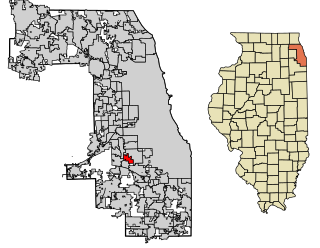
Chicago Ridge is a village in Cook County, Illinois, United States. Per the 2020 census, the population was 14,433.

Mellieħa is a large village in the Northern Region of Malta. It has a population of 10,087 as of March 2014. Mellieħa is also a tourist resort, popular for its sandy beaches, natural environment, and Popeye Village nearby.
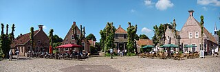
Bourtange is a village with a population of 430 in the municipality of Westerwolde in the Netherlands. It is situated in the region Westerwolde in the east of the province of Groningen near the German border. Fort Bourtange was built in 1593 during the Dutch Revolt and was used until 1851. Between 1967 and 1992 the star fort was gradually restored to its mid-18th-century state and it is currently an open-air museum.

The Shawangunk Ridge, also known as the Shawangunk Mountains or The Gunks, is a ridge of bedrock in Ulster County, Sullivan County and Orange County in the state of New York, extending from the northernmost point of the border with New Jersey to the Catskills. The Shawangunk Ridge is a continuation of the long, easternmost section of the Appalachian Mountains; the ridge is known as Kittatinny Mountain in New Jersey, and as Blue Mountain as it continues through Pennsylvania. This ridge constitutes the western border of the Great Appalachian Valley.

Hawthorn Ridge Redoubt was a German field fortification, west of the village of Beaumont Hamel on the Somme. The redoubt was built after the end of the Battle of Albert and as French and later British attacks on the Western Front became more formidable, the Germans added fortifications and trench positions near the original lines around Hawthorn Ridge. At 7:20 a.m. on 1 July 1916, the British fired a huge mine beneath the Hawthorn Ridge Redoubt. Sprung ten minutes before zero hour, the mine was one of 19 mines detonated on the first day of the Battle of the Somme. Geoffrey Malins, one of two official war cameramen, filmed the detonation of the mine. The attack on the redoubt by part of the 29th Division of VIII Corps was a costly failure.

The Battle of Pozières took place in northern France around the village of Pozières, during the Battle of the Somme. The costly fighting ended with the British in possession of the plateau north and east of the village, in a position to menace the German bastion of Thiepval from the rear. The Australian official historian Charles Bean wrote that Pozières ridge "is more densely sown with Australian sacrifice than any other place on earth".
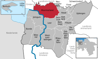
Moormerland is a municipality in the Leer District, in Lower Saxony, northwestern Germany.

Notre Dame de Lorette, also known as Ablain St.-Nazaire French Military Cemetery, is the world's largest French military cemetery. It is the name of a ridge, basilica, and French national cemetery northwest of Arras at the village of Ablain-Saint-Nazaire. The high point of the hump-backed ridge stands 165 metres high and – with Vimy Ridge – utterly dominates the otherwise flat Douai plain and the town of Arras.
Gasselternijveen is a village in the Dutch province of Drenthe. It is a part of the municipality of Aa en Hunze, and lies about 20 km east of Assen.

The Battle of Aubers was a British offensive on the Western Front on 9 May 1915 during the First World War. The battle was part of the British contribution to the Second Battle of Artois, a Franco-British offensive intended to exploit the German diversion of troops to the Eastern Front. The French Tenth Army was to attack the German 6th Army north of Arras and capture Vimy Ridge, preparatory to an advance on Cambrai and Douai. The British First Army, on the left (northern) flank of the Tenth Army, was to attack on the same day and widen the gap in the German defences expected to be made by the Tenth Army and to fix German troops north of La Bassée Canal.

Neuville-Saint-Vaast is a commune in the Pas-de-Calais department in the Hauts-de-France region of France. It is located 3.2 kilometres (2.0 mi) south of the Canadian National Vimy Memorial dedicated to the Battle of Vimy Ridge. The Memorial was built on Hill 145, the highest point of the ridge to commemorate the battle and the Canadian soldiers who lost their lives during the First World War. The Memorial is also the site of the Canadian Cemetery No. 2, Neuville-St.-Vaast and Givenchy Road Canadian Cemetery, Neuville-St.-Vaast.
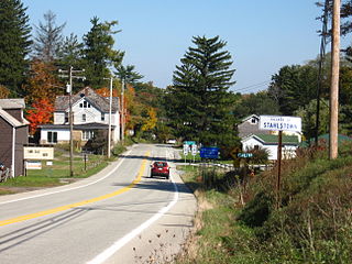
Stahlstown is a small unincorporated community that is located in Cook Township, Westmoreland County, Pennsylvania, United States. It is situated fifty miles south of Pittsburgh, just a few miles from the Donegal exit on the Pennsylvania Turnpike, at the intersection of route 711 and route 130.

Hettenrodt is an Ortsgemeinde – a municipality belonging to a Verbandsgemeinde, a kind of collective municipality – in the Birkenfeld district in Rhineland-Palatinate, Germany. It belongs to the Verbandsgemeinde Herrstein-Rhaunen, whose seat is in Herrstein.

Rašica is a small village in the hills above Srednje Gameljne north of the capital Ljubljana in central Slovenia. It belongs to the City Municipality of Ljubljana. It is part of the traditional region of Upper Carniola and is now included with the rest of the municipality in the Central Slovenia Statistical Region.
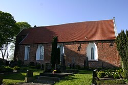
Groothusen is an old Langwurtendorf – a village on an artificially-built ridge – in the municipality of Krummhörn in western East Frisia on Germany's North Sea coast. It lies about 15 kilometres northwest of the seaport of Emden and has a population of 474 (2006). The ridge or warf has a length of about 500 metres and a width of some 130 metres and was built to raise the village above the water level should flooding from the sea occur, for instance, during a storm tide.

Leer (Ostfriesland) (German pronunciation:[leːɐ̯ʔɔstfʁiːslant]) is a railway station in the town of Leer in Lower Saxony, Germany. The railway station is situated on the Emsland Railway between the railway stations of Emden and Papenburg and it is the railway terminus on the Oldenburg–Leer railway after the railway station of Augustfehn. The train services are operated by Deutsche Bahn, WestfalenBahn and Arriva (a subsidiary of Deutsche Bahn).
Veenhusen is a village in the municipality of Moormerland in Leer District, Lower Saxony, northwestern Germany.

Rorichum is a village in the region of East Frisia, in Lower Saxony, Germany. Administratively, it is an Ortsteil of the municipality of Moormerland. Located on the north bank of the Ems estuary, Rorichum is just to the southeast of Oldersum. It has a population of 444.