
Sopot is a seaside resort city in Pomerelia on the southern coast of the Baltic Sea in northern Poland, with a population of approximately 40,000. It is located in Pomerania Province and has the status of county – the smallest city in Poland to have that status. Sopot lies between the larger cities of Gdańsk to the southeast and Gdynia to the northwest. The three cities together form the Tricity metropolitan area.
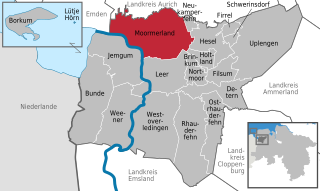
Moormerland is a municipality in the Leer District, in Lower Saxony, northwestern Germany.
Jümme is a collective municipality (Samtgemeinde) in the district of Leer in the German state of Lower Saxony. It is named after the River Jümme which flows through all three constituent communities. It has an area of 82.34 km2 and a population of 6,421. It is situated in the region of East Frisia. Along with the Samtgemeinde of Hesel, it is one of two in the district. It was formed in the wake of local government reform in 1973. Filsum serves as the administrative centre.

The Rheiderland is a region of Germany and the Netherlands between the River Ems and the Bay of Dollart. The German part of the Rheiderland lies in East Frisia, west of the Ems. The Dutch part lies in the Dutch province of Groningen and is mostly part of Oldambt. The Rheiderland is one of the four historic regions on the mainland in the district of Leer; the others being the Overledingerland, the Moormerland and the Lengenerland.
Johann Eekhoff was a German economist and former state secretary of the Federal Ministry of Economics and Technology. He held a chair for economic policy at the University of Cologne until 2009.

The Auricherland was an historic region, in central East Frisia, which covered a large area around the town of Aurich in north Germany.
The Emsigerland, or Emderland was a historic region on the western edge of East Frisia by the Wadden Sea, which covered a wide area around the town of Emden. The Emsigerland borders in the north on the Federgau, in the northeast on the Brokmerland in the east on the Moormerland and in the south on the Rheiderland.

Jheringsfehn is a peat village in the region of East Frisia, in Lower Saxony, Germany. Administratively, it is an Ortsteil of the municipality of Moormerland. Warsingsfehn is located just to the east of Warsingsfehn and is approximately 10 kilometers to the northeast of Leer. It has a population of 2,440.
Groothusen is an old Langwurtendorf – a village on an artificially-built ridge – in the municipality of Krummhörn in western East Frisia on Germany's North Sea coast. It lies about 15 kilometres northwest of the seaport of Emden and has a population of 474 (2006). The ridge or warf has a length of about 500 metres and a width of some 130 metres and was built to raise the village above the water level should flooding from the sea occur, for instance, during a storm tide.
Uko Fockena was an East Frisian chieftain of Moormerland and Emsigerland.

MikroKopter is a German company, a subsidiary of HiSystems GmbH, that manufactures battery-powered radio-controlled unmanned aerial vehicles. The company is located in Moormerland, Leer District, in Lower Saxony.

Leer (Ostfriesland) (German pronunciation:[leːɐ̯ʔɔstfʁiːslant]) is a railway station in the town of Leer in Lower Saxony, Germany. The railway station is situated on the Emsland Railway between the railway stations of Emden and Papenburg and it is the railway terminus on the Oldenburg–Leer railway after the railway station of Augustfehn. The train services are operated by Deutsche Bahn, WestfalenBahn and Arriva (a subsidiary of Deutsche Bahn).

Veenhusen is a village in the region of East Frisia, in Lower Saxony, Germany. Administratively, it is an Ortsteil of the municipality of Moormerland. Veenhusen is located just to the south of Warsingsfehn and is approximately 8 kilometers to the northeast of Leer. It has a population of 4,157.

Gandersum is a small village in the region of East Frisia, in Lower Saxony, Germany. Administratively, it is an Ortsteil of the municipality of Moormerland. Located on the north bank of the Ems estuary, Gandersum is to the southeast of Emden and the west of Oldersum. It has a population of 85.

Oldersum is a village in the region of East Frisia, in Lower Saxony, Germany. Administratively, it is an Ortsteil of the municipality of Moormerland. Located on the north bank of the Ems estuary, Oldersum is to the southeast of Emden and the northwest of Leer. It has a population of 1,533.
Tergast is a village in the region of East Frisia, in Lower Saxony, Germany. Administratively, it is an Ortsteil of the municipality of Moormerland. Tergast is 1.5 kilometers to the northeast of Oldersum and has a population of 457.

Terborg is a small village in the region of East Frisia, in Lower Saxony, Germany. Administratively, it is an Ortsteil of the municipality of Moormerland. Located on the north bank of the river Ems, Terborg is approximately 8 kilometers to the northwest of Leer. It has a population of 105.

Neermoor is a village in the region of East Frisia, in Lower Saxony, Germany. Administratively, it is an Ortsteil of the municipality of Moormerland. Located to the west of the river Ems, Neermoor is approximately 8 kilometers to the north of Leer. It has a population of 4,748.
Boekzetelerfehn is a village in the region of East Frisia, in Lower Saxony, Germany. Administratively, it is an Ortsteil of the municipality of Moormerland. Boekzetelerfehn is located just to the northeast of Warsingsfehn and is approximately 11 kilometers to the north of Leer. It has a population of 748.

Hatshausen is a village in the region of East Frisia, in Lower Saxony, Germany. Administratively, it is an Ortsteil of the municipality of Moormerland. Hatshausen is located to the northeast of Warsingsfehn and Boekzetelerfehn, and is approximately 13 kilometers to the northeast of Leer. It has a population of 602.


