East Frisia or East Friesland is a historic region in the northwest of Lower Saxony, Germany. It is primarily located on the western half of the East Frisian peninsula, to the east of West Frisia and to the west of Landkreis Friesland.
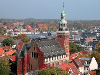
Leer is a town in the district of Leer, in the northwestern part of Lower Saxony, Germany. It is situated on the river Leda, a tributary of the river Ems, near the border with the Netherlands. With 34,958 inhabitants (2021), it is the third-largest city in East Frisia after Emden and Aurich.

Count John VII the Middle of Nassau-Siegen, German: Johann VII. der Mittlere Graf von Nassau-Siegen, official titles: Graf zu Nassau, Katzenelnbogen, Vianden und Diez, Herr zu Beilstein, was since 1606 Count of Nassau-Siegen, a part of the County of Nassau, and the progenitor of the House of Nassau-Siegen, a cadet branch of the Ottonian Line of the House of Nassau.
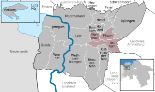
Jümme is a collective municipality (Samtgemeinde) in the district of Leer in the German state of Lower Saxony. It is named after the River Jümme which flows through all three constituent communities. It has an area of 82.34 km² and a population of 6,421. It is situated in the region of East Frisia. Along with the Samtgemeinde of Hesel, it is one of two in the district. It was formed in the wake of local government reform in 1973. Filsum serves as the administrative centre.

Logabirum is a quarter in the city of Leer in East Frisia, Lower Saxony, Germany.

Lahnstein is a verband-free town of Rhein-Lahn-Kreis in Rhineland-Palatinate, Germany. It is situated at the confluence of the Lahn with the Rhine, approximately 6 kilometres (3.7 mi) south of Koblenz. Lahnstein was created in 1969 by the merger of the previously independent towns of Oberlahnstein on the south side of the Lahn and Niederlahnstein on the north side. In 2020, it had a population of 18,030.

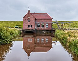
The Rheiderland is a region of Germany and the Netherlands between the River Ems and the Bay of Dollart. The German part of the Rheiderland lies in East Frisia, west of the Ems. The Dutch part lies in the Dutch province of Groningen and is mostly part of Oldambt. The Rheiderland is one of the four historic regions on the mainland in the district of Leer; the others being the Overledingerland, the Moormerland and the Lengenerland.

Argenschwang is an Ortsgemeinde – a municipality belonging to a Verbandsgemeinde, a kind of collective municipality – in the Bad Kreuznach district in Rhineland-Palatinate, Germany. It belongs to the Verbandsgemeinde of Rüdesheim, whose seat is in the municipality of Rüdesheim an der Nahe.
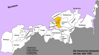
The Brokmerland is a landscape and an historic territory, located in western East Frisia, which covers the area in and around the present-day communities of Brookmerland and Südbrookmerland. The Brokmerland borders in the east on the Harlingerland and in the north on the Norderland. The historic Brokmerland is usually written with only one "o". Occasionally one also finds the spelling "Broekmerland", while today's communities have chosen to spell the name with a double "o".
Groothusen is an old Langwurtendorf – a village on an artificially-built ridge – in the municipality of Krummhörn in western East Frisia on Germany's North Sea coast. It lies about 15 kilometres northwest of the seaport of Emden and has a population of 474 (2006). The ridge or warf has a length of about 500 metres and a width of some 130 metres and was built to raise the village above the water level should flooding from the sea occur, for instance, during a storm tide.
Uko Fockena was an East Frisian chieftain of Moormerland and Emsigerland.

Count Henry of Nassau-Siegen, German: Heinrich Graf von Nassau-Siegen, official titles: Graf zu Nassau, Katzenelnbogen, Vianden und Diez, Herr zu Beilstein, was a count from the House of Nassau-Siegen, a cadet branch of the Ottonian Line of the House of Nassau. He served the Republic of the United Netherlands in diplomatic missions, as an officer in the Dutch States Army, and as governor of Hulst.

Duchess Margaret of Schleswig-Holstein-Sonderburg, German: Margarethe Herzogin von Schleswig-Holstein-Sonderburg, official titles: Erbin zu Norwegen, Herzogin zu Schleswig, Holstein, Stormarn und der Dithmarschen, Gräfin zu Oldenburg und Delmenhorst), was a duchess from the House of Schleswig-Holstein-Sonderburg and through marriage Countess of Nassau-Siegen.

Countess Mary Magdalene of Limburg-Stirum, Dutch: Maria Magdalena Gravin van Limburg-Stirum, official titles: gravin van Limburg en Bronkhorst, vrouwe van Stirum, Wisch en Borculo, erfbaandervrouw van het hertogdom Gelre en het graafschap Zutphen), was a countess from the House of Limburg-Stirum. In 1661 she succeeded her father as countess of Bronkhorst, lady of Wisch, Borculo, Lichtenvoorde and Wildenborch, and hereditary lady banneret of the Duchy of Guelders and the County of Zutphen. Through her marriage to a count of Nassau-Siegen these possessions came into the possession of this cadet branch of the Ottonian Line of the House of Nassau.
Widdelswehr is a village in Lower Saxony, Germany. Together with Jarßum, it is a district of the city of Emden. It is located on the northern embankment of the Ems and to the west of Petkum. Until 1972, Widdelswehr was an independent municipality that was part of the district Leer.

Gandersum is a small village in the region of East Frisia, in Lower Saxony, Germany. Administratively, it is an Ortsteil of the municipality of Moormerland. Located on the north bank of the Ems estuary, Gandersum is to the southeast of Emden and the west of Oldersum. It has a population of 85.

Oldersum is a village in the region of East Frisia, in Lower Saxony, Germany. Administratively, it is an Ortsteil of the municipality of Moormerland. Located on the north bank of the Ems estuary, Oldersum is to the southeast of Emden and the northwest of Leer. It has a population of 1,533.
Tergast is a village in the region of East Frisia, in Lower Saxony, Germany. Administratively, it is an Ortsteil of the municipality of Moormerland. Tergast is 1.5 kilometers to the northeast of Oldersum and has a population of 457.

Rorichum is a village in the region of East Frisia, in Lower Saxony, Germany. Administratively, it is an Ortsteil of the municipality of Moormerland. Located on the north bank of the Ems estuary, Rorichum is just to the southeast of Oldersum. It has a population of 444.

Neermoor is a village in the region of East Frisia, in Lower Saxony, Germany. Administratively, it is an Ortsteil of the municipality of Moormerland. Located to the west of the river Ems, Neermoor is approximately 8 kilometers to the north of Leer. It has a population of 4,748.