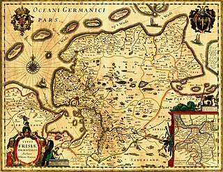
East Frisia or East Friesland is a historic region in the northwest of Lower Saxony, Germany. It is primarily located on the western half of the East Frisian peninsula, to the east of West Frisia and to the west of Landkreis Friesland.
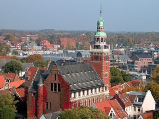
Leer is a town in the district of Leer, in the northwestern part of Lower Saxony, Germany. It is situated on the river Leda, a tributary of the river Ems, near the border with the Netherlands. With 34,958 inhabitants (2021), it is the third-largest city in East Frisia after Emden and Aurich.

Ems-Oriental was a department of the First French Empire in present-day Germany. It was formed in 1810, when the Kingdom of Holland was annexed by France. Its territory is part of the present-day German region of East Frisia in Lower Saxony. Its capital was Aurich. The department was subdivided into the following arrondissements and cantons :
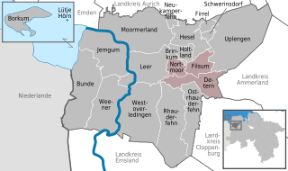
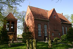
Jümme is a collective municipality (Samtgemeinde) in the district of Leer in the German state of Lower Saxony. It is named after the River Jümme which flows through all three constituent communities. It has an area of 82.34 km2 and a population of 6,421. It is situated in the region of East Frisia. Along with the Samtgemeinde of Hesel, it is one of two in the district. It was formed in the wake of local government reform in 1973. Filsum serves as the administrative centre.
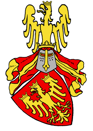
The County of East Frisia was a county in the region of East Frisia in the northwest of the present-day German state of Lower Saxony.

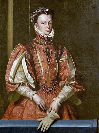
Anna of Oldenburg was a Countess consort of East Frisia as the spouse of Count Enno II of East Frisia. She was the Regent of East Frisia in 1542–1561 as the guardian for her minor sons, Johan II and Edzard II. Her reign lasted until 1561 and was generally supported by the Estates.
The tom Brok family were a powerful East Frisian line of chieftains, originally from the Norderland on the North Sea coast of Germany. From the second half of the 14th century, the tom Broks tried to gain control of East Frisia over the other chieftain families. The line of tom Brok died out in 1435.

Jheringsfehn is a peat village in the region of East Frisia, in Lower Saxony, Germany. Administratively, it is an Ortsteil of the municipality of Moormerland. Warsingsfehn is located just to the east of Warsingsfehn and is approximately 10 kilometers to the northeast of Leer. It has a population of 2,440.
Groothusen is an old Langwurtendorf – a village on an artificially-built ridge – in the municipality of Krummhörn in western East Frisia on Germany's North Sea coast. It lies about 15 kilometres northwest of the seaport of Emden and has a population of 474 (2006). The ridge or warf has a length of about 500 metres and a width of some 130 metres and was built to raise the village above the water level should flooding from the sea occur, for instance, during a storm tide.
Theda Ukena was from 1466 to about 1480 regent of the County of East Frisia.
Uko Fockena was an East Frisian chieftain of Moormerland and Emsigerland.
The Saxon feud was a military conflict in the years 1514–1517 between the East Frisian Count Edzard I, 'West Frisian' rebels, the city of Groningen, and Charles II, Duke of Guelders on the one hand and the Imperial Frisian hereditary governor George, Duke of Saxony – replaced by Charles V of Habsburg in 1515 – and 24 German princes. The war took place predominantly on East Frisian soil and destroyed large parts of the region.

Leer (Ostfriesland) (German pronunciation:[leːɐ̯ʔɔstfʁiːslant]) is a railway station in the town of Leer in Lower Saxony, Germany. The railway station is situated on the Emsland Railway between the railway stations of Emden and Papenburg and it is the railway terminus on the Oldenburg–Leer railway after the railway station of Augustfehn. The train services are operated by Deutsche Bahn, WestfalenBahn and Arriva (a subsidiary of Deutsche Bahn).

Veenhusen is a village in the region of East Frisia, in Lower Saxony, Germany. Administratively, it is an Ortsteil of the municipality of Moormerland. Veenhusen is located just to the south of Warsingsfehn and is approximately 8 kilometers to the northeast of Leer. It has a population of 4,157.

Gandersum is a small village in the region of East Frisia, in Lower Saxony, Germany. Administratively, it is an Ortsteil of the municipality of Moormerland. Located on the north bank of the Ems estuary, Gandersum is to the southeast of Emden and the west of Oldersum. It has a population of 85.
Tergast is a village in the region of East Frisia, in Lower Saxony, Germany. Administratively, it is an Ortsteil of the municipality of Moormerland. Tergast is 1.5 kilometers to the northeast of Oldersum and has a population of 457.

Rorichum is a village in the region of East Frisia, in Lower Saxony, Germany. Administratively, it is an Ortsteil of the municipality of Moormerland. Located on the north bank of the Ems estuary, Rorichum is just to the southeast of Oldersum. It has a population of 444.

Terborg is a small village in the region of East Frisia, in Lower Saxony, Germany. Administratively, it is an Ortsteil of the municipality of Moormerland. Located on the north bank of the river Ems, Terborg is approximately 8 kilometers to the northwest of Leer. It has a population of 105.
Boekzetelerfehn is a village in the region of East Frisia, in Lower Saxony, Germany. Administratively, it is an Ortsteil of the municipality of Moormerland. Boekzetelerfehn is located just to the northeast of Warsingsfehn and is approximately 11 kilometers to the north of Leer. It has a population of 748.

Ulrich von Dornum was a son of the East Frisian chieftain Sibet Attena and his second wife Margarete von Westerwolde.