Amt is a type of administrative division governing a group of municipalities, today only in Germany, but formerly also common in other countries of Northern Europe. Its size and functions differ by country and the term is roughly equivalent to a British or U.S. county.

Thüngersheim is a community located in Germany. The community is situated on the River Main. It is a community in the district of Würzburg. The village is molded by the surrounding vineyards, more than 2 square kilometres (0.8 sq mi).
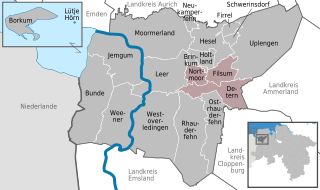
Jümme is a collective municipality (Samtgemeinde) in the district of Leer in the German state of Lower Saxony. It is named after the River Jümme which flows through all three constituent communities. It has an area of 82.34 km² and a population of 6,421. It is situated in the region of East Frisia. Along with the Samtgemeinde of Hesel, it is one of two in the district. It was formed in the wake of local government reform in 1973. Filsum serves as the administrative centre.

The Rheiderland is a region of Germany and the Netherlands between the River Ems and the Bay of Dollart. The German part of the Rheiderland lies in East Frisia, west of the Ems. The Dutch part lies in the Dutch province of Groningen and is mostly part of Oldambt. The Rheiderland is one of the four historic regions on the mainland in the district of Leer; the others being the Overledingerland, the Moormerland and the Lengenerland.
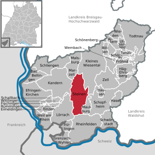
Steinen is a municipality in the district of Lörrach in the southwest of Baden-Württemberg, Germany. It is situated on the river Wiese, 15 km northeast of Basel, and 6 km northeast of Lörrach.
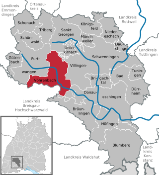
Vöhrenbach is a town in the district of Schwarzwald-Baar, in Baden-Württemberg, Germany. It is situated on the river Breg, 12 km west of Villingen-Schwenningen.

Wangen is a village and municipality in the district of Göppingen in Baden-Württemberg, south-westernGermany. It lies on the edge of the Stuttgart Metropolitan Region.

Sonnefeld is a municipality in the district of Coburg in Bavaria in Germany.

Hottenbach is an Ortsgemeinde – a municipality belonging to a Verbandsgemeinde, a kind of collective municipality – in the Birkenfeld district in Rhineland-Palatinate, Germany. It belongs to the Verbandsgemeinde Herrstein-Rhaunen, whose seat is in Herrstein.
Flörsbachtal is a municipality in the Main-Kinzig district, in Hesse, Germany. It has a population close to 2,400. Flösbachtal contains both the oldest parish and the youngest settlement established in the Spessart hills. Located within the municipal territory is the Hermannskoppe, the highest elevation in the Hessian part of the Spessart and the Wiesbüttmoor, a rare hanging bog.

Travenbrück is a municipality in the district of Stormarn, in Schleswig-Holstein, Germany. The towns of Neverstaven, Nütschau, Schlamersdorf, Sühlen, Tralau and Vinzier are in the municipality.

The Emsigerland, or Emderland was a historic region on the western edge of East Frisia by the Wadden Sea, which covered a wide area around the town of Emden. The Emsigerland borders in the north on the Federgau, in the northeast on the Brokmerland in the east on the Moormerland and in the south on the Rheiderland.

Jheringsfehn is a peat village in the region of East Frisia, in Lower Saxony, Germany. Administratively, it is an Ortsteil of the municipality of Moormerland. Warsingsfehn is located just to the east of Warsingsfehn and is approximately 10 kilometers to the northeast of Leer. It has a population of 2,440.
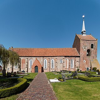
Groothusen is an old Langwurtendorf – a village on an artificially-built ridge – in the municipality of Krummhörn in western East Frisia on Germany's North Sea coast. It lies about 15 kilometres northwest of the seaport of Emden and has a population of 474 (2006). The ridge or warf has a length of about 500 metres and a width of some 130 metres and was built to raise the village above the water level should flooding from the sea occur, for instance, during a storm tide.

Veenhusen is a village in the region of East Frisia, in Lower Saxony, Germany. Administratively, it is an Ortsteil of the municipality of Moormerland. Veenhusen is located just to the south of Warsingsfehn and is approximately 8 kilometers to the northeast of Leer. It has a population of 4,157.
The village of Mittbach is a south-western part of the market town of Isen in the Upper Bavarian district of Erding, Germany. Until the district reform, which came into force on 1 July 1972, the municipality of Mittbach belonged to the district of Wasserburg am Inn. Since then it has belonged to the district of Erding until its dissolution in 1978.
Tergast is a village in the region of East Frisia, in Lower Saxony, Germany. Administratively, it is an Ortsteil of the municipality of Moormerland. Tergast is 1.5 kilometers to the northeast of Oldersum and has a population of 457.

Terborg is a small village in the region of East Frisia, in Lower Saxony, Germany. Administratively, it is an Ortsteil of the municipality of Moormerland. Located on the north bank of the river Ems, Terborg is approximately 8 kilometers to the northwest of Leer. It has a population of 105.

Warsingsfehn is a village in the region of East Frisia, in Lower Saxony, Germany. It is the capital of the municipality of Moormerland. Warsingsfehn is located just to the north of Veenhusen and is approximately 9 kilometers to the north of Leer. With a population of 7,951, it is the most populated village of the municipality.
Boekzetelerfehn is a village in the region of East Frisia, in Lower Saxony, Germany. Administratively, it is an Ortsteil of the municipality of Moormerland. Boekzetelerfehn is located just to the northeast of Warsingsfehn and is approximately 11 kilometers to the north of Leer. It has a population of 748.


