Warsingsfehn

Last updated
Warsingsfehn
ChurchWarsingsfehn.JPG
DEU Warsingsfehn COA.svg
Location of Warsingsfehn
Warsingsfehn
Germany adm location map.svg
Red pog.svg
Warsingsfehn
Lower Saxony location map.svg
Red pog.svg
Warsingsfehn
Coordinates: 53°18′46″N7°29′08″E / 53.31283°N 7.48551°E / 53.31283; 7.48551
Country Germany
State Lower Saxony
District Leer
Municipality Moormerland
Area
   Village of Moormerland 12.6 km2 (4.9 sq mi)
Elevation
1 m (3 ft)
Population
   Metro
7,951
Time zone UTC+01:00 (CET)
  Summer (DST) UTC+02:00 (CEST)
Postal codes
26802
Dialling codes 04954

Warsingsfehn is a village in the region of East Frisia, in Lower Saxony, Germany. It is the capital of the municipality of Moormerland. Warsingsfehn is located just to the north of Veenhusen and is approximately 9 kilometers to the north of Leer. With a population of 7,951, it is the most populated village of the municipality.

Contents

History

The village of Warsingsfehn was created as a moor colony in the 18th century. The village was flooded during the Christmas Flood of 1717 and was then moved to its current, higher location. The birth of the peat colony of Warsingsfehn is considered to be 16 November 1736. On this date, landowner Gerhard Warsing received a leasehold of a raised moor area of 225 hectares. Under his son Hermann Warsing, the lease area was expanded again: in 1769 by 50 hectares, in 1776 by 62 hectares, and in 1779 by ten hectares. [1]

The Warsings gave out the properties on the canal and side canals that branched off at right angles to subleaseholders. They cultivated the moor by first removing the upper layer of white peat and then digging out the black peat underneath to serve as fuel. The peat was then transported by barge to the surrounding cities, especially Emden and Leer, as heating material. After the black peat layer was excavated, the white peat layer was placed back on the moor soil. Since it has little yield, it was mixed with animal dung from the marshes of East Frisia and fertilized in this way. However, the moor settlers were usually only able to make a modest living.

Many people from Warsingsfehn therefore switched to shipping early on. While in 1751 there were five smaller peat ships and four other inland waterway ships on the Warsingsfehn canals, the number had already risen to 31 peat ships by 1816. However, to generate additional sources of income, the captains also sailed in small sea transport between ports on the North Sea coast. In 1816, Warsingsfehn was also home to twelve seagoing ships in addition to the peat ships. By the end of the 19th century, their number had risen to a total of 82, before the advent of steam shipping gave the small sailors competition, against which they could not compete. In addition to the captains and owners, many sailors from Warsingsfehn also went to sea. [1]

Agriculture, which was mostly part-time anyway, could not feed the residents less and less. Between 1816 and 1831 alone, the cultivated area increased from 90 to 205 hectares. At the end of the 19th century, however, there was hardly any moorland left that could be cultivated. There was therefore a wave of emigration to the United States, especially in the last three decades of the 19th century, with more than 100 inhabitants leaving their village.

Due to the social structure (moor colonists, sailors), there was clear support for the SPD in Warsingsfehn since the emergence of the workers' movement, and then also for the Communist Party in the Weimar Republic. However, especially since the May 1924 German federal election, this was always offset by a significant share of votes from right-wing parties. [1] In the July 1932 German federal election, the NSDAP was 50 percent ahead of the SPD (25.2 percent) and the KPD (17 percent) combined. In the second place, however, was the strictly evangelical Christian Social People's Service.

During the National Socialist era, officials from the SPD and KPD were exposed to political persecution. Nine people whose place of birth or residence was Warsingsfehn were killed in the concentration camps Auschwitz, Sobibor, and Kauen. [1]

On the occasion of the Lower Saxony municipal reform, Warsingsfehn was united with the surrounding communities on 1 January 1973 to form the new large municipality of Moormerland. [2] When it came to the question of the location of the municipal administration, Warsingsfehn prevailed over the neighboring town of Neermoor: although Warsingsfehn is one of the youngest towns in the municipality of Moormerland, it had already grown into by far the largest in the early 1970s.

Related Research Articles

<span class="mw-page-title-main">East Frisia</span> Historic region in Lower Saxony, Germany

East Frisia or East Friesland is a historic region in the northwest of Lower Saxony, Germany. It is primarily located on the western half of the East Frisian peninsula, to the east of West Frisia and to the west of Landkreis Friesland.

<span class="mw-page-title-main">Leer, Lower Saxony</span> Town in Lower Saxony, Germany

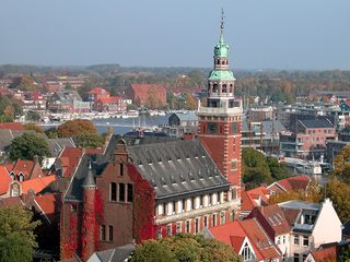
Leer is a town in the district of Leer, in the northwestern part of Lower Saxony, Germany. It is situated on the river Leda, a tributary of the river Ems, near the border with the Netherlands. With 34,958 inhabitants (2021), it is the third-largest city in East Frisia after Emden and Aurich.

<span class="mw-page-title-main">Jümme</span> Samtgemeinde in Lower Saxony, Germany

Jümme is a collective municipality (Samtgemeinde) in the district of Leer in the German state of Lower Saxony. It is named after the River Jümme which flows through all three constituent communities. It has an area of 82.34 km2 and a population of 6,421. It is situated in the region of East Frisia. Along with the Samtgemeinde of Hesel, it is one of two in the district. It was formed in the wake of local government reform in 1973. Filsum serves as the administrative centre.

<span class="mw-page-title-main">Wiesmoor</span> Town in Lower Saxony, Germany

Wiesmoor is a town in the district of Aurich in the northwest of Lower Saxony. It lies on the Nordgeorgsfehnkanal and is the youngest town in the East Frisia area having been bestowed town rights on 16 March 2006, two days later on 18 March 2006, Wiesmoor celebrated the Centenary of the settlements founding. The town owes its growth to the industrialisation of the harvesting of peat from the surrounding moors. Wiesmoor holds an annual flower festival and the town is also known as the ‘Flower City’, the name originates from the large numbers of flowers which are grown in the town’s industrial greenhouse. Formerly the greenhouses were heated by waste heat from the now defunct peat burning power station which was located in the city. Wiesmoor also has the official title of a Luftkurort; tourism now plays an important role in the local economy.

Vossbarg is a row village in East Frisia, Germany. It is a Moorland colony consisting mostly of pasture land and is predominantly an agricultural area.

<span class="mw-page-title-main">Rheiderland</span> Historical region in Germany and the Netherlands

The Rheiderland is a region of Germany and the Netherlands between the River Ems and the Bay of Dollart. The German part of the Rheiderland lies in East Frisia, west of the Ems. The Dutch part lies in the Dutch province of Groningen and is mostly part of Oldambt. The Rheiderland is one of the four historic regions on the mainland in the district of Leer; the others being the Overledingerland, the Moormerland and the Lengenerland.

<span class="mw-page-title-main">Schwerinsdorf</span> Municipality in Lower Saxony, Germany

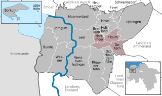
Schwerinsdorf is a municipality in the district of Leer, in Lower Saxony, Germany. The municipality has 705 inhabitants and covers an area of 5.57 square kilometers.

<span class="mw-page-title-main">Hesel (Samtgemeinde)</span> Town in Lower Saxony, Germany

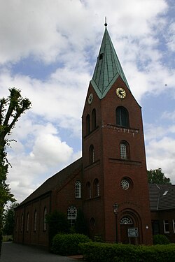
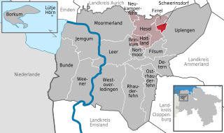
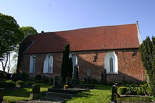
Hesel is a Samtgemeinde in the district of Leer, in Lower Saxony, Germany. Its seat is in the village Hesel.

<span class="mw-page-title-main">Teufelsmoor</span> Moorland region near Bremen, Germany

The Teufelsmoor is a region of bog and moorland north of Bremen, Germany. It forms a large part of the district of Osterholz, and extends into the neighbouring districts of Rotenburg.

<span class="mw-page-title-main">Großes Moor (near Gifhorn)</span> Bog area in Gifhorn district, Lower Saxony, Germany

The Großes Moor near Gifhorn is part of the Northwest German raised bog region, which stretches from the Netherlands to the eastern border of Lower Saxony on the sandy areas (geest) left behind by the ice age. The moor has a total area of about 6,100 hectares, of which around 5,000 hectares are raised bog and some 1,100 hectares are fen. The peat layer is up to almost 6 metres thick in places. Individual parts of the moor have their own names like Stüder Moor, Hestenmoor or Weißes Moor.

<span class="mw-page-title-main">Jheringsfehn</span> Village of Moormerland in Lower Saxony, Germany

Jheringsfehn is a peat village in the region of East Frisia, in Lower Saxony, Germany. Administratively, it is an Ortsteil of the municipality of Moormerland. Warsingsfehn is located just to the east of Warsingsfehn and is approximately 10 kilometers to the northeast of Leer. It has a population of 2,440.

<span class="mw-page-title-main">Bourtange moor</span> Bog area in northern Germany and Netherlands

The Bourtanger Moor was a bog in eastern parts in the Dutch provinces of Drenthe and Groningen and the bordering German districts of Bentheim and Emsland. A remaining stretch on the border between Drenthe and the districts Emsland and Betheim is now a nature reserve, the Internationaler Naturpark Bourtanger Moor-Bargerveen.

<span class="mw-page-title-main">Veenhusen</span> Village of Moormerland in Lower Saxony, Germany

Veenhusen is a village in the region of East Frisia, in Lower Saxony, Germany. Administratively, it is an Ortsteil of the municipality of Moormerland. Veenhusen is located just to the south of Warsingsfehn and is approximately 8 kilometers to the northeast of Leer. It has a population of 4,157.

<span class="mw-page-title-main">Visquard</span> Village of Krummhörn in Lower Saxony, Germany

Visquard is a village in the region of East Frisia, in Lower Saxony, Germany. It is part of the municipality of Krummhörn. The village is located to the north of Pewsum and to the south of Greetsiel.

<span class="mw-page-title-main">Oldersum</span> Village of Moormerland in Lower Saxony, Germany

Oldersum is a village in the region of East Frisia, in Lower Saxony, Germany. Administratively, it is an Ortsteil of the municipality of Moormerland. Located on the north bank of the Ems estuary, Oldersum is to the southeast of Emden and the northwest of Leer. It has a population of 1,533.

<span class="mw-page-title-main">Tergast</span> Village of Moormerland in Lower Saxony, Germany

Tergast is a village in the region of East Frisia, in Lower Saxony, Germany. Administratively, it is an Ortsteil of the municipality of Moormerland. Tergast is 1.5 kilometers to the northeast of Oldersum and has a population of 457.

<span class="mw-page-title-main">Rorichum</span> Village of Moormerland in Lower Saxony, Germany

Rorichum is a village in the region of East Frisia, in Lower Saxony, Germany. Administratively, it is an Ortsteil of the municipality of Moormerland. Located on the north bank of the Ems estuary, Rorichum is just to the southeast of Oldersum. It has a population of 444.

<span class="mw-page-title-main">Terborg, Germany</span> Village of Moormerland in Lower Saxony, Germany

Terborg is a small village in the region of East Frisia, in Lower Saxony, Germany. Administratively, it is an Ortsteil of the municipality of Moormerland. Located on the north bank of the river Ems, Terborg is approximately 8 kilometers to the northwest of Leer. It has a population of 105.

Boekzetelerfehn is a village in the region of East Frisia, in Lower Saxony, Germany. Administratively, it is an Ortsteil of the municipality of Moormerland. Boekzetelerfehn is located just to the northeast of Warsingsfehn and is approximately 11 kilometers to the north of Leer. It has a population of 748.

<span class="mw-page-title-main">Hatshausen</span> Village of Moormerland in Lower Saxony, Germany

Hatshausen is a village in the region of East Frisia, in Lower Saxony, Germany. Administratively, it is an Ortsteil of the municipality of Moormerland. Hatshausen is located to the northeast of Warsingsfehn and Boekzetelerfehn, and is approximately 13 kilometers to the northeast of Leer. It has a population of 602.

References

  1. 1 2 3 4 Badewien, Rita; Böttcher, Constanze. "Warsingsfehn, Gemeinde Moormerland, Landkreis Leer" (PDF). Ostfriesischen Landschaft (in German). Retrieved 22 March 2024.
  2. Statistisches Bundesamt (Hrsg.) (1983). Historisches Gemeindeverzeichnis für die Bundesrepublik Deutschland. Namens-, Grenz- und Schlüsselnummernänderungen bei Gemeinden, Kreisen und Regierungsbezirken vom 27. 5. 1970 bis 31[Historical municipal directory for the Federal Republic of Germany. Name, border and key number changes in municipalities, districts and administrative districts from 27 May to 31 May 1970] (in German). Stuttgart/Mainz: W. Kohlhammer GmbH. p. 262. ISBN   3170032631.