David Fabricius was a German pastor who made two major discoveries in the early days of telescopic astronomy, jointly with his eldest son, Johannes Fabricius (1587–1615).
Fabricius is a surname. Notable people with the surname include:
Johann Goldsmid, better known by his Latinized name Johann(es) Fabricius, eldest son of David Fabricius (1564–1617), was a Frisian/German astronomer and a modern era discoverer of sunspots in 1611, preceded by Thomas Harriot and followed by Galileo Galilei.

Norden is a town in the district of Aurich, in Lower Saxony, Germany. It is situated near the North Sea shore, in East Frisia.
The year 1564 in science and technology included many events, some of which are listed here.

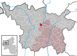
Rhaunen is an Ortsgemeinde – a municipality belonging to a Verbandsgemeinde, a kind of collective municipality – in the Birkenfeld district in Rhineland-Palatinate, Germany. It was the seat of the former Verbandsgemeinde Rhaunen.
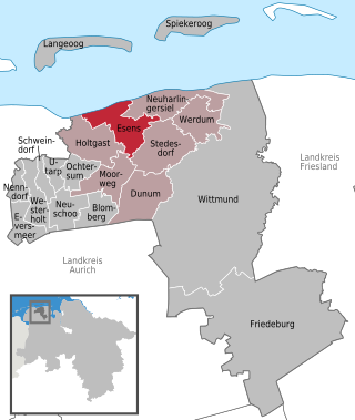
Esens is a municipality in the district of Wittmund, in Lower Saxony, Germany. It is situated near the North Sea coast, approx. 14 km northwest of Wittmund, and 20 km northeast of Aurich.
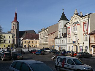
Králíky is a town in Ústí nad Orlicí District in the Pardubice Region of the Czech Republic. It has about 4,100 inhabitants. The historic town centre is well preserved and is protected by law as an urban monument zone.

Armsheim is an Ortsgemeinde – a municipality belonging to a Verbandsgemeinde, a kind of collective municipality – in the Alzey-Worms district in Rhineland-Palatinate, Germany. Armsheim lies in the Rhenish-Hessian Hills, has roughly 2,650 inhabitants and is the third biggest municipality within the Verbandsgemeinde of Wörrstadt, whose seat is in the like-named municipality. The current Armsheim was formed out of two formerly autonomous centres in 1969, named Armsheim and Schimsheim.
Obersülzen is an Ortsgemeinde – a municipality belonging to a Verbandsgemeinde, a kind of collective municipality – in the Bad Dürkheim district in Rhineland-Palatinate, Germany. It lies in the northwest of the Rhine-Neckar urban agglomeration.
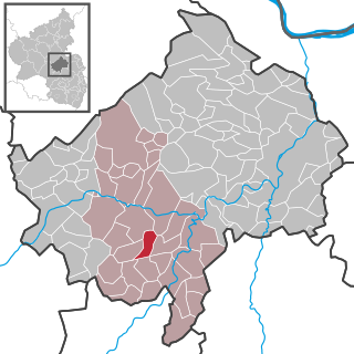
Lauschied is an Ortsgemeinde – a municipality belonging to a Verbandsgemeinde, a kind of collective municipality – in the Bad Kreuznach district in Rhineland-Palatinate, Germany. It belongs to the Verbandsgemeinde of Bad Sobernheim, whose seat is in the like-named town.
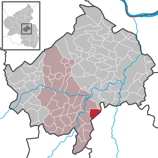
Lettweiler is an Ortsgemeinde – a municipality belonging to a Verbandsgemeinde, a kind of collective municipality – in the Bad Kreuznach district in Rhineland-Palatinate, Germany. It belongs to the Verbandsgemeinde of Meisenheim, whose seat is in the like-named town. Lettweiler is a winegrowing village.

Dennweiler-Frohnbach is an Ortsgemeinde – a municipality belonging to a Verbandsgemeinde, a kind of collective municipality – in the Kusel district in Rhineland-Palatinate, Germany. It belongs to the Verbandsgemeinde of Kusel-Altenglan, whose seat is in Kusel.
Rutsweiler an der Lauter is an Ortsgemeinde – a municipality belonging to a Verbandsgemeinde, a kind of collective municipality – in the Kusel district in Rhineland-Palatinate, Germany. It belongs to the Verbandsgemeinde Lauterecken-Wolfstein. Rutsweiler an der Lauter is one of two places in the Kusel district named Rutsweiler. The other is Rutsweiler am Glan, lying some 13 km to the west-southwest.
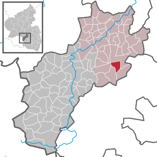
Dill is an Ortsgemeinde – a municipality belonging to a Verbandsgemeinde, a kind of collective municipality – in the Rhein-Hunsrück-Kreis (district) in Rhineland-Palatinate, Germany. It belongs to the Verbandsgemeinde of Kirchberg, whose seat is in the like-named town, and it is home to a castle ruin that bears the same name.
Betteldorf is an Ortsgemeinde – a municipality belonging to a Verbandsgemeinde, a kind of collective municipality – in the Vulkaneifel district in Rhineland-Palatinate, Germany. It belongs to the Verbandsgemeinde of Daun, whose seat is in the like-named town.

Dockweiler is an Ortsgemeinde – a municipality belonging to a Verbandsgemeinde, a kind of collective municipality – in the Vulkaneifel district in Rhineland-Palatinate, Germany. It belongs to the Verbandsgemeinde of Daun, whose seat is in the like-named town.

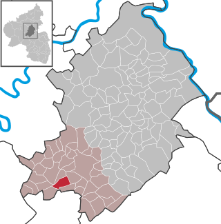
Kolverath is an Ortsgemeinde – a municipality belonging to a Verbandsgemeinde, a kind of collective municipality – in the Vulkaneifel district in Rhineland-Palatinate, Germany. It belongs to the Verbandsgemeinde of Kelberg, whose seat is in the like-named municipality.

Koldenbüttel is a municipality in the district of Nordfriesland, in Schleswig-Holstein, Germany.
Benešov nad Černou is a municipality and village in Český Krumlov District in the South Bohemian Region of the Czech Republic. It has about 1,400 inhabitants. The centre of Benešov nad Černou is well preserved and is protected by law as an urban monument zone.