Aurich (district)

Last updated
Aurich
Juist, Bahnhofstrasse -- 2014 -- 3684-8.jpg
Juist, Bahnhofstraße a municipality in Aurich
Flagge Landkreis Aurich.svg
DEU Landkreis Aurich COA.svg
Aurich (district)
Country Germany
State Lower Saxony
Capital Aurich
Government
  District admin.Olaf Meinen
Area
  Total1,287 km2 (497 sq mi)
Population
 (31 December 2021) [1]
  Total190,425
  Density150/km2 (380/sq mi)
Time zone UTC+01:00 (CET)
  Summer (DST) UTC+02:00 (CEST)
Vehicle registration AUR, NOR
Website www.landkreis-aurich.de

Aurich is a district (Landkreis) in Lower Saxony, Germany. It is bounded by (from the north and clockwise) the North Sea, the districts of Wittmund and Leer, and the city of Emden.

Contents

History

The history of the district is linked with the history of the region of East Frisia.

The district was established in 1977 by merging the former districts of Aurich and Norden.

Geography

The district is located in the westernmost part of East Frisia (Ostfriesland). In the west there is the mouth of the river Ems and the Krummhörn peninsula protruding into the estuary. With a population of approximately 190,000 (as of 31 December 2016) it is the biggest district of East Frisia.

The district includes the three populated islands of Juist, Norderney and Baltrum, which belong to the East Frisian Islands. The small island of Memmert south of Juist is a nature reserve housing rare birds. Part of the district belongs to the Lower Saxony Wadden Sea National Park.

Islands: Norderney 26 km², pop. 6100; Juist 16 km², pop. 1800; Baltrum 6.5 km², pop. 500; Memmert 5.2 km², pop. 0.

Coats of arms

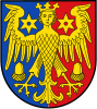
The coat of arms, granted in 1978, displays the so-called virgin eagle (or harpy), which was the heraldic animal of the Cirksena family, a local clan providing East Frisian chieftains during the Middle Ages. The acorns in the arms are symbols of the city of Aurich and the six-pointed spurs are symbols of Norden. The blazon is: "party per pale Azure and Gules, a harpy gardant Argent, above shoulders two six-pointed mullets Argent, below wings two acorns inverted Argent".

The former coat of arms, granted in 1950, shows a golden oak tree, representing the Upstalbeam  [ fy ], a tree outside the city of Aurich under which free Frisians gathered for their yearly council meetings. Its blazon is: "Gules, an oak tree Or, on a hill Or at base".

Cities and municipalities

Clickable map of municipalities in the district Municipalities in AUR.svgNorden
Clickable map of municipalities in the district
CitiesFree municipalities Samtgemeinden
  1. Aurich
  2. Norden
  3. Norderney
  4. Wiesmoor
  1. Baltrum
  2. Dornum
  3. Großefehn
  4. Großheide
  5. Hinte
  6. Ihlow
  7. Juist
  8. Krummhörn
  9. Südbrookmerland

1. Brookmerland

  1. Leezdorf
  2. Marienhafe 1
  3. Osteel
  4. Rechtsupweg
  5. Upgant-Schott
  6. Wirdum

2. Hage

  1. Berumbur
  2. Hage 1
  3. Hagermarsch
  4. Halbemond
  5. Lütetsburg
1seat of the Samtgemeinde

Related Research Articles

<span class="mw-page-title-main">East Frisian Islands</span> Chain of German islands in the North Sea

The East Frisian Islands are a chain of islands in the North Sea, off the coast of East Frisia in Lower Saxony, Germany. The islands extend for some 90 kilometres (56 mi) from west to east between the mouths of the Ems and Jade / Weser rivers and lie about 3.5 to 10 km offshore. Between the islands and the mainland are extensive mudflats, known locally as Watten, which form part of the Wadden Sea. In front of the islands are Germany's territorial waters, which occupy a much larger area than the islands themselves. The islands, the surrounding mudflats and the territorial waters form a close ecological relationship. The island group makes up about 5% of the Lower Saxony Wadden Sea National Park.

<span class="mw-page-title-main">Wittmund (district)</span> District in Lower Saxony, Germany

Wittmund is a Landkreis (district) in the northwestern part of Lower Saxony, Germany. It is situated in East Frisia, on the North Sea coast. Neighboring districts are Friesland, Leer and Aurich.

Friesland is a district (Landkreis) in Lower Saxony, Germany. It is bounded by the districts of Wesermarsch, Ammerland, Leer and Wittmund, and by the North Sea. The city of Wilhelmshaven is enclosed by—but not part of—the district.

Leer is a district (Landkreis) in Lower Saxony, Germany. It is bounded by the city of Emden, the districts of Aurich, Wittmund, Friesland, Ammerland, Cloppenburg and Emsland, and by the Netherlands.

<span class="mw-page-title-main">East Frisia</span> Historic region in Lower Saxony, Germany

East Frisia or East Friesland is a historic region in the northwest of Lower Saxony, Germany. It is primarily located on the western half of the East Frisian peninsula, to the east of West Frisia and to the west of Landkreis Friesland.

<span class="mw-page-title-main">Ammerland</span> District in Lower Saxony, Germany

Ammerland is a district in Lower Saxony, Germany. It is bounded by the city of Oldenburg and the districts of Oldenburg, Cloppenburg, Leer, Friesland and Wesermarsch.

<span class="mw-page-title-main">Aurich</span> Town in Lower Saxony, Germany

Aurich is a town in the East Frisian region of Lower Saxony, Germany. It is the capital of the district of Aurich and is the second largest City in East Frisia, both in population, after Emden, and in area, after Wittmund.

<span class="mw-page-title-main">Frisian Islands</span> Archipelago in the Wadden Sea

The Frisian Islands, also known as the Wadden Islands or the Wadden Sea Islands, form an archipelago at the eastern edge of the North Sea in northwestern Europe, stretching from the northwest of the Netherlands through Germany to the west of Denmark. The islands shield the mudflat region of the Wadden Sea from the North Sea.

<span class="mw-page-title-main">Wittmund</span> Town in Lower Saxony, Germany


Wittmund is a town and capital of the district of Wittmund, in Lower Saxony, Germany.

<span class="mw-page-title-main">Norderney</span> Town in Lower Saxony, Germany

Norderney is one of the seven populated East Frisian Islands off the North Sea coast of Germany.

<span class="mw-page-title-main">Juist</span> Municipality in Lower Saxony, Germany

Juist is an island and municipality in the district of Aurich in Lower Saxony in Germany. The island is one of seven East Frisian Islands at the edge of the Lower Saxon Wadden Sea in the southern North Sea. It is located between Borkum Island (west), Memmert Island (southwest) and Norderney (east). The island is 17 km (11 mi) long and from 500 metres (1,600 ft) to 1 kilometre (0.62 mi) wide, depending on the tide levels. There are two villages on the island: the main village Juist, and Loog. The island is separated from Norderney by the Norderneyer Seegatt.

<span class="mw-page-title-main">Baltrum</span> Municipality in Lower Saxony, Germany

Baltrum is a barrier island off the coast of East Frisia, in Germany, and is a municipality in the district of Aurich, Lower Saxony. It is located in-between the chain of the seven inhabited East Frisian Islands. Baltrum is the smallest island in this chain by area and inhabitants. It has a land area of 6.5 square kilometres, and a population in (2011) of just over 500 resident inhabitants.

<span class="mw-page-title-main">Neßmersiel</span>

Neßmersiel belongs to the municipality Dornum in the rural district Aurich in Lower Saxony, Germany. Neßmersiel is located about 5 kilometres northwest of Dornum. From 1867 to 1977, Neßmersiel belonged to Norden.

<span class="mw-page-title-main">Luftverkehr Friesland-Harle</span> German regional airline

Luftverkehr Friesland-Harle, commonly abbreviated LFH, was a small airline based in Wangerland, Germany, that was established in 1983 and had 30 employees. It operated scheduled and chartered passenger and cargo flights, linking Harle Airfield to the East Frisian Islands. In 2011, LFH was acquired by FLN Frisia Luftverkehr, which continues to use the brand.

<span class="mw-page-title-main">Lower Saxon Wadden Sea National Park</span> National Park in Lower Saxony, Germany

The Lower Saxon Wadden Sea National Park was established in 1986 and embraces the East Frisian Islands, mudflats and salt marshes between the Bay of Dollart on the border with the Netherlands in the west and Cuxhaven as far as the Outer Elbe shipping channel in the east. The national park has an area of about 345,800 hectares (1,335 sq mi). The National Park organisation is located in Wilhelmshaven. In June 2009, the National Park became a UNESCO World Heritage Site along with the Schleswig-Holstein Wadden Sea and the Dutch Wadden Sea, highlighting its unique intertidal ecosystem and high biodiversity.

<span class="mw-page-title-main">Norddeich (Norden)</span> Ortsteil of Norden in Lower Saxony, Germany

Norddeich is a village in the borough of Norden in north Germany with 1,540 inhabitants (2011). It lies in northwestern East Frisia, Lower Saxony on the North Sea coast.

<span class="mw-page-title-main">Cirksena</span> Ruling family of East Frisia

The House of Cirksena was the name of the ruling family of East Frisia. They descended from a line of East Frisian chieftains from Greetsiel.

<span class="mw-page-title-main">East Frisia (peninsula)</span> All Frisian areas in Lower Saxony, Germany

East Frisia is a collective term for all traditionally Frisian areas in Lower Saxony, Germany, which are primarily located on a peninsula between the Dollart and the Jade Bight. Along with West Frisia and North Frisia, it is one of the most commonly used subdivisions of Frisia.

References

  1. "LSN-Online Regionaldatenbank, Tabelle A100001G: Fortschreibung des Bevölkerungsstandes, Stand 31. Dezember 2021" (in German). Landesamt für Statistik Niedersachsen.

Commons-logo.svg Media related to Landkreis Aurich at Wikimedia Commons

53°30′N7°20′E / 53.5°N 7.33°E / 53.5; 7.33