
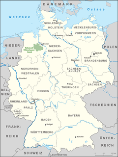
Lower Saxony is a German state (Land) in northwestern Germany. It is the second-largest state by land area, with 47,614 km2 (18,384 sq mi), and fourth-largest in population among the 16 Länder federated as the Federal Republic of Germany. In rural areas, Northern Low Saxon and Saterland Frisian are still spoken, albeit in declining numbers.
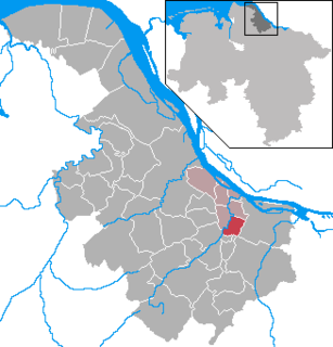
Rotenburg is a district (Landkreis) in Lower Saxony, Germany. It is landlocked by the districts of Stade, Harburg, Heidekreis, Verden, Osterholz and Cuxhaven.
Verden is a Kreis (district) in the centre of Lower Saxony, Germany. Adjoining it are the districts of Osterholz, Rotenburg, Heidekreis, Nienburg, and Diepholz, as well as the city of Bremen.

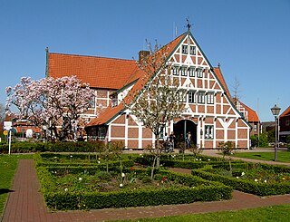
Rotenburg an der Wümme is a town in Lower Saxony, Germany. It is the capital of the district of Rotenburg.
Nienburg is a district (Landkreis) in Lower Saxony, Germany. It is bounded by the districts of Diepholz, Verden, Heidekreis, Hanover and Schaumburg, and by the state of North Rhine-Westphalia.

Bremen-Verden, formally the Duchies of Bremen and Verden, were two territories and immediate fiefs of the Holy Roman Empire, which emerged and gained imperial immediacy in 1180. By their original constitution they were prince-bishoprics of the Archdiocese of Bremen and Bishopric of Verden.
Bouches-du-Weser was a department of the First French Empire in present-day Germany. It was formed in 1811, when the region was annexed by France. Prior to the Napoleonic occupation, its territory had been divided between the Free Hanseatic City of Bremen, the duchy of Oldenburg, and the Hanoverian duchies of Bremen and Verden, the latter of which had intermittently been incorporated into the Kingdom of Westphalia in 1807. Its territory is part of the current German states of Lower Saxony and Bremen. Its capital was Bremen.
Jork is a small town on the left bank of the Elbe, near Hamburg (Germany).
Bützfleth is a village with 5000 inhabitants in the north of the city Stade in Lower Saxony. It borders in the south to Götzdorf, in the northwest to Bützflethermoor and Depenbeck, in the north to Abbenfleth and in the east to the river Elbe.

Lilienthal is a municipality in the administrative district of Osterholz, Lower Saxony, Germany. It borders Bremen.

Grasberg is a municipality in the district of Osterholz, in Lower Saxony, Germany. It is situated approximately 13 km southeast of Osterholz-Scharmbeck, and 20 km northeast of Bremen.

Ritterhude is a municipality in the district of Osterholz, in Lower Saxony, Germany. It is situated on the river Hamme, approx. 6 km southwest of Osterholz-Scharmbeck, and 13 km northwest of Bremen.

Ottersberg is a municipality in the district of Verden, in Lower Saxony, Germany. It is situated approximately 20 km north of Verden, and 28 km east of Bremen.

Bliedersdorf is a municipality in the district of Stade, Lower Saxony, Germany. It is east of Nottensdorf, southwest of Horneburg, and northwest of the simple dolmen megaliths of Grundoldendorf.

Mittelnkirchen is a municipality in the district of Stade, Lower Saxony, Germany.
Neuenkirchen is a municipality in the Altes Land, district of Stade, Lower Saxony, Germany.
The Stade Region emerged in 1823 by an administrative reorganisation of the dominions of the Kingdom of Hanover, a sovereign state, whose then territory is almost completely part of today's German federal state of Lower Saxony. Until 1837 the Kingdom of Hanover was ruled in personal union by the Kings of the United Kingdom of Great Britain and Ireland.

The region between the Elbe and Weser rivers forms the Elbe–Weser triangle, also rendered Elbe-Weser Triangle, in northern Germany. It is also colloquially referred to as the Nasses Dreieck or "wet triangle".
The Wildeshausen Geest is part of the northwest Germany's geest ridge, that begins near Meppen on the river Ems with the Hümmling, is broken by the Weser depression, continues with the Osterholz Geest and reaches the marshes of Kehdingen by the river Elbe with the ridges of the Wingst and Stade Geest. It gives its name to the eponymous nature park.

The Weser Depression or Weser Lowlands is the region north of Porta Westfalica in Germany, where the River Weser no longer flows through a valley, but a broad plain consisting of meadows and river terraces.


