
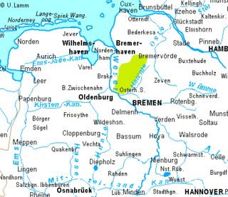
The Teufelsmoor is a region of bog and moorland north of Bremen, Germany. It forms a large part of the district of Osterholz, and extends into the neighbouring districts of Rotenburg (Gnarrenburg municipality).
The Teufelsmoor is a region of bog and moorland north of Bremen, Germany. It forms a large part of the district of Osterholz, and extends into the neighbouring districts of Rotenburg (Gnarrenburg municipality).
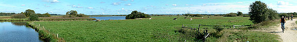
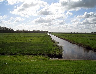
The depression is drained by the rivers Hamme, Wümme and Wörpe. The Teufelsmoor extends over an area of about 500 square kilometres (190 sq mi) and is bordered in the west by the Wesermünde Geest and in the east by the Zeven Geest. The eponymous Teufelsmoor itself is an ombrotrophic raised bog that becomes a fen in the vicinity of the streams that drain it. It is one of the largest contiguous areas of bog in northwest Germany. Its largest extent is about 20 by 20 km. The oldest parts of the terrain in Grasberg have layers of peat eleven metres deep or more. In the centre of the moor is the Worpswede artists' colony, made famous by many landscape artists, which is near the sandy hill of the Weyerberg. Also well-known is the 'moor metropolis' of Gnarrenburg in the heart of the Teufelsmoor.
The name "Teufelsmoor" does not mean "devil's bog" or "devil's moor" as a literal translation would suggest. It is actually derived from doofes Moor (Low Saxon: doof; English: deaf), where doof means "unfertile", "less fertile " or "dead" and moor means "bog" or "moor". Large parts of the Teufelsmoor area consist of raised bog peat which is formed from sphagnum moss. Hence the reason why it is not very fertile.
The outer edges of the Teufelsmoor were first settled in the 17th and 18th centuries. Around 1750 the colonisation of the entire moor began, led by the moor's commissioner, Jürgen Christian Findorff. The settlers were simple farmhands and maids from the surrounding area, who were attracted by the prospect of having their own property and being freed from taxes and military service. Until well into the 20th century the living conditions in these moor colonies were anything other than quaint or attractive. An impression of the very poor circumstances is given by the Low Saxon saying "Den Eersten sien Dood, den Tweeten sien Noot, den Drüdden sien Broot" (translates as something like "The first gets death, the second gets misery, the third gets bread."). Life expectancy in the dark, damp bog dwellings was short and the moor's soils were unsuited to farming.
An extensive network of drainage channels was created, the main drainage ditches being built to act simultaneously as canals for boats. At that time massive inroads were made into the environment and millions of cubic metres of peat were cut. The peat was sold for heating fuel and shipped to Bremen using peat barges, such as those built in the yard in Schlussdorf. The embankments running alongside these canals were used by burlaks to haul the barges and also opened up the long-street villages (Straßendorf) following the practice in the fen (Fehn) regions. From the embankments the narrow and very long strips of land ( Hufen ) that ran out into the moor were farmed. Even today these patterns of settlement (of the linear village or Reihendorf ) can be seen in many parts of the area around the villages of Grasberg and Worpswede.
By harvesting the layers of peat and draining the land the climatic conditions of the entire area were changed considerably. By the end of the 19th century the keeping of dairy cattle had spread to the area. In Bremen the use of peat for heating was banned because on many winters days the air pollution it caused had become unbearable. Coal, with its greater energy density, superseded peat. Right into the 1980s and 1990s, however, there was continued destruction of the moor. Major 'melioration' measures such as draining, deep ploughing (Tiefumbruch) and river regulation were supposed to increase the productivity of agriculture and even enabled arable farming. Intensive farming methods were used to grow maize as an animal feedstuff. These measures had been supported since the middle of the 20th century by various national and European subsidy programmes. This went so far that ditches dried out in summer, heath fires broke out and, during sustained periods of drought, the land was artificially watered.
In the 1990s a major rethink began. By leaving the land to regenerate and by reflooding it, attempts have been made to preserve the original landscape, although the moor in its original state no longer exists. Even those bogs that are still intact - like the Günnemoor - continue to be denuded by industrial peat cutting. Remnants (of peat mounds not peat cuttings) are still visible in the landscape, but their renaturalisation is difficult due to their elevation. The dry conditions encourage the mineralisation of the peat layers and enable woods to develop. In the meantime many small temporary structures have appeared on these areas.
Meanwhile, the Teufelsmoor has become part of the commuter belt for the city of Bremen, and its settlements are growing due to the shortage of building land and the influx of new inhabitants. The history of the Teufelsmoor is thus a good example of the cultural activities of mankind and his will to survive but also of the influences and consequences of this activity. The history of the land and its inhabitants was filmed in the 1982 TV series Teufelsmoor produced by Radio Bremen. This portrays the life of several generations of the Kehdings, a fictional farming family, from the initial time of land reclamation to the end of the 20th century. The Teufelsmoor is also well-known from numerous TV programmes such as the recent murder mystery starring Maria Furtwängler, part of the long-running Tatort series.
| International | |
|---|---|
| National | |

The North York Moors is an upland area in north-eastern Yorkshire, England. It contains one of the largest expanses of heather moorland in the United Kingdom. The area was designated as a National Park in 1952, through the National Parks and Access to the Countryside Act 1949. Covering an area of 554 sq mi (1,430 km2), the National Park has a population of 23,380. It is administered by the North York Moors National Park Authority, which is based in Helmsley.

The Fens or Fenlands in eastern England are a naturally marshy region supporting a rich ecology and numerous species. Most of the fens were drained centuries ago, resulting in a flat, dry, low-lying agricultural region supported by a system of drainage channels and man-made rivers and automated pumping stations. There have been unintended consequences to this reclamation, as the land level has continued to sink and the dykes have been built higher to protect it from flooding.

The Hamme is a 48 km (30 mi) long river in Germany, Lower Saxony, north-east of Bremen. Its source is north of Osterholz-Scharmbeck. It flows through the moors north-east of Bremen called Teufelsmoor, and meets the river Wümme in Ritterhude. From this junction, the river is called Lesum. The Lesum flows into the river Weser in Bremen-Vegesack.
Jümme is a collective municipality (Samtgemeinde) in the district of Leer in the German state of Lower Saxony. It is named after the River Jümme which flows through all three constituent communities. It has an area of 82.34 km2 and a population of 6,421. It is situated in the region of East Frisia. Along with the Samtgemeinde of Hesel, it is one of two in the district. It was formed in the wake of local government reform in 1973. Filsum serves as the administrative centre.
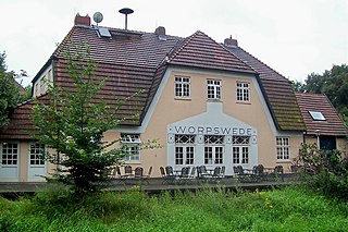
Worpswede is a municipality in the district of Osterholz, in Lower Saxony, Germany. It is situated in the Teufelsmoor, northeast of Bremen. The small town itself is located near the Weyerberg hill. It has been the home to an artistic community since the end of the 19th century.

The North German Plain or Northern Lowland is one of the major geographical regions of Germany. It is the German part of the North European Plain. The region is bounded by the coasts of the North Sea and the Baltic Sea to the north, Germany's Central Uplands to the south, by the Netherlands to the west and Poland to the east.

Raised bogs, also called ombrotrophic bogs, are acidic, wet habitats that are poor in mineral salts and are home to flora and fauna that can cope with such extreme conditions. Raised bogs, unlike fens, are exclusively fed by precipitation (ombrotrophy) and from mineral salts introduced from the air. They thus represent a special type of bog, hydrologically, ecologically and in terms of their development history, in which the growth of peat mosses over centuries or millennia plays a decisive role. They also differ in character from blanket bogs which are much thinner and occur in wetter, cloudier climatic zones.

The region between the Elbe and Weser rivers forms the Elbe–Weser triangle, also rendered Elbe-Weser Triangle, in northern Germany. It is also colloquially referred to as the Nasses Dreieck or "wet triangle".

The Großes Moor near Gifhorn is part of the Northwest German raised bog region, which stretches from the Netherlands to the eastern border of Lower Saxony on the sandy areas (geest) left behind by the ice age. The moor has a total area of about 6,100 hectares, of which around 5,000 hectares are raised bog and some 1,100 hectares are fen. The peat layer is up to almost 6 metres (20 ft) thick in places. Individual parts of the moor have their own names like Stüder Moor, Hestenmoor or Weißes Moor.

Zion's Church is a Lutheran parish church in Worpswede, Lower Saxony, Germany. The church is used and owned by the Lutheran Congregation of Worpswede within the Evangelical Lutheran State Church of Hanover. It was completed in 1759 and forms a landmark located on top of the Weyerberg hill.

The Hanoverian Moor Geest is a gently rolling landscape between Hanover and Nienburg in the German state of Lower Saxony covering an area of around 800 square kilometres (310 sq mi). It belongs to the raised bog regions of northwest Germany, which cover the geest terrain formed during the ice age and which stretch from the Netherlands to the eastern border of Lower Saxony. The geest tract on the Hanoverian Moor Geest consists of a ground moraine plateau with a height of 50–85 metres (164–279 ft) above sea level that is dominated by bog. Its natural boundaries are the Aller glacial valley to the north and the Burgdorf-Peine Geest to the east.
The Wildeshausen Geest is part of the northwest Germany's geest ridge, that begins near Meppen on the river Ems with the Hümmling, is broken by the Weser depression, continues with the Osterholz Geest and reaches the marshes of Kehdingen by the river Elbe with the ridges of the Wingst and Stade Geest. It gives its name to the eponymous nature park.

The Weyerberg is a sandy geest island, 54.4 metres (178 ft) high, in the Teufelsmoor in Northern Germany. It is located near its main settlement of Worpswede in the district of Osterholz in Lower Saxony. Its name means something like 'wooded hill'. It probably emerged at the end of the ice age, when meltwaters deposited sand around its clay core.
The Osterholz Geest is an undulating, sandy area of ground moraine between the city of Bremen and the towns of Bremerhaven and Bremervörde.

The Oste-Hamme Canal or Hamme-Oste Canal is a canal in north Germany, that links the rivers Oste and Hamme. It runs from the Oste near Spreckens four kilometres above Bremervörde through the former Teufelsmoor and Gnarrenburg, until it reaches the Hamme near Viehspecken. The part of the canal near its mouth into the Hamme is also known as Kollbeck.
Land Hadeln is a historic landscape and former administrative district in Northern Germany with its seat in Otterndorf on the Lower Elbe, the lower reaches of the River Elbe, in the Elbe-Weser Triangle between the estuaries of the Elbe and Weser.
The Wesermünde Geest is the collective name for several geest ridges in the west of Cuxhaven district and Bremen's North Borough in northern Germany. The ridges are separated from one another by wetlands. These terminal moraines were formed during the Saale glaciation, are up to between 10 and 70 m above sea level (NN), and are covered by scattered woods and farmland. The wetland areas, between 0 and 5 m above sea level, are predominantly used for grazing.
The Semkenfahrt is part of a canal system in Germany. It was used in former times by barges to bring peat from the Teufelsmoor area to the town of Bremen. In the area of Teufelsmoor the peat was dug and dried, and in Bremen it was used for heating purposes.

The Großes Moor is the proper name for a contiguous region of raised bog between the towns of Damme, Lohne and Vechta and the village of Goldenstedt in the county of Vechta on the one hand, and the villages of Diepholz and Barnstorf in Diepholz and Bramsche in Osnabrück in Lower Saxony on the other, all within Germany.
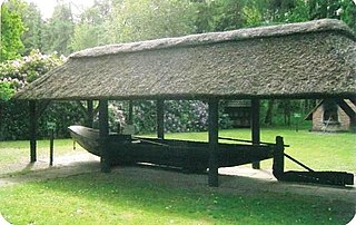
The Turf Shipyard in Schlussdorf, Lower Saxony, Germany, is a former boat builder's yard now used as an open-air museum. The yard, operating from 1850 to 1954, was specialised on barges to transport turf, that is dried peat used as fuel. In 1975 the Heimatverein Schlußdorf started to rescue the dilapidated shipyard buildings and reopened the site as a museum in 1977. The Turf Shipyard is about 3 kilometres (1.9 mi) north of Worpswede's outskirts.