
The Weser is a river in Northwestern Germany. Formed at Hannoversch Münden by the confluence of the rivers Fulda and Werra, it flows through Lower Saxony, then reaching the Hanseatic city of Bremen, before emptying 50 km (31 mi) further north at Bremerhaven into the North Sea. On the opposite (west) bank is the town of Nordenham at the foot of the Butjadingen Peninsula; thus, the mouth of the river is in Lower Saxony. The Weser has an overall length of 452 km (281 mi). Together with its Werra tributary, which originates in Thuringia, its length is 744 km (462 mi).
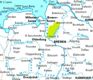
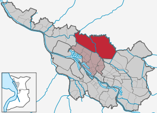
Osterholz is a district (Landkreis) in Lower Saxony, Germany. It is bounded by the districts of Wesermarsch, Cuxhaven, Rotenburg and Verden, and by the city of Bremen.
Rotenburg is a district (Landkreis) in Lower Saxony, Germany. It is landlocked by the districts of Stade, Harburg, Heidekreis, Verden, Osterholz and Cuxhaven.
Verden is a Kreis (district) in the centre of Lower Saxony, Germany. Adjoining it are the districts of Osterholz, Rotenburg, Heidekreis, Nienburg and Diepholz, as well as the city of Bremen.

The Grand Canal is the southernmost of a pair of canals that connect Dublin, in the east of Ireland, with the River Shannon in the west, via Tullamore and a number of other villages and towns, the two canals nearly encircling Dublin's inner city. Its sister canal on the Northside of Dublin is the Royal Canal. The last working cargo barge passed through the Grand Canal in 1960.

The Hamme is a 48 km (30 mi) long river in Germany, Lower Saxony, north-east of Bremen. Its source is north of Osterholz-Scharmbeck. It flows through the moors north-east of Bremen called Teufelsmoor, and meets the river Wümme in Ritterhude. From this junction, the river is called Lesum. The Lesum flows into the river Weser in Bremen-Vegesack.

Ritterhude is a municipality in the district of Osterholz, in Lower Saxony, Germany. It is situated on the Hamme River, approx. 6 km southwest of Osterholz-Scharmbeck, and 13 km northwest of Bremen.

The Stainforth and Keadby Canal is a navigable canal in South Yorkshire and Lincolnshire, England. It connects the River Don Navigation at Bramwith to the River Trent at Keadby, by way of Stainforth, Thorne and Ealand, near Crowle. It opened in 1802, passed into the control of the River Don Navigation in 1849, and within a year was controlled by the first of several railway companies. It became part of the Sheffield and South Yorkshire Navigation, an attempt to remove several canals from railway control, in 1895. There were plans to upgrade it to take larger barges and to improve the port facilities at Keadby, but the completion of the New Junction Canal in 1905 made this unnecessary, as Goole could easily be reached and was already a thriving port.

The Rhine–Herne Canal is a 45.6-kilometre-long (28.3 mi) transportation canal in the Ruhr area of North Rhine-Westphalia, Germany, with five canal locks. The canal was built over a period of eight years and connects the harbour in Duisburg on the Rhine with the Dortmund-Ems Canal near Henrichenburg, following the valley of the Emscher. It was widened in the 1980s. The Rhein-Herne canal ship was designed specifically for this canal; normally of about 1300–1350 ton capacity, it has a maximum draft of 2.50 metres (8.2 ft), a length of approximately 80 metres (260 ft), and maximum beam of 9.50 metres (31.2 ft).
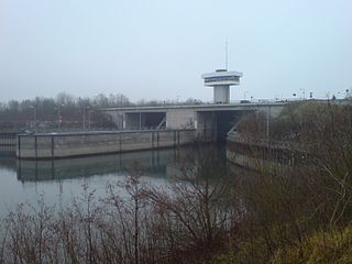
The Iffezheim Lock is a river lock on the Rhine near Iffezheim in Baden-Württemberg, Germany. The two passages of the lock serve to allow ships and barges to bypass the hydropower station on the French side of the river.

The Teufelsmoor is a region of bog and moorland north of Bremen, Germany. It forms a large part of the district of Osterholz, and extends into the neighbouring districts of Rotenburg.

The region between the Elbe and Weser rivers forms the Elbe–Weser triangle, also rendered Elbe-Weser Triangle, in northern Germany. It is also colloquially referred to as the Nasses Dreieck or "wet triangle".
The Osterholz Geest is an undulating, sandy area of ground moraine between the city of Bremen and the towns of Bremerhaven and Bremervörde.

The Oste-Hamme Canal or Hamme-Oste Canal is a canal in north Germany, that links the rivers Oste and Hamme. It runs from the Oste near Spreckens four kilometres above Bremervörde through the former Teufelsmoor and Gnarrenburg, until it reaches the Hamme near Viehspecken. The part of the canal near its mouth into the Hamme is also known as Kollbeck.
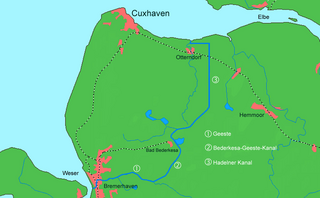
The Elbe–Weser waterway or Elbe–Weser shipping channel is a short-cut between the rivers Elbe and Weser in North Germany which is part-canal and part-river. It has a length of 54.7 kilometres (34.0 mi) and is designed for smaller coastal vessels. It includes some 60 kilometres (37 mi) of canal dykes and 45 kilometres (28 mi) of canal paths. The channel starts in Otterndorf with the Hadeln Canal, then becomes the Bederkesa-Geeste Canal from the town of Bad Bederkesa to the River Geeste, the final leg of the shipping channel, which flows into the Weser at Bremerhaven. It is owned by the state of Lower Saxony, maintained by the NLWKN from its Stade office. Today they just look after maintenance of the drainage system, because the economic element of the canal – commercial shipping which was particularly thriving in the late 1960s – declined increasingly from 1973 onwards and today hardly exists at all. Nevertheless the waterway is still used by smaller yachts as a short cut between Elbe and Weser.

Thorne and Hatfield Moors Peat Canals were a series of canals in South Yorkshire and Lincolnshire, England, which were used to carry cut peat from Thorne and Hatfield Moors to points where it could be processed or exported. There were two phases to the canals, the first of which lasted from the 1630s until the 1830s, when coal imported on the Stainforth and Keadby Canal reduced the demand for peat as a fuel. The second started in the 1890s, when peat found a new use as bedding for working horses, and lasted until 1922, when Moorends Mill which processed the peat was destroyed by fire.
The Zeven Geest, which is part of the Stade Geest, is an area of sandy terrain in the northeast of the German state of Lower Saxony. It is named after the town of Zeven.
The Wesermünde Geest is the collective name for several geest ridges in the west of Cuxhaven district and Bremen's North Borough in northern Germany. The ridges are separated from one another by wetlands. These terminal moraines were formed during the Saale glaciation, are up to between 10 to 70 m above sea level (NN), and are covered by scattered woods and farmland. The wetland areas, between 0 to 5 m above sea level, are predominantly used for grazing.
Fischerhude is a village located next to the Wümme river in northern Germany between Bremen and Hamburg. Fischerhude is part of the municipality of Ottersberg, in the district of Verden.
Blockland is a landscape and nowadays a borough of Bremen, Germany. It is part of the Western municipal district and covers an area of 30.3 km².
