Lower Saxony is a German state in northwestern Germany. It is the second-largest state by land area, with 47,614 km2 (18,384 sq mi), and fourth-largest in population among the 16 Länder federated as the Federal Republic of Germany. In rural areas, Northern Low Saxon and Saterland Frisian are still spoken, albeit in declining numbers.
Osterholz is a district (Landkreis) in Lower Saxony, Germany. It is bounded by the districts of Wesermarsch, Cuxhaven, Rotenburg and Verden, and by the city of Bremen.
Gifhorn is a district in Lower Saxony, Germany.
Osnabrück is a district (Landkreis) in the southwest of Lower Saxony, Germany. With 2,122 km2 it is the second largest district of Lower Saxony.
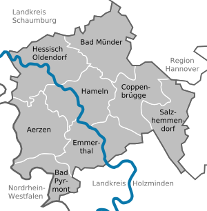
Schaumburg is a district (Landkreis) of Lower Saxony, Germany. It is bounded by the districts of Nienburg, Hanover and Hameln-Pyrmont, and the state of North Rhine-Westphalia.
Hanover Region is a district in Lower Saxony, Germany. It is bounded by the districts of Heidekreis, Celle, Gifhorn, Peine, Hildesheim, Hameln-Pyrmont, Schaumburg and Nienburg.
Peine is a district in Lower Saxony, Germany. It is bounded by the districts of Hildesheim, Hanover and Gifhorn, and the cities of Brunswick and Salzgitter.
Hildesheim is a district (Landkreis) in Lower Saxony, Germany. It is bounded by the districts of Hanover, Peine, Wolfenbüttel, Goslar, Northeim, Holzminden and Hameln-Pyrmont.
Holzminden is a district in Lower Saxony, Germany, with the town of Holzminden as its administrative capital. It is bounded by the districts of Hamelin-Pyrmont, Hildesheim and Northeim, and by the state of North Rhine-Westphalia.

Göttingen is a district in Lower Saxony, Germany. It is bounded by the districts of Northeim and Goslar, and by the states of Thuringia and Hesse. The capital is the university city of Göttingen.
Goslar is a district in Lower Saxony, Germany. It is bounded by the districts of Göttingen, Northeim, Hildesheim and Wolfenbüttel, the city of Salzgitter, and by the states of Saxony-Anhalt and Thuringia (Nordhausen).
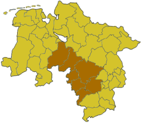
Hanover was a Regierungsbezirk of the German state of Lower Saxony from 1946 until 2004. It was located in the centre and the south of the state, centered on the Lower Saxon capital of Hanover.

The County of Waldeck was a state of the Holy Roman Empire and its successors from the late 12th century until 1929. In 1349 the county gained Imperial immediacy and in 1712 was raised to the rank of principality. After the dissolution of the Holy Roman Empire in 1806 it was a constituent state of its successors: the Confederation of the Rhine, the German Confederation, the North German Confederation, and the German Empire. After the abolition of the monarchy in 1918, the renamed Free State of Waldeck-Pyrmont became a component of the Weimar Republic until divided between Hannover and other Prussian provinces in 1929. It comprised territories in present-day Hesse and Lower Saxony (Germany).
Waldeck-Frankenberg is a Kreis (district) in the north of Hesse, Germany. Neighbouring districts are Höxter, Kassel, Schwalm-Eder, Marburg-Biedenkopf, Siegen-Wittgenstein, Hochsauerland.
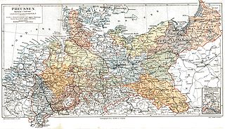
The Provinces of Prussia were the main administrative divisions of Prussia from 1815 to 1946. Prussia's province system was introduced in the Stein-Hardenberg Reforms in 1815, and were mostly organized from duchies and historical regions. Provinces were divided into several Regierungsbezirke, sub-divided into Kreise (districts), and then into Gemeinden (townships) at the lowest level. Provinces constituted the highest level of administration in the Kingdom of Prussia and Free State of Prussia until 1933, when Nazi Germany established de facto direct rule over provincial politics, and were formally abolished in 1946 following World War II. The Prussian provinces became the basis for many federal states of Germany, and the states of Brandenburg, Lower Saxony, and Schleswig-Holstein are direct successors of provinces.

Bad Arolsen is a small town in northern Hesse, Germany, in Waldeck-Frankenberg district. From 1655 until 1918 it served as the residence town of the Princes of Waldeck-Pyrmont and then until 1929 as the capital of the Waldeck Free State. The International Tracing Service has its headquarters in Bad Arolsen.
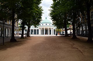
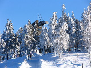
Bad Pyrmont is a town in the district of Hamelin-Pyrmont, in Lower Saxony, Germany, with a population close to 19,000. It is located on the river Emmer, about 10 km (6.2 mi) west of the Weser. Bad Pyrmont is a popular spa resort that gained its reputation as a fashionable place for princely vacations in the 17th and 18th centuries. The town is also the center of the Religious Society of Friends (Quakers) in Germany.

The Province of Hanover was a province of the Kingdom of Prussia and the Free State of Prussia from 1866 to 1946.

The Free State of Waldeck-Pyrmont, later the Free State of Waldeck, was a constituent state of the Weimar Republic. It was created following the German Revolution which forced Prince Friedrich of Waldeck and Pyrmont along with the other German monarchs to abdicate.
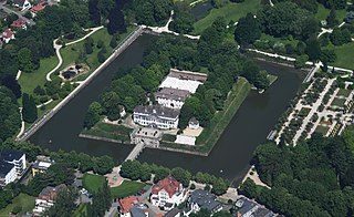
Schloss Pyrmont, sometimes called Pyrmont Castle, was a schloss and the summer residence of the counts of Spiegelberg and counts of Waldeck-Pyrmont in the present-day German town of Bad Pyrmont. The current building dates to the 18th century and houses a museum. The schloss is part of Pyrmont Fortress which dates to the 16th century.