Westoverledingen

Last updated
Westoverledingen
Wappen Gemeinde Westoverledingen.png
Location of Westoverledingen within Leer district
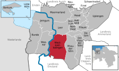
Westoverledingen in LER.svgBundeLeerLeer (Borkum)
Germany adm location map.svg
Red pog.svg
Westoverledingen
Lower Saxony location map.svg
Red pog.svg
Westoverledingen
Coordinates: 53°9′N7°28′E / 53.150°N 7.467°E / 53.150; 7.467
Country Germany
State Lower Saxony
District Leer
Subdivisions12 Subdivisions
Government
   Mayor (202126) Theo Douwes [1]
Area
  Total111.9 km2 (43.2 sq mi)
Elevation
4 m (13 ft)
Population
 (2021-12-31) [2]
  Total21,539
  Density190/km2 (500/sq mi)
Time zone UTC+01:00 (CET)
  Summer (DST) UTC+02:00 (CEST)
Postal codes
26810
Dialling codes 0 49 55
Vehicle registration LER
Website www.westoverledingen.de

Westoverledingen is a municipality in the Leer district in Lower Saxony, Germany.

It contains about a dozen villages. The biggest of them are Flachsmeer, Völlen and Ihrhove, where the town hall is located. Völlen lies at the southern edge of the municipality, close to the Meyer-Werft shipyard in Papenburg. Many villagers are employed there.

Most villages have interesting old churches, including five that date from the Middle Ages.

The Bundesstraße 70 the connects the municipality to Papenburg and Leer. Westoverledingen does not have a train station. The Emsland Railway passes the municipality between stations Leer and Papenburg. The Ihrhove–Nieuweschans railway splits off from it towards Weener station. The Ihrhove railway station is to be reopened in 2024 or 2025.

A touristic bicycle trail, following the Ems, goes through Westoverledingen.

Westoverledingen's economy is dominated by agriculture. Many of its inhabitants, however, have a job in nearby towns like Leer or Papenburg.

Villages

Westoverledingen is divided into 12 Ortsteile for administrative purposes. The larger ones have their own elected local councils (Ortsrat) while the smaller ones have a local representative (Ortsvorsteher) appointed by the municipal council. [3]

VillagePopulation [4]
31 December 2020
Local government
Breinermoor325Ortsvorsteher
Driever108Ortsvorsteher
Esklum187Ortsvorsteher
Flachsmeer4737Ortsrat
Folmhusen584Ortsrat
Grotegaste116Ortsvorsteher
Großwolde1670Ortsrat
Ihren1968Ortsrat
Ihrhove3626Ortsrat
Mitling-Mark168Ortsvorsteher
Steenfelde2254Ortsrat
Völlen5771Ortsrat

Related Research Articles

Landkreis Emsland is a district in Lower Saxony, Germany named after the river Ems. It is bounded by the districts of Leer, Cloppenburg and Osnabrück, the state of North Rhine-Westphalia, the district of Bentheim in Lower Saxony, and the Netherlands.

<span class="mw-page-title-main">Leer, Lower Saxony</span> Town in Lower Saxony, Germany

Leer is a town in the district of Leer, in the northwestern part of Lower Saxony, Germany. It is situated on the river Leda, a tributary of the river Ems, near the border with the Netherlands. With 34,958 inhabitants (2021), it is the third-largest city in East Frisia after Emden and Aurich.

<span class="mw-page-title-main">Weener</span> Town in Lower Saxony, Germany

Weener is a town in the district of Leer, in Lower Saxony, Germany. It is situated near the border with the Netherlands, on the river Ems. The towns population is at 15,654, making it the largest town of the region Rheiderland. It has a railway and autobahn connection to Groningen, Netherlands, Emden and Bremen.

<span class="mw-page-title-main">Uplengen</span> Municipality in Lower Saxony, Germany

Uplengen is a municipality in the Leer district, in Lower Saxony, Germany.

<span class="mw-page-title-main">Ostrhauderfehn</span> Municipality in Lower Saxony, Germany

Ostrhauderfehn is a municipality in the Leer district of Lower Saxony, Germany.

<span class="mw-page-title-main">Papenburg</span> Town in Lower Saxony, Germany

Papenburg is a city in the district of Emsland, Lower Saxony, Germany, situated at the river Ems. It is known for its large shipyard, the Meyer-Werft, which specializes in building cruise liners.

<span class="mw-page-title-main">Bad Zwischenahn</span> Municipality in Lower Saxony, Germany

Bad Zwischenahn is a town and a municipality in the low-lying Ammerland district, in Lower Saxony, Germany. It is on Zwischenahner Meer, approximately 15 km northwest of Oldenburg and about 70 km south of the North Sea coast.

<span class="mw-page-title-main">Krummhörn</span> Municipality in Lower Saxony, Germany

Krummhörn is a municipality in the district of Aurich, in Lower Saxony, Germany. It is situated near the Ems estuary, approximately 15 km southwest of Norden, and 10 km northwest of Emden.

<span class="mw-page-title-main">Wietmarschen</span> Municipality in Lower Saxony, Germany

Wietmarschen is a unitary municipality (Einheitsgemeinde) in the district of Grafschaft Bentheim in Lower Saxony, Germany. It is split into the villages of Wietmarschen, Füchtenfeld, Schwartenpohl, Lohnerbruch, Nordlohne and Lohne with Lohne being the biggest and having the town hall while Wietmarschen, which is the second biggest, having the name.

<span class="mw-page-title-main">Eschede</span> Municipality in Lower Saxony, Germany

Eschede is a municipality in the district of Celle, in Lower Saxony, Germany. Situated approximately 15 km northeast of Celle, Eschede lies at the border of the Südheide Nature Park, a protected area of large forests and heaths. Today around 20 small villages are part of the "Gemeinde Eschede".

<span class="mw-page-title-main">Essen (Oldenburg)</span> Municipality in Lower Saxony, Germany

Essen (Oldenburg) is a municipality in the district of Cloppenburg, in Lower Saxony, Germany. It is on the river Hase, about 5 kilometres (3.1 mi) north of Quakenbrück and 15 kilometres (9.3 mi) southwest of Cloppenburg.

<span class="mw-page-title-main">Beverstedt</span> Municipality in Lower Saxony, Germany

Beverstedt is a municipality in the district of Cuxhaven, in Lower Saxony, Germany. It is situated approximately 20 km southeast of Bremerhaven, and 40 km north of Bremen.

<span class="mw-page-title-main">Rhede, Lower Saxony</span> Municipality in Lower Saxony, Germany

Rhede is a municipality in the Emsland district, Lower Saxony, Germany. It is situated on the river Ems, near the border with the Netherlands, approx. 10 km west of Papenburg, and 20 km southeast of Winschoten.

<span class="mw-page-title-main">Gleichen, Lower Saxony</span> Municipality in Lower Saxony, Germany

Gleichen is a municipality in the district of Göttingen, in Lower Saxony, Germany. Named after the two castles, Neuen-Gleichen and Alten-Gleichen on the twin peaks in the Gemeinde, it is situated about 10 km southeast of Göttingen, from which the peaks are visible. Its seat is Reinhausen.

<span class="mw-page-title-main">Neu Wulmstorf</span> Municipality in Lower Saxony, Germany

is a municipality ('Einheitsgemeinde') in the district of Harburg, in Lower Saxony, Germany. It changed its name on December 11, 1964 from ″Wulmstorf″ to ″Neu Wulmstorf″. It is part of the Hamburg Metropolitan Region.

<span class="mw-page-title-main">Seevetal</span> Municipality in Lower Saxony, Germany

Seevetal is a municipality in the district of Harburg, in Lower Saxony, Germany. It is situated approximately 20 km south of Hamburg, and 15 km west of Winsen (Luhe). Its seat is in the village Hittfeld. It is named after the river Seeve.

<span class="mw-page-title-main">Bunde, Germany</span> Municipality in Lower Saxony, Germany

Bunde is a municipal district in East Frisia, in Lower Saxony, Germany, about 20 km (12 mi) south of Emden, Germany, and 50 km (30 mi) east of Groningen, Netherlands. It lies on the southern tip of the Dollart, a bay of the North Sea between Germany and the Netherlands, and has a land border with the Netherlands.

<span class="mw-page-title-main">Uetze</span> Municipality in Lower Saxony, Germany

Uetze [ˈʏt͡sə] is a municipality in the district of Hanover, in Lower Saxony, Germany. It is situated on the river Fuhse, approximately 35 km (22 mi) east of Hanover.

<span class="mw-page-title-main">Leer (Ostfriesland) railway station</span>

Leer (Ostfriesland) (German pronunciation:[leːɐ̯ʔɔstfʁiːslant]) is a railway station in the town of Leer in Lower Saxony, Germany. The railway station is situated on the Emsland Railway between the railway stations of Emden and Papenburg and it is the railway terminus on the Oldenburg–Leer railway after the railway station of Augustfehn. The train services are operated by Deutsche Bahn, WestfalenBahn and Arriva (a subsidiary of Deutsche Bahn).

<span class="mw-page-title-main">Schladen-Werla</span> Municipality in Lower Saxony, Germany

Schladen-Werla is a municipality in the district of Wolfenbüttel, in Lower Saxony, Germany. It was formed on 1 November 2013, when the municipalities of the former Samtgemeinde Schladen: Gielde, the town of Hornburg, Schladen proper, and Werlaburgdorf were merged.

References

  1. "Direktwahlen in Niedersachsen vom 12. September 2021" (PDF). Landesamt für Statistik Niedersachsen. 13 October 2021.
  2. "LSN-Online Regionaldatenbank, Tabelle A100001G: Fortschreibung des Bevölkerungsstandes, Stand 31. Dezember 2021" (in German). Landesamt für Statistik Niedersachsen.
  3. Gemeinde Westoverledingen: Ortsbürgermeister und Ortsvorsteher, last visited on 16 March 2022.
  4. Gemeinde Westoverledingen: Bevölkerung, last visited on 16 March 2022.